Return to the watershed explorer ·
Four drainage studies.
Eight source sheets.
USGS watershed boundaries, recorded channels and derived terrain answer different questions. These are historical source records and model outputs, not current water, surveyed boundaries or field navigation.
Bryce Creek-Paria River drainage study
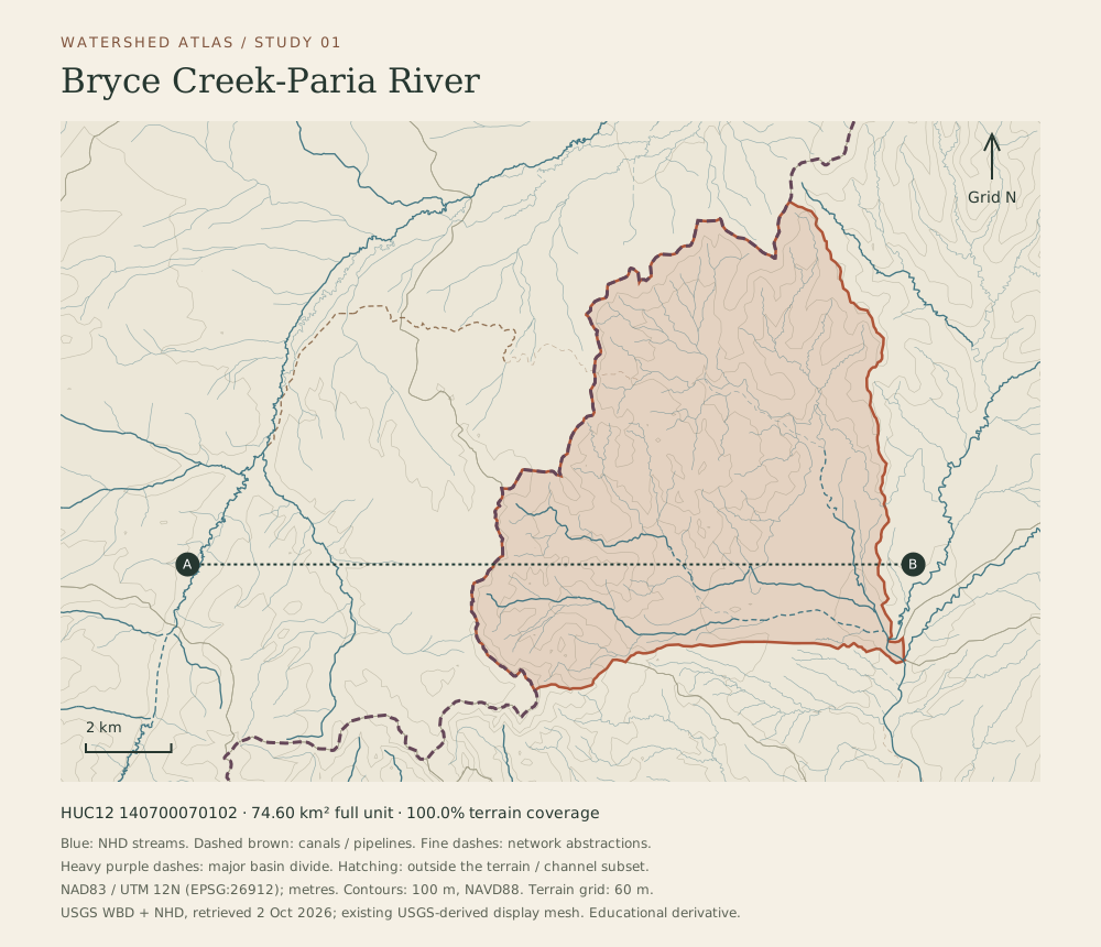
North-up map of HUC12 140700070102. USGS WBD boundary, NHD reference flowlines and terrain-derived 100 metre contours. 100.0 percent of this unit lies within terrain coverage. A–B marks the paired section. This is not a water availability or navigation map.
Derived source data and original BCC cartography. Keep the sampling, source coverage and scale notes printed inside this sheet.
Bryce Creek-Paria River terrain section A–B
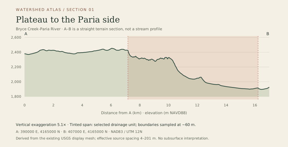
Plateau to the Paria side. Sampled across the existing terrain display mesh at about 60 metre intervals, with 5.1 times vertical exaggeration. Shading identifies the selected WBD unit, not rock layers.
Derived source data and original BCC cartography. Keep the sampling, source coverage and scale notes printed inside this sheet.
Tropic Reservoir drainage study
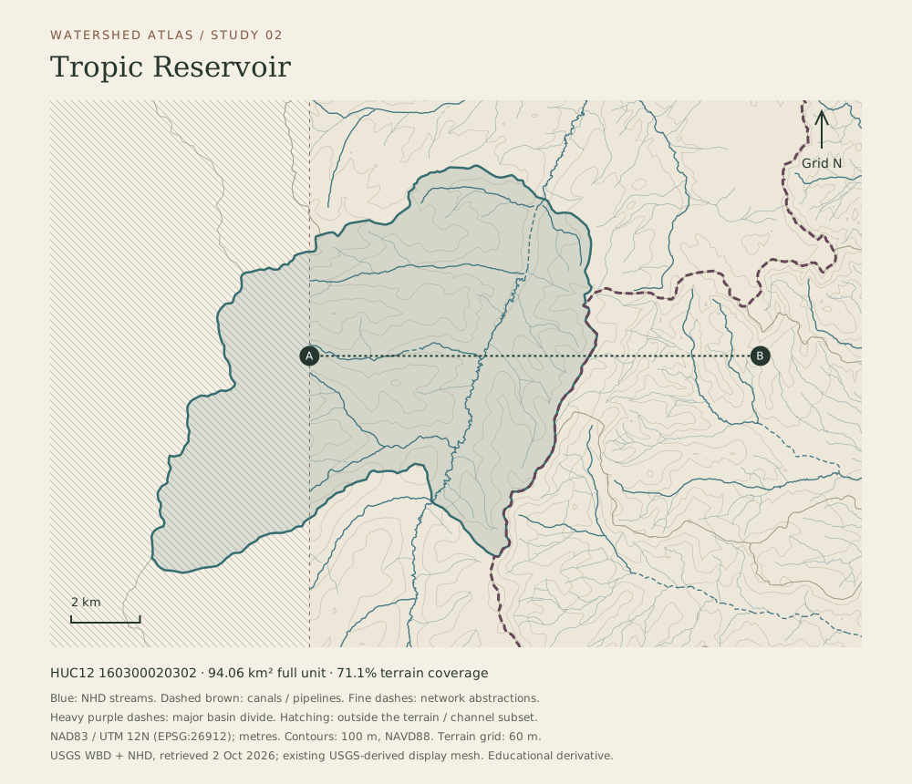
North-up map of HUC12 160300020302. USGS WBD boundary, NHD reference flowlines and terrain-derived 100 metre contours. 71.1 percent of this unit lies within terrain coverage. A–B marks the paired section. This is not a water availability or navigation map.
Derived source data and original BCC cartography. Keep the sampling, source coverage and scale notes printed inside this sheet.
Tropic Reservoir terrain section A–B
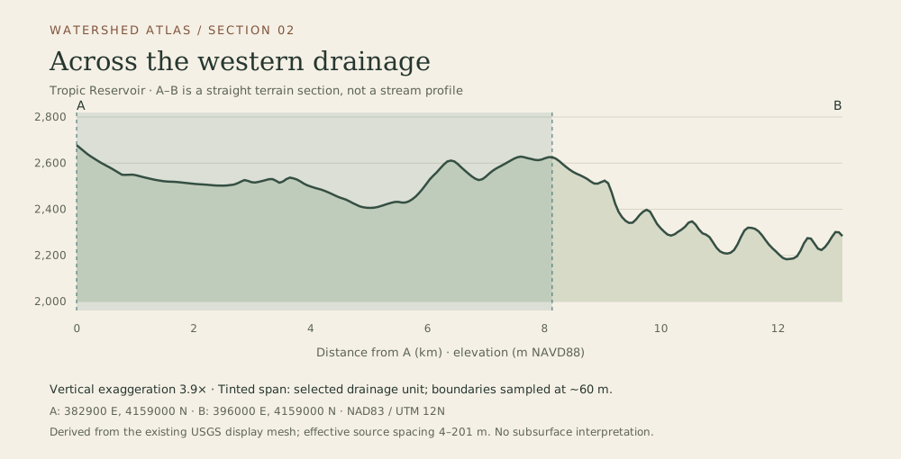
Across the western drainage. Sampled across the existing terrain display mesh at about 60 metre intervals, with 3.9 times vertical exaggeration. Shading identifies the selected WBD unit, not rock layers.
Derived source data and original BCC cartography. Keep the sampling, source coverage and scale notes printed inside this sheet.
Yellow Creek drainage study
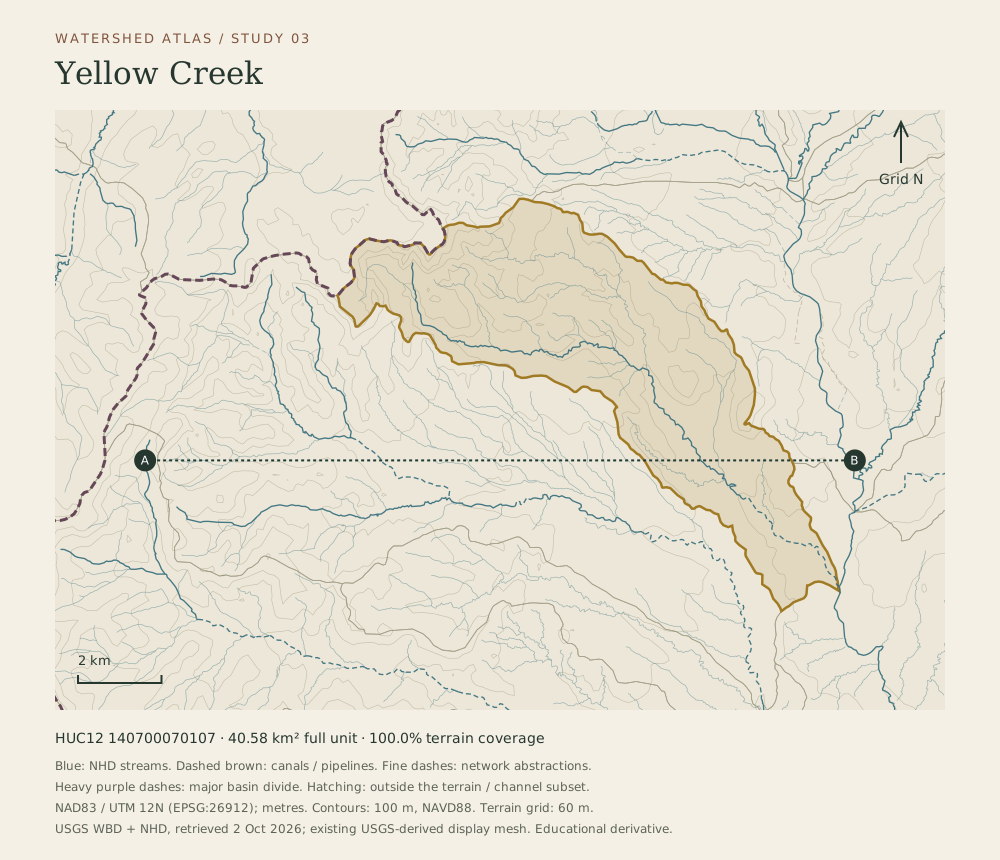
North-up map of HUC12 140700070107. USGS WBD boundary, NHD reference flowlines and terrain-derived 100 metre contours. 100.0 percent of this unit lies within terrain coverage. A–B marks the paired section. This is not a water availability or navigation map.
Derived source data and original BCC cartography. Keep the sampling, source coverage and scale notes printed inside this sheet.
Yellow Creek terrain section A–B
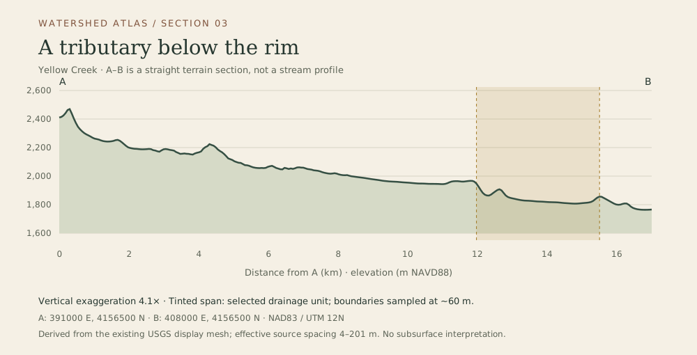
A tributary below the rim. Sampled across the existing terrain display mesh at about 60 metre intervals, with 4.1 times vertical exaggeration. Shading identifies the selected WBD unit, not rock layers.
Derived source data and original BCC cartography. Keep the sampling, source coverage and scale notes printed inside this sheet.
Upper Sheep Creek drainage study
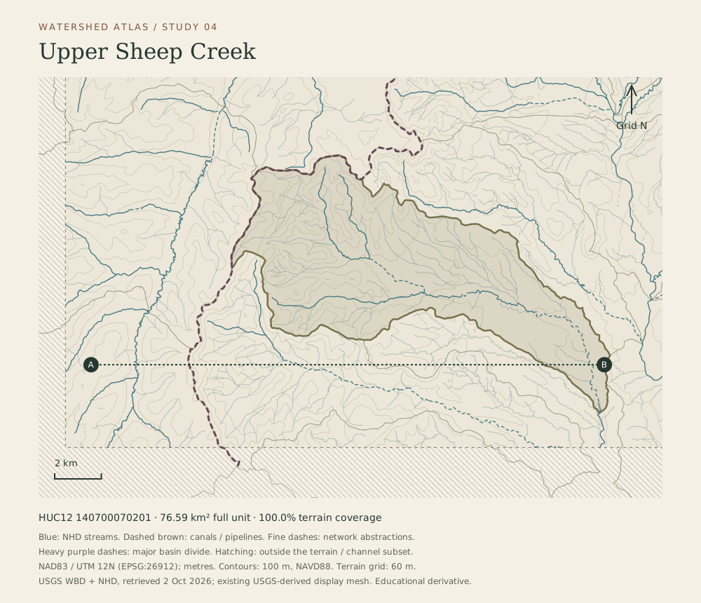
North-up map of HUC12 140700070201. USGS WBD boundary, NHD reference flowlines and terrain-derived 100 metre contours. 100.0 percent of this unit lies within terrain coverage. A–B marks the paired section. This is not a water availability or navigation map.
Derived source data and original BCC cartography. Keep the sampling, source coverage and scale notes printed inside this sheet.
Upper Sheep Creek terrain section A–B
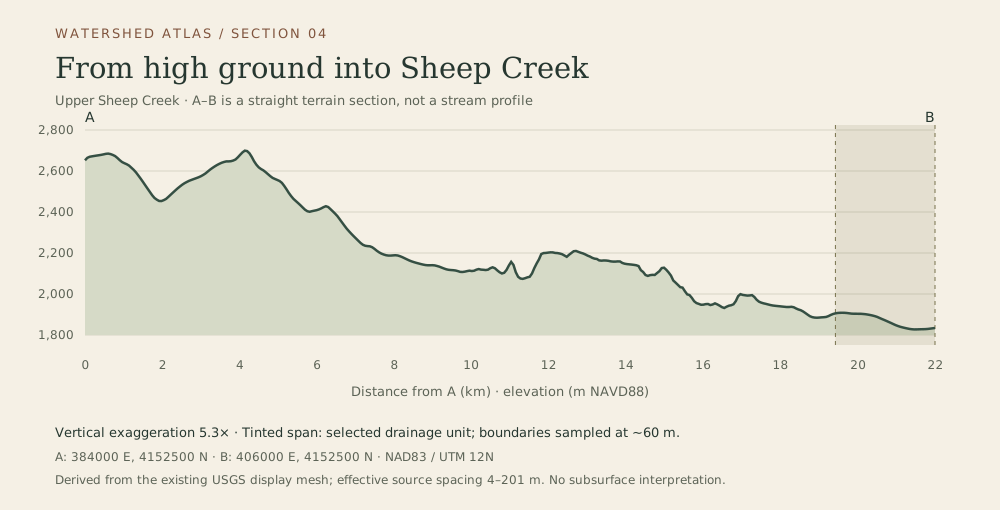
From high ground into Sheep Creek. Sampled across the existing terrain display mesh at about 60 metre intervals, with 5.3 times vertical exaggeration. Shading identifies the selected WBD unit, not rock layers.
Derived source data and original BCC cartography. Keep the sampling, source coverage and scale notes printed inside this sheet.
Keep the source limits.
The Tropic Reservoir study outlines a drainage unit, not the water surface. Hatched or blank areas mark missing terrain or channel coverage. Source stream directions do not establish current flow. The terrain is resampled from an existing display mesh; its effective original spacing varies about 4–201 m. Sections preserve their stated vertical exaggeration.
Boundary and hydrography data: USGS WBD and NHD. Terrain: existing USGS-derived display surface. Original BCC rendering and cartography; no agency endorsement or field qualification.
Read exact source identities, rights and processing limits