02 / Teaching guide · Geology · 30 minutes
Read the rock, question the colour
How much history can a coloured band really tell us?
Suggested ages 10–14. Ages and timings are editorial suggestions; adapt to your learners.
Prepare & connect
Read The Claron Formation and print the two plates. Learners need a pencil and a way to mark A, B and C. Define bed (a layer) and formation (a mappable rock body). Colour is optional: letters and patterns carry the same distinctions.
Optional local resource: The Claron Formation. A browser or this printed bundle; no 3D viewer required.
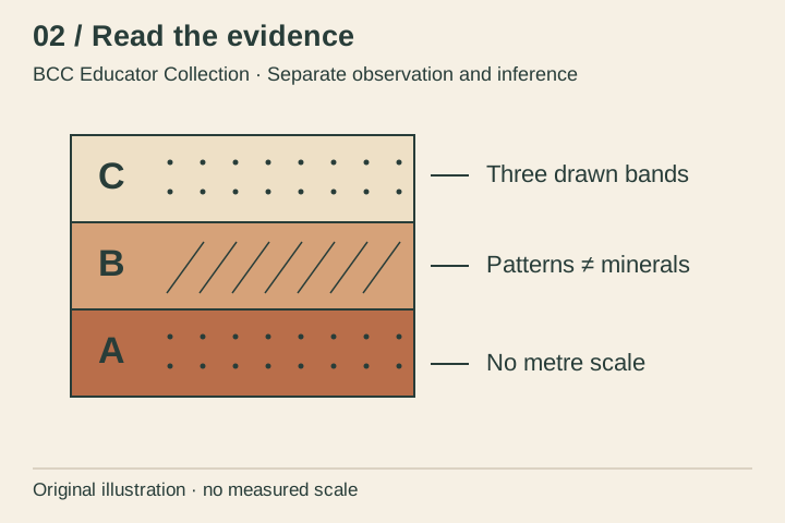
- 5 minDescribe the columnRead the summary from bottom to top. List boundaries, patterns and relative positions. Do not assign a real rock type yet: the three bands are invented for this activity.
- 10 minRead a source carefullyUse the Claron reading and its NPS reference. Note the description of lower pink and upper white members and of mixed depositional materials. Ask why that regional description cannot label every band in our drawing.
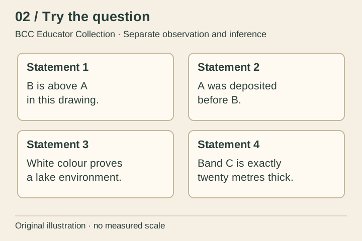
- 10 minSort evidencePlace each activity statement under Observation, Interpretation or Needs more evidence. More than one reason can be defensible; explain which piece of information the statement relies on.
- 5 minImprove a captionReplace ‘This white stripe proves a lake was here’ with a caption that names what is visible, marks the diagram as schematic and asks for a useful next source.
‘B lies above A in the diagram’ is directly visible. ‘A formed first’ needs the assumption of an undisturbed sequence. Colour alone does not prove rock identity or environment. The drawn height has no metre scale, so a claim about thickness in metres is unsupported.
Access: Patterns and letters replace colour matching. Use the statement text as cards, or read the four statements aloud for an oral sort.
02 / Read the evidence · Learner sheet
Read the rock, question the colour
The NPS describes the Claron using lower pink and upper white members, with limestone and varying silt, clay and other interbedded material. Colour is one clue within a larger rock record. A field description or geologic map provides context that a coloured screen image cannot supply.
Look closely
- Which statements can you support by pointing to the drawing alone?
- Would changing the ink colour change the real geological history? Why?
- What could a measured section add that this schematic column leaves out?
Evidence limit: Original illustrative column; no measured thicknesses, sampled rocks, mapped contacts or universal colour-to-rock key.
Reading behind the lesson
- National Park Service · Deciphering Nature’s Palette wayside · 2024-01-08.
- Copied integrated BCC experiences and source registers · 2026-10-02 snapshot.
02 / Try the question · Learner sheet
Separate observation and inference
Sort the four statements on the plate. Then choose the weakest inference and rewrite it with a qualified verb such as suggests. Name the missing evidence. The aim is a defensible explanation, not a guessed rock name.
Take it further: Discuss a tilted or faulted sequence. Which assumptions in a simple bottom-to-top reading would need to be checked?
Success looks like: Ask for evidence that could strengthen a geological interpretation.
All lessons and plates are included in this local copy. Linked experiences are optional. No learner names, responses or locations are collected by this collection.
Save summary plate (SVG) · Save activity plate (SVG)