Case 01 / Terrain / Worksheet
A grid has a blind spot
A terrain model looks convincing. Can it tell you what is beneath an overhang?
Card A · illustrative
One height at each grid location
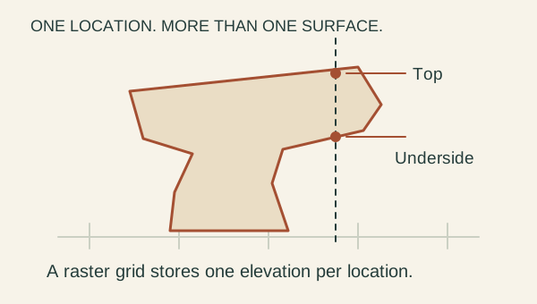
Original schematic of a height grid and an overhang. The rock shape is invented to explain a limitation; it is not Thor’s Hammer or a ground scan.
U.S. Geological Survey
Card B · derived
A real retained terrain product
The Trail Journeys profile uses a 10 m export of the USGS 3DEP bare-earth elevation service, then samples a mapped route. The profile is a derived product.
- Grid spacing
- 10 m
- Horizontal reference
- NAD83 / UTM 12N
- Vertical reference
- NAVD88 metres
- Local trail-height error
- Unknown
U.S. Geological Survey
Card C · reference
What the product promises
USGS defines a DEM as a representation of bare-ground topography. This description does not promise complete walls, cavities, vegetation or undersides.
U.S. Geological Survey
Notice: What is directly represented by the grid?
- Every face of every hoodoo.
- A ground-elevation value at each grid location.
- A photograph of the ground today.
Infer: The rendered model fills the space under a rock ledge. What follows?
- The ledge must be solid underneath.
- The real ledge cannot have an underside.
- The underside remains unestablished by this grid.
Test: What evidence would address that missing surface?
- A ground scan with documented coverage of the underside.
- A smoother mesh made from the same grid.
- A higher-resolution color texture.
What remains unknown? _______________________________________________________
Reasoning notes for case 01 →
Case 02 / Terrain / Worksheet
One view leaves things hidden
Study an archival photograph of Thor’s Hammer. Separate visible detail from a claim about the whole formation.
Card A · reference
Thor’s Hammer at sunrise
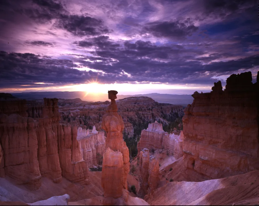
Archival NPS Gallery photograph, asset 6332472a-155d-451f-6738-af9012580dbf. Public domain; no individual photographer named in the retained record. The existing 900 px derivative is reused unchanged.
NPS Gallery
Card B · reference
What accompanies this copy
The retained rights record identifies the original as 1857 × 1479 pixels. It supplies no camera focal length or surveyed scale. The capture date is not securely established by the conflicting metadata date fields.
- Rights
- Public domain
- Camera focal length
- Not supplied
- Surveyed scale
- Not supplied
- Current conditions
- Not established
NPS Gallery
Card C · illustrative
The far side is out of view
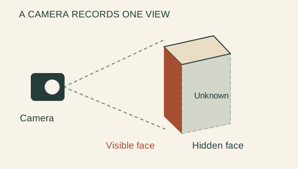
An original visibility diagram distinguishes the visible face from the occluded face. It is not a reconstruction of this hoodoo.
BCC original
Notice: Which statement stays closest to the photograph?
- This view shows a narrow column below a wider top.
- The narrowest part is exactly two metres wide.
- These are the clouds over Bryce right now.
Infer: What can this single view establish about the hidden side?
- The hidden side must mirror the visible side.
- It leaves the hidden side unresolved.
- Nothing useful can be learned from this photograph.
Test: Which next step best supports a complete geometric model?
- Paint plausible detail onto the hidden face.
- Enlarge the same image until more pixels appear.
- Obtain authorized ground coverage and validate scale and alignment.
What remains unknown? _______________________________________________________
Reasoning notes for case 02 →
Case 03 / Terrain / Worksheet
A decimal is not an error bar
The same Navajo Loop data can produce a dramatic profile and several ascent totals. Read the method before trusting the precision.
Card A · derived
Same heights, different drawing scale
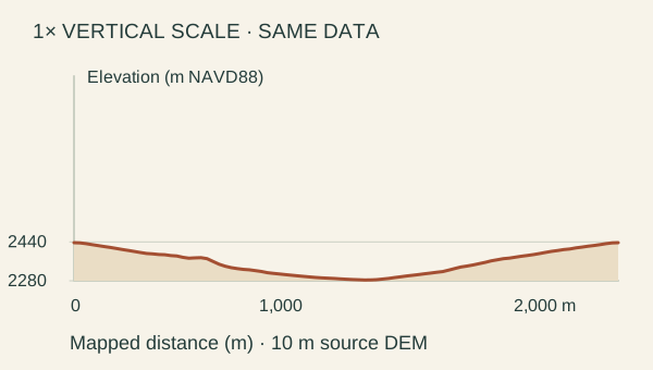
Both views use the retained smoothed Navajo profile. Switching vertical exaggeration changes the picture, not the underlying elevations or ascent.
National Park Service · U.S. Geological Survey
Card B · derived
Retained ascent calculations
These totals come from the same route packet. They measure sensitivity to processing, not a known interval containing the true trail ascent.
- Raw sampled profile
- 176.6 m
- Smoothed, ≤25 m intervals
- 155.6 m
- Smoothed, ≤50 m intervals
- 150.6 m
- Underlying DEM export
- 10 m grid
National Park Service · U.S. Geological Survey
Card C · reference
Error can enter before drawing
The source packet gives no local trail-height error bound. A mapped line beside a cliff can sample adjacent ground instead of the tread. The one-decimal output is only rounding.
U.S. Geological Survey · National Park Service
Notice: What changes when you switch from 1× to 4× vertical exaggeration?
- The real climb becomes four times greater.
- The elevations become four times more accurate.
- The drawn vertical scale changes.
Infer: Does a displayed ascent of 155.6 m imply an error of at most 0.1 m?
- No. The decimal does not establish accuracy.
- Yes, because one decimal place is shown.
- Yes, if the answer lies between the two other totals.
Test: What would most improve an accuracy claim?
- Round to a whole metre and declare it accurate.
- Compare with independent trail measurements and audit the sampling method.
- Average the three totals and call that the measured ascent.
What remains unknown? _______________________________________________________
Reasoning notes for case 03 →
Case 04 / Routes / Worksheet
A line is not an opening report
A saved map draws a complete Navajo Loop. Decide which questions the line can answer.
Card A · derived
Navajo Loop, retained centerline
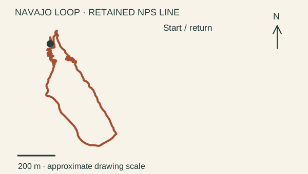
Original north-up drawing from the retained NPS trail geometry. This is a map study, not a navigation product or an opening report.
National Park Service
Card B · reference
Published route context
The NPS route page describes Wall Street and Two Bridges. Wall Street has a seasonal winter closure. This general statement does not resolve access on a particular day.
- Feature type
- Mapped trail centerline
- Live closure feed
- None
- Surface inspection
- None
National Park Service
Card C · reference
A retained snapshot
The BRCA trail extract was retained on 2 October 2026. Selected source edits date to 2021; acquisition dates and positional accuracy are often unknown. Retrieval is not field inspection.
National Park Service
Notice: What does the continuous line directly establish?
- The dataset represents a connected itinerary.
- Every part is open today.
- Every part is free of snow or damage.
Infer: The page was retrieved recently. Does that date the trail’s condition?
- Yes. A new download is a new field observation.
- No. Retrieval, source edits and field conditions have separate dates.
- No, so the entire route must be closed.
Test: Which source is most relevant before making an access decision?
- A smoother drawing of the same line.
- An undated photo of people on the trail.
- Current NPS alerts and route-specific condition information.
What remains unknown? _______________________________________________________
Reasoning notes for case 04 →
Case 05 / Routes / Worksheet
Two distances need two labels
For Queen’s Garden, the mapped itinerary is shorter than the published hike. Keep the disagreement visible.
Card A · derived
Two different kinds of distance
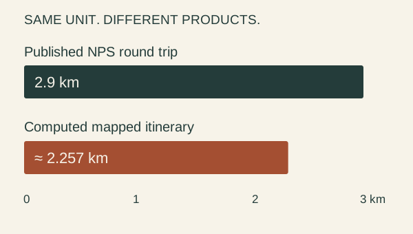
The original comparison graphic displays the NPS published round trip and the retained route calculation. The bars begin at zero and share one kilometre scale.
National Park Service · Utah Geospatial Resource Center (UGRC), WFRC
Card B · derived
What was actually calculated
The source packet sums great-circle lengths between mapped vertices, from the Sunrise junction to the mapped viewing spur and back. It is not a slope-distance survey.
- NPS published round trip
- 2.9 km
- Computed mapped itinerary
- 2,256.733 m
- Difference from 2.9 km
- About 22.2% shorter
- Cause of difference
- Not established
Utah Geospatial Resource Center (UGRC), WFRC
Card C · illustrative
Scope can differ
Generalized bends, selected endpoints and itinerary scope are possible explanations to investigate. This card does not establish which explanation caused this difference.
BCC original
Notice: What does the evidence actually show?
- The two distances are equal after converting units.
- A newly discovered shortcut exists.
- A published total and a derived total differ.
Infer: Which label is defensible for 2,256.733 m?
- Computed length of this selected mapped itinerary.
- Exact distance a visitor will walk.
- A verified correction to the NPS hike distance.
Test: How should the difference be investigated?
- Stretch the polyline until it totals 2.9 km.
- Compare endpoints, route variants, methods and source geometry.
- Average the two values and discard their sources.
What remains unknown? _______________________________________________________
Reasoning notes for case 05 →
Case 06 / Routes / Worksheet
A point has a job
A pin named Queen Victoria Hoodoo Viewpoint is close to a trail endpoint. Is it the hoodoo itself?
Card A · derived
Point → display position
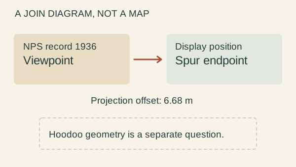
An original relationship diagram shows the documented source point and its projection to the mapped spur. This is a join diagram, not a geographic map or a walking connection.
National Park Service · Utah Geospatial Resource Center (UGRC), WFRC
Card B · reference
NPS record 1936
The retained record is named Queen Victoria Hoodoo Viewpoint. Its point type is “Vicinity point”, map method “Digitized”, and positional-accuracy field “Scaled”.
- Record role
- Viewpoint
- Source object
- 1936
- Projection offset
- 6.68 m (derived)
- Formation geometry
- Not supplied
National Park Service
Card C · reference
Join, not substitution
The packet explicitly projects the published viewpoint to a mapped spur endpoint and reports the offset. The NPS hike page describes viewing the named formation from a short spur.
National Park Service · National Park Service
Notice: Which feature does the source record identify?
- A surveyed summit of the hoodoo.
- A named viewpoint in the vicinity of the formation.
- A parking-space entrance.
Infer: What does the 6.68 m offset mean?
- The source survey is known to be wrong by 6.68 m.
- There is an authorized 6.68 m walking link.
- The displayed route position differs from the retained source point.
Test: What is the best way to carry this point into another exhibit?
- Keep its source ID, viewpoint role, original location and join method.
- Rename it Queen Victoria summit and move it onto the rock.
- Keep only the nearest coordinate and drop the label.
What remains unknown? _______________________________________________________
Reasoning notes for case 06 →
Case 07 / Sky / Worksheet
Above which horizon?
A calculation puts the Moon above zero degrees. Try a hypothetical ridge and see what remains unknown.
Card A · illustrative
Try a counterexample skyline
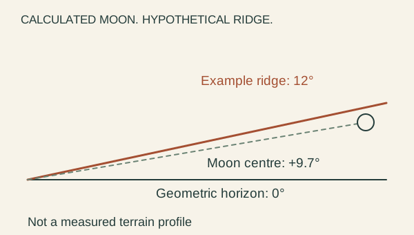
The Moon’s +9.7° altitude is rounded from the retained JPL calculation. The ridge angle is a teaching control, not a measured Bryce skyline. Refraction and the Moon’s apparent radius are omitted.
NASA Jet Propulsion Laboratory, Solar System Dynamics
Card B · derived
Archived model example
NASA/JPL Horizons, airless observer table at the published Sunset Point longitude and latitude. The retained calculation assumes zero ellipsoid height, not the actual site elevation.
- UTC instant
- 2026-06-04 07:00
- Moon-centre altitude
- +9.66338°
- Azimuth (north = 0°)
- 131.382126°
- Skyline measurement
- Not included
NASA Jet Propulsion Laboratory, Solar System Dynamics · National Park Service, National Geospatial Program
Card C · illustrative
A deliberately missing input
At a hypothetical 12° ridge in the same direction, the Moon’s centre is about 2.3° below that ridge. This conditional comparison does not claim that such a ridge exists at Sunset Point.
BCC original
Notice: What does +9.66338° refer to?
- Calculated altitude above the mathematical horizon.
- Measured clearance above the local ridge.
- The Moon’s height above the ground in metres.
Infer: Can a positive altitude guarantee a visible Moon?
- Yes. Zero degrees is always the visible skyline.
- No. Obstructions and viewing conditions are still missing.
- No. The Moon can never be visible from this location.
Test: What additional input addresses the geometric visibility question?
- The phase percentage alone.
- A larger icon for the Moon.
- A measured skyline at that azimuth, with a suitable observer model.
What remains unknown? _______________________________________________________
Reasoning notes for case 07 →
Case 08 / Sky / Worksheet
Moonlight is not a forecast
Compare two archived calculations. What can an illumination percentage help explain, and what can it not promise?
Card A · derived
Two dated model outputs
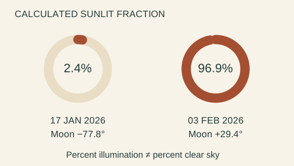
Original graphic from the retained JPL tables. The circles compare sunlit fractions numerically; they are not oriented photographs of the lunar surface.
NASA Jet Propulsion Laboratory, Solar System Dynamics · NASA
Card B · derived
2026-01-17 · 07:00 UTC
Same fixed longitude/latitude and zero-ellipsoid-height assumption as the other sky cases. These are archived calculations, not live observations.
- Illuminated fraction
- 2.43651%
- Moon altitude
- −77.771649°
- Sun altitude
- −71.139938°
NASA Jet Propulsion Laboratory, Solar System Dynamics
Card C · derived
2026-02-03 · 13:00 UTC
This example places a strongly illuminated Moon above the mathematical horizon. No cloud cover, haze, ground obstruction or brightness measurement is included.
- Illuminated fraction
- 96.89523%
- Moon altitude
- +29.440693°
- Sun altitude
- −18.210857°
NASA Jet Propulsion Laboratory, Solar System Dynamics
Notice: What does the illumination percentage describe?
- The percentage of cloud-free sky.
- The percentage of maximum sky brightness at Bryce.
- The calculated sunlit fraction of the apparent lunar disc.
Infer: Which comparison is best supported?
- The February example has a bright-phase Moon above the model horizon.
- The January sky was guaranteed to reveal every faint star.
- The February example proves clear weather.
Test: What would you add to assess a particular observing opportunity?
- Repeat the same phase calculation until it is certain.
- Dated weather, local obstructions and observations of sky quality.
- Treat a Moon calendar as a record of sightings.
What remains unknown? _______________________________________________________
Reasoning notes for case 08 →
Case 09 / Sky / Worksheet
Read the angle before the label
At one archived instant, the Sun’s centre is about 9.8 degrees below the horizon. Classify the geometry without turning it into a visibility promise.
Card A · illustrative
Twilight thresholds
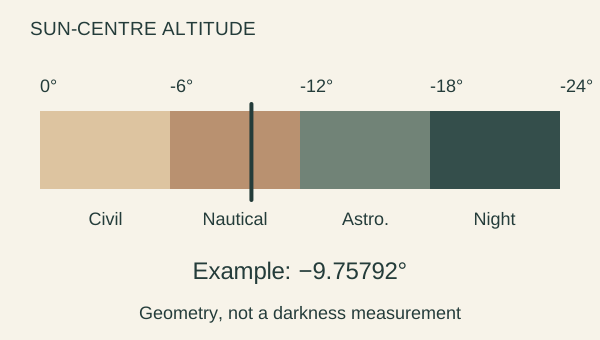
Original angle scale using NOAA/NWS definitions: civil twilight ends at −6°, nautical at −12°, and astronomical at −18° in the evening. Morning reverses the sequence.
NOAA National Weather Service
Card B · derived
A retained JPL Sun calculation
Airless Sun-centre altitude at the fixed example site. Values are calculations; the actual visible horizon and atmospheric effects are not included.
- UTC instant
- 2026-12-11 01:00
- Sun-centre altitude
- −9.75792°
- Sun azimuth
- 248.429225°
NASA Jet Propulsion Laboratory, Solar System Dynamics
Card C · reference
The date belongs to the model
This is a selected future model instant relative to the activity’s 2 October 2026 source review. It is not a report that these conditions were observed.
NASA Jet Propulsion Laboratory, Solar System Dynamics
Notice: Which band contains −9.75792°?
- Civil twilight: Sun less than 6° below zero.
- Nautical twilight: between 6° and 12° below zero.
- Beyond astronomical twilight: more than 18° below zero.
Infer: Which statement preserves the model’s scope?
- All faint stars are visible then.
- Someone measured a dark sky at that time.
- The calculated solar angle falls in the nautical category.
Test: How could you evaluate the actual darkness of the sky?
- Use an appropriately documented sky-brightness observation.
- Rename the category “perfect stargazing”.
- Remove UTC so the time looks local.
What remains unknown? _______________________________________________________
Reasoning notes for case 09 →
Case 10 / Life / Worksheet
A species list is not a census
Three names appear on a park’s mammals page. Keep presence, abundance and a visitor’s experience separate.
Card A · reference
Selected published park entries
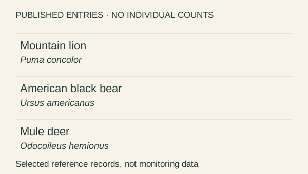
Three entries selected from the NPS Bryce mammals page. This is a publication excerpt presented as a new reference card, not a monitoring dataset or a complete inventory.
National Park Service, Bryce Canyon
Card B · illustrative
Three distinct questions
Does a publication document the species in the park? How many individuals are there? Will a visitor see one? These questions require different evidence.
- Occurrence context
- Park-level publication
- Individual count
- Not provided
- Detection effort
- Not provided
- Sighting prediction
- Not provided
BCC original
Card C · illustrative
A hypothetical non-detection
Thought experiment only: imagine not seeing a listed species during a short visit. No real visitor or wildlife monitoring record is being reported.
BCC original
Notice: What do these three selected entries directly provide?
- Published park-level records naming three taxa.
- A count of three individual animals.
- Evidence of equal populations of the three species.
Infer: In the thought experiment, no animal is seen. What follows?
- The species is absent from the park.
- That hypothetical visit would not resolve park-wide presence or abundance.
- The population must have declined.
Test: What evidence belongs behind a population estimate?
- The number of rows on the web page.
- The number of people who view the page.
- An appropriately designed study that accounts for effort and detectability.
What remains unknown? _______________________________________________________
Reasoning notes for case 10 →
Case 11 / Life / Worksheet
Two names are not two animals
Two linked NPS pages use different scientific names for mountain lion. Decide what can be joined and what must be retained.
Card A · reference
Compare the linked records
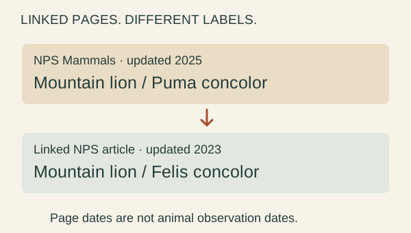
The NPS Mammals page lists mountain lion as Puma concolor and links to the Mountain Lion article, whose scientific-name field reads Felis concolor. These page fields were checked on 2 October 2026.
National Park Service, Bryce Canyon · National Park Service, Bryce Canyon
Card B · reference
Version context matters
The retained Mammals page says it was updated 2 April 2025; the Mountain Lion article says 14 February 2023. These are page dates, not wildlife observation dates.
- Shared common name
- Mountain lion
- List spelling
- Puma concolor
- Article spelling
- Felis concolor
- Individual identities
- None
National Park Service, Bryce Canyon · National Park Service, Bryce Canyon
Card C · illustrative
An identity decision
The integrated catalogue uses Puma concolor and retains Felis concolor as an alias, with a note explaining the linked NPS records. A general text-matching rule would need stronger checks.
BCC original
Notice: What is the discrepancy here?
- The pages count two individual mountain lions.
- A new species was observed in 2025.
- Two linked reference records use different genus names for their mountain-lion subject.
Infer: Which treatment best preserves provenance?
- Retain both source labels and document the adopted identity and alias.
- Rewrite the older source record so the discrepancy vanishes.
- Always merge any two records with a similar common name.
Test: What would strengthen a general-purpose taxonomic join?
- Choose whichever name has the larger heading.
- Check a current taxonomic authority and retain stable identifiers and synonyms.
- Add one animal to the population for every name found.
What remains unknown? _______________________________________________________
Reasoning notes for case 11 →
Case 12 / Life / Worksheet
A habitat is not a pin
Bryce’s life zones describe broad ecological patterns. See why a colored band cannot promise a species at one location.
Card A · illustrative
Broad life-zone ordering
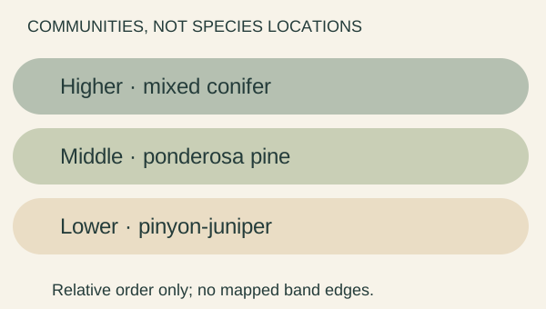
Original teaching diagram after the NPS Bryce Life Zones wayside. Bands show relative ordering only. They have no exact elevation boundaries, coordinates or surveyed widths.
National Park Service, Bryce Canyon
Card B · reference
What the wayside describes
NPS relates the three broad communities to changes in elevation, temperature and precipitation. A life-zone description is not an inventory of every organism at every point.
- Spatial scope
- Broad community pattern
- Exact zone boundaries
- Not supplied here
- Species-level point records
- Not supplied
- Sensitive locations
- Not used
National Park Service, Bryce Canyon
Card C · illustrative
Test the scale of the claim
A claim about a region is not automatically a claim about every location inside it. The colored illustration adds no field observations.
BCC original
Notice: What ordering does the cited wayside support?
- Every tree species has a precise, non-overlapping elevation band.
- Pinyon-juniper lower, ponderosa pine middle, mixed conifer higher.
- Every part of the park has the same habitat.
Infer: Can a point inside the middle band guarantee a ponderosa pine at that point?
- Yes. The band is named for the tree.
- No. The tree cannot occur anywhere in that band.
- No. Broad association does not establish point-level occurrence.
Test: What would address a specific vegetation question?
- A suitably documented local habitat or vegetation observation.
- Zoom the illustrative bands until they look like a detailed map.
- Place a wildlife pin at the centre of each colored band.
What remains unknown? _______________________________________________________
Reasoning notes for case 12 →
Case 01 / Terrain / Reasoning notes
A grid has a blind spot
A height grid can describe a surface without describing every surface of a rock.
1. What is directly represented by the grid?
- A · Not supported: Every face of every hoodoo.
- A raster height surface cannot store several surfaces at the same horizontal location.
- B · Supported: A ground-elevation value at each grid location.
- That is the information a gridded bare-earth product carries. Its coverage and accuracy still need metadata.
- C · Not supported: A photograph of the ground today.
- Elevation values are not photographs, and a retrieval date is not an observation date.
2. The rendered model fills the space under a rock ledge. What follows?
- A · Not supported: The ledge must be solid underneath.
- A renderer can fill an area because its representation has no way to encode the gap.
- B · Not supported: The real ledge cannot have an underside.
- Missing geometry is a limitation of this representation, not evidence that a physical surface is absent.
- C · Supported: The underside remains unestablished by this grid.
- A plausible visible surface does not supply the unobserved underside. The schematic is a counterexample.
3. What evidence would address that missing surface?
- A · Supported: A ground scan with documented coverage of the underside.
- The needed measurement must actually see the surface. Coverage, scale and registration still require checks.
- B · Not supported: A smoother mesh made from the same grid.
- Interpolation changes appearance; it does not introduce observations of previously unseen surfaces.
- C · Not supported: A higher-resolution color texture.
- Color detail does not establish missing three-dimensional geometry.
← Worksheet 01
Case 02 / Terrain / Reasoning notes
One view leaves things hidden
A photograph is evidence of a particular view. A complete shape needs evidence from more than one view.
1. Which statement stays closest to the photograph?
- A · Supported: This view shows a narrow column below a wider top.
- The visible silhouette supports that description from this viewpoint; it does not reveal every side.
- B · Not supported: The narrowest part is exactly two metres wide.
- Without calibrated scale and viewing geometry, an exact physical width cannot be recovered from this card.
- C · Not supported: These are the clouds over Bryce right now.
- This is an archival photograph. Reusing it today does not make it a current observation.
2. What can this single view establish about the hidden side?
- A · Not supported: The hidden side must mirror the visible side.
- Symmetry is an assumption. Different hidden shapes can produce the same visible outline.
- B · Supported: It leaves the hidden side unresolved.
- Occlusion withholds information. An attractive reconstruction may be an interpretation rather than a measured surface.
- C · Not supported: Nothing useful can be learned from this photograph.
- The visible face and lighting are useful visual evidence, even though they do not answer every geometric question.
3. Which next step best supports a complete geometric model?
- A · Not supported: Paint plausible detail onto the hidden face.
- That creates illustrative detail. It must not be reported as a recovered observation.
- B · Not supported: Enlarge the same image until more pixels appear.
- More output pixels do not reveal the face the camera never saw.
- C · Supported: Obtain authorized ground coverage and validate scale and alignment.
- Additional measured views can constrain geometry. This activity does not provide or replace the required ground scan.
← Worksheet 02
Case 03 / Terrain / Reasoning notes
A decimal is not an error bar
Display precision, sampling sensitivity and measured accuracy are three different things.
1. What changes when you switch from 1× to 4× vertical exaggeration?
- A · Not supported: The real climb becomes four times greater.
- The transform acts on the drawing. The physical landscape and the data values remain the same.
- B · Not supported: The elevations become four times more accurate.
- Visual magnification is not an accuracy improvement.
- C · Supported: The drawn vertical scale changes.
- A unit of elevation occupies four times as much screen space relative to a unit of horizontal distance.
2. Does a displayed ascent of 155.6 m imply an error of at most 0.1 m?
- A · Supported: No. The decimal does not establish accuracy.
- Rounding is independent of source error, route placement and processing. None supplies a local ±0.1 m guarantee.
- B · Not supported: Yes, because one decimal place is shown.
- Numerical precision can greatly exceed the accuracy of the observations behind it.
- C · Not supported: Yes, if the answer lies between the two other totals.
- A sensitivity range is not a statistical confidence interval or a validated bound on truth.
3. What would most improve an accuracy claim?
- A · Not supported: Round to a whole metre and declare it accurate.
- Coarser display may communicate caution, but it does not validate the underlying calculation.
- B · Supported: Compare with independent trail measurements and audit the sampling method.
- Independent reference measurements and documented errors can test a claim that repeated rendering cannot.
- C · Not supported: Average the three totals and call that the measured ascent.
- Combining related calculations does not turn them into independent ground measurements.
← Worksheet 03
Case 04 / Routes / Reasoning notes
A line is not an opening report
Geometry describes where a route is represented. Access and conditions need their own dated evidence.
1. What does the continuous line directly establish?
- A · Supported: The dataset represents a connected itinerary.
- The topology of this selected line closes a loop. Its existence does not describe current trail conditions.
- B · Not supported: Every part is open today.
- A saved centerline contains no live opening report.
- C · Not supported: Every part is free of snow or damage.
- Surface conditions are not encoded by the presence of a line.
2. The page was retrieved recently. Does that date the trail’s condition?
- A · Not supported: Yes. A new download is a new field observation.
- Retrieval dates describe copying. The underlying observations and edits can be much older.
- B · Supported: No. Retrieval, source edits and field conditions have separate dates.
- A useful provenance record distinguishes these dates instead of silently substituting one for another.
- C · Not supported: No, so the entire route must be closed.
- Lack of opening evidence establishes uncertainty, not closure.
3. Which source is most relevant before making an access decision?
- A · Not supported: A smoother drawing of the same line.
- That only changes the visualization.
- B · Not supported: An undated photo of people on the trail.
- Past use cannot establish present access.
- C · Supported: Current NPS alerts and route-specific condition information.
- Use dated official access information and its scope. This educational snapshot cannot substitute for it.
← Worksheet 04
Case 05 / Routes / Reasoning notes
Two distances need two labels
Compare like with like before reconciling numbers. Never invent extra geometry to make a total agree.
1. What does the evidence actually show?
- A · Not supported: The two distances are equal after converting units.
- 2,256.733 m is about 2.257 km, which remains shorter than 2.9 km.
- B · Not supported: A newly discovered shortcut exists.
- A discrepancy between products is not evidence of an actual shortcut.
- C · Supported: A published total and a derived total differ.
- Each number has a source and a scope. The discrepancy is real in these records; its cause is unresolved.
2. Which label is defensible for 2,256.733 m?
- A · Supported: Computed length of this selected mapped itinerary.
- The calculation is tied to its vertices and chosen route. That narrower label is supported.
- B · Not supported: Exact distance a visitor will walk.
- Actual travel, tread geometry and endpoints are not fully captured by this calculation.
- C · Not supported: A verified correction to the NPS hike distance.
- Greater decimal precision does not validate the route’s scope or establish a correction.
3. How should the difference be investigated?
- A · Not supported: Stretch the polyline until it totals 2.9 km.
- That would fabricate geometry solely to match a target number.
- B · Supported: Compare endpoints, route variants, methods and source geometry.
- Those checks can reveal whether the numbers describe the same journey. Preserve both labels until resolved.
- C · Not supported: Average the two values and discard their sources.
- An average conceals the scope difference without explaining it.
← Worksheet 05
Case 06 / Routes / Reasoning notes
A point has a job
Place names, feature roles and geometric joins must remain distinct.
1. Which feature does the source record identify?
- A · Not supported: A surveyed summit of the hoodoo.
- Neither the name nor the record fields describe a summit survey.
- B · Supported: A named viewpoint in the vicinity of the formation.
- The record’s name and type identify its role. A place to view a feature is not the feature itself.
- C · Not supported: A parking-space entrance.
- Parking is a different access role. This record does not identify a parking entrance.
2. What does the 6.68 m offset mean?
- A · Not supported: The source survey is known to be wrong by 6.68 m.
- The difference between a point and a display projection is not a measured survey error.
- B · Not supported: There is an authorized 6.68 m walking link.
- A geometric join does not create a route or authorize access.
- C · Supported: The displayed route position differs from the retained source point.
- The offset documents a transformation. The original point, role and uncertainty remain necessary.
3. What is the best way to carry this point into another exhibit?
- A · Supported: Keep its source ID, viewpoint role, original location and join method.
- Explicit provenance lets a later reader distinguish the published point from the derived display position.
- B · Not supported: Rename it Queen Victoria summit and move it onto the rock.
- That would silently substitute a different feature and invent unsupported geometry.
- C · Not supported: Keep only the nearest coordinate and drop the label.
- A coordinate without its semantic role can be attached to the wrong object.
← Worksheet 06
Case 07 / Sky / Reasoning notes
Above which horizon?
The mathematical horizon and the visible skyline are different boundaries.
1. What does +9.66338° refer to?
- A · Supported: Calculated altitude above the mathematical horizon.
- It is an angular model output for a specified observer and instant, not a skyline observation.
- B · Not supported: Measured clearance above the local ridge.
- No local skyline was supplied to this calculation.
- C · Not supported: The Moon’s height above the ground in metres.
- Degrees are angular units. They are not a linear height.
2. Can a positive altitude guarantee a visible Moon?
- A · Not supported: Yes. Zero degrees is always the visible skyline.
- Nearby terrain and other obstructions can rise above the mathematical horizon.
- B · Supported: No. Obstructions and viewing conditions are still missing.
- The hypothetical ridge demonstrates the logical gap. It is a counterexample, not a field observation.
- C · Not supported: No. The Moon can never be visible from this location.
- Insufficient visibility evidence does not establish permanent invisibility.
3. What additional input addresses the geometric visibility question?
- A · Not supported: The phase percentage alone.
- Illumination does not tell you the height of the local ridge in the Moon’s direction.
- B · Not supported: A larger icon for the Moon.
- Changing a symbol does not change or measure the sight line.
- C · Supported: A measured skyline at that azimuth, with a suitable observer model.
- Compare the same direction and location. Atmospheric conditions and refraction still affect actual viewing.
← Worksheet 07
Case 08 / Sky / Reasoning notes
Moonlight is not a forecast
Phase and position inform an observing question; they do not predict clouds, haze or what a person will detect.
1. What does the illumination percentage describe?
- A · Not supported: The percentage of cloud-free sky.
- The table contains no weather model or cloud observation.
- B · Not supported: The percentage of maximum sky brightness at Bryce.
- Observed sky brightness depends on more than the visible sunlit fraction of the Moon.
- C · Supported: The calculated sunlit fraction of the apparent lunar disc.
- It describes phase geometry, not a weather probability or a measured sky brightness.
2. Which comparison is best supported?
- A · Supported: The February example has a bright-phase Moon above the model horizon.
- Both illumination and altitude support that limited statement. Actual visibility and faint-object detection remain conditional.
- B · Not supported: The January sky was guaranteed to reveal every faint star.
- A low Moon contribution cannot guarantee clear skies, dark adaptation or detection of an object.
- C · Not supported: The February example proves clear weather.
- Celestial geometry can be calculated whether or not clouds obscure the sky.
3. What would you add to assess a particular observing opportunity?
- A · Not supported: Repeat the same phase calculation until it is certain.
- Repetition does not supply missing weather or local obstruction information.
- B · Supported: Dated weather, local obstructions and observations of sky quality.
- These independent inputs address the actual conditions. A prediction and an observation must keep distinct labels.
- C · Not supported: Treat a Moon calendar as a record of sightings.
- A calendar gives calculated events or phases, not evidence that anyone observed them.
← Worksheet 08
Case 09 / Sky / Reasoning notes
Read the angle before the label
A twilight category describes solar geometry. It is not a field measurement of darkness.
1. Which band contains −9.75792°?
- A · Not supported: Civil twilight: Sun less than 6° below zero.
- The magnitude of 9.75792° is greater than 6°.
- B · Supported: Nautical twilight: between 6° and 12° below zero.
- The value lies between the two geometric thresholds.
- C · Not supported: Beyond astronomical twilight: more than 18° below zero.
- The value is not below −18°.
2. Which statement preserves the model’s scope?
- A · Not supported: All faint stars are visible then.
- A twilight label cannot guarantee detection under unknown clouds, haze, light sources or observer conditions.
- B · Not supported: Someone measured a dark sky at that time.
- A numerical ephemeris is not a field observation.
- C · Supported: The calculated solar angle falls in the nautical category.
- This follows from the model output and the category definition without introducing an observation.
3. How could you evaluate the actual darkness of the sky?
- A · Supported: Use an appropriately documented sky-brightness observation.
- A dated, calibrated observation answers a different question from the Sun-angle calculation. Keep weather and method with it.
- B · Not supported: Rename the category “perfect stargazing”.
- A more appealing label supplies no additional evidence.
- C · Not supported: Remove UTC so the time looks local.
- That introduces ambiguity. Preserve the instant and state any local-time conversion explicitly.
← Worksheet 09
Case 10 / Life / Reasoning notes
A species list is not a census
An entry in a published park list does not count individuals or promise a sighting.
1. What do these three selected entries directly provide?
- A · Supported: Published park-level records naming three taxa.
- The entries document what the park page lists. They do not enumerate animals or establish a current location.
- B · Not supported: A count of three individual animals.
- Taxon entries are not individual animal detections.
- C · Not supported: Evidence of equal populations of the three species.
- Equal numbers of rows convey nothing about relative abundance.
2. In the thought experiment, no animal is seen. What follows?
- A · Not supported: The species is absent from the park.
- A short visit with unspecified effort and detectability cannot establish park-wide absence.
- B · Supported: That hypothetical visit would not resolve park-wide presence or abundance.
- Detection depends on effort and circumstances. A non-detection is not automatically evidence of zero population.
- C · Not supported: The population must have declined.
- A trend requires comparable evidence over time, not a comparison between a species list and one hypothetical visit.
3. What evidence belongs behind a population estimate?
- A · Not supported: The number of rows on the web page.
- Page design and species selection are not a sampling design for individual abundance.
- B · Not supported: The number of people who view the page.
- Website traffic does not count wildlife.
- C · Supported: An appropriately designed study that accounts for effort and detectability.
- Expert-reviewed methods can support an estimate and its uncertainty. This activity supplies no such study or monitoring records.
← Worksheet 10
Case 11 / Life / Reasoning notes
Two names are not two animals
Resolve identities with documented references, while preserving the original names and dates.
1. What is the discrepancy here?
- A · Not supported: The pages count two individual mountain lions.
- Neither page field identifies an individual animal.
- B · Not supported: A new species was observed in 2025.
- A page update is not a biological observation or a species description.
- C · Supported: Two linked reference records use different genus names for their mountain-lion subject.
- The link, common name and recorded labels provide the evidence for this specific editorial reconciliation.
2. Which treatment best preserves provenance?
- A · Supported: Retain both source labels and document the adopted identity and alias.
- A reversible, cited mapping avoids double counting and preserves what each source actually said.
- B · Not supported: Rewrite the older source record so the discrepancy vanishes.
- Overwriting the source removes evidence of its original terminology and version.
- C · Not supported: Always merge any two records with a similar common name.
- Common-name resemblance alone is not a reliable taxonomic identity rule.
3. What would strengthen a general-purpose taxonomic join?
- A · Not supported: Choose whichever name has the larger heading.
- Typography is not taxonomic evidence.
- B · Supported: Check a current taxonomic authority and retain stable identifiers and synonyms.
- A documented authority supports a reproducible join; source labels and dates should remain available.
- C · Not supported: Add one animal to the population for every name found.
- Names and reference records are not animal detections or abundance estimates.
← Worksheet 11
Case 12 / Life / Reasoning notes
A habitat is not a pin
A broad habitat association can guide a question without establishing occupancy at a point.
1. What ordering does the cited wayside support?
- A · Not supported: Every tree species has a precise, non-overlapping elevation band.
- The diagram does not define exact species boundaries and supplies no evidence that communities are exclusive.
- B · Supported: Pinyon-juniper lower, ponderosa pine middle, mixed conifer higher.
- This is the broad relative life-zone ordering described by NPS.
- C · Not supported: Every part of the park has the same habitat.
- The cited account explicitly describes contrasting broad communities.
2. Can a point inside the middle band guarantee a ponderosa pine at that point?
- A · Not supported: Yes. The band is named for the tree.
- A community name does not prove occupancy at each point. The schematic is not a tree map.
- B · Not supported: No. The tree cannot occur anywhere in that band.
- Rejecting a guarantee does not establish absence.
- C · Supported: No. Broad association does not establish point-level occurrence.
- The claim changes spatial scale. A local observation would be a separate piece of evidence.
3. What would address a specific vegetation question?
- A · Supported: A suitably documented local habitat or vegetation observation.
- Match the evidence’s spatial scale and method to the question, with permission and sensitivity limits respected.
- B · Not supported: Zoom the illustrative bands until they look like a detailed map.
- Magnification does not create finer source information.
- C · Not supported: Place a wildlife pin at the centre of each colored band.
- That would invent a species location. This pack deliberately contains no such records.
← Worksheet 12
Reference shelf
Sources and limits
Every diagram is an original BCC rendering. Data-derived figures retain their source credit. The photograph is an unchanged existing NPS derivative; the individual asset rights record states public domain. Utah route derivatives retain CC BY 4.0 attribution to UGRC/WFRC and the selected records’ OrbitalView source. No government-hosted photograph is presumed reusable without its own rights record.
- Original evidence-reading exercises — Bryce Canyon Conservancy. Original BCC text and vector illustrations. Editorial reasoning; no invented event is presented as a real observation.
- What is a digital elevation model (DEM)? — U.S. Geological Survey. Primary source. Factual paraphrase; no USGS diagram copied. Definition alone does not establish the resolution or local accuracy of a specific product.
- Thors Hammer at sunrise — NPS Gallery. Primary source. Public domain, explicitly stated in the retained individual asset metadata. No individual photographer credited. Not a measurement, current view or ground scan. Capture date unresolved; metadata dates differ. Rights record retained 2026-09-28 and inspected 2026-10-02.
- Utah Trails and Pathways — Utah Geospatial Resource Center (UGRC), WFRC. Primary source. CC BY 4.0. Credit UGRC/WFRC and the selected records’ OrbitalView source. BCC selected and redrew these data; no source accuracy improvement is claimed. CC BY 4.0 license. State compilation including licensed Orbital View data and NPS revisions. Selected records still identify OrbitalView as their source. No source survey date, intended engineering scale or positional accuracy is supplied for these segments. General overview only.
- NPS public trail centerlines — National Park Service. Primary source. U.S. federal public data; retain NPS disclaimer Partial network in the retrieved BRCA extract. Three social/non-public-note records excluded. Source accuracy is Unknown; publication in this service does not establish current opening.
- USGS 3DEP Bare Earth DEM Dynamic service — U.S. Geological Survey. Primary source. Public domain 10 m bilinear export, NAD83 / UTM 12N; NAVD88 metres under the CONUS 3DEP convention. Mixed source resolutions and dates. Not surveyed trail tread. Profile and ascent errors can be large beside cliffs, bridges or tunnels.
- NPS public points of interest — National Park Service. Primary source. U.S. federal public data; retain NPS disclaimer Named viewpoints and trailheads are separate from terrain, formations and arrival points. Points may be digitized; projected route positions are identified as such.
- Navajo Loop Trail — National Park Service. Primary source. Federal text; no photographs reused Dated published reference; not live conditions. No source photographs reused.
- Queen S Garden Trail — National Park Service. Primary source. Federal text; no photographs reused Dated published reference; not live conditions. No source photographs reused.
- Sunset Point To Sunrise Point Hike — National Park Service. Primary source. Federal text; no photographs reused Dated published reference; not live conditions. No source photographs reused.
- NPS Public Points of Interest — Sunset Point, object 7763 — National Park Service, National Geospatial Program. Primary source. U.S. Government public data; source method NAIP, Harpers Ferry retained. No source imagery copied. Accuracy field is Unknown. The point is not a parking entrance, accessibility assessment, local skyline or access permission.
- Horizons System — observer tables and documented quantities — NASA Jet Propulsion Laboratory, Solar System Dynamics. Primary source. Public NASA/JPL numerical output retained for verification with provenance; no imagery used. Reference rows are samples, not exhaustive error proof. Future Earth orientation is predicted/extrapolated. JPL's topocentric phase is compared with the model's geocentric phase using a 2-percentage-point allowance.
- Moon Phases — NASA. Primary source. Paraphrased explanation; no diagrams or photographs reused. No copied current-phase widget or prediction feed. Full/new labels are approximate neighborhoods, not event times.
- Definitions of Twilight — NOAA National Weather Service. Primary source. Paraphrased geometric definitions; no media reused. This tool calls center altitude >=0 daylight. Actual sunrise/sunset includes limb/refraction and is not calculated.
- Mammals — National Park Service, Bryce Canyon. Primary source. Factual paraphrases only. Third-party photographs on these pages are not licensed or reused by this guide; government hosting is not a photo rights grant. No individual detections, abundance, current sightings or sensitive locations. Page dates are not observation dates.
- Mountain Lion — National Park Service, Bryce Canyon. Primary source. Factual paraphrases only. Third-party photographs on these pages are not licensed or reused by this guide; government hosting is not a photo rights grant. No individual detections, abundance, current sightings or sensitive locations. Page dates are not observation dates.
- Bryce Life Zones wayside — National Park Service, Bryce Canyon. Primary source. Factual paraphrases only. Third-party photographs on these pages are not licensed or reused by this guide; government hosting is not a photo rights grant. No individual detections, abundance, current sightings or sensitive locations. Page dates are not observation dates.