Work on the page at your own pace. All maps are derived teaching diagrams using NPS overlook locators. Dots are not parking or trailhead points; dashed lines are not routes. No field travel is required.
Use your browser’s Print command. Each quest starts on a fresh page; the answer key follows. No JavaScript is needed.
01 / 12 · Relative position
Start at the top
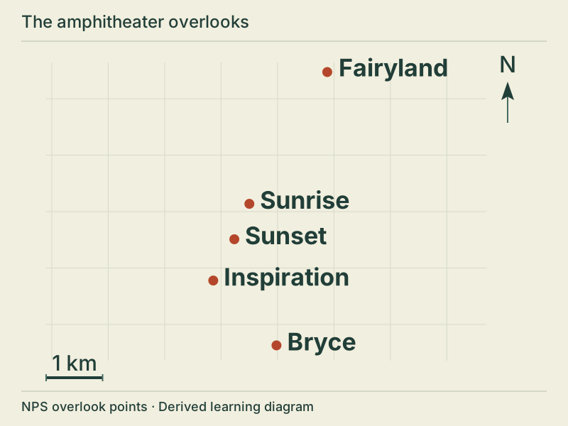
Which of these overlooks is farthest north?
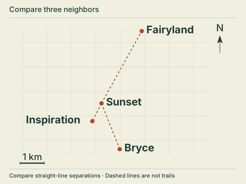
North is up. From north to south: Fairyland, Sunrise, Sunset, Inspiration, Bryce. Each dot is a published overlook, not a parking area.
Bryce
Sunset
Fairyland
Inspiration
My answer and reasoning: __________________________________________
02 / 12 · Direction
Across the page
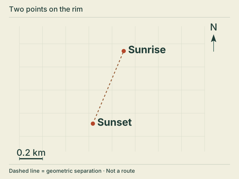
From Sunset toward Sunrise, which compass quadrant do you move into on the map?
North is up. Sunrise lies north and east of Sunset. The dashed line is straight-line separation, not a trail. The scale bar is 0.2 km.
North-east
South-east
South-west
North-west
My answer and reasoning: __________________________________________
03 / 12 · Spatial sequence
Read the rim in order
Which sequence runs from north to south?
North is up. From north to south: Fairyland, Sunrise, Sunset, Inspiration, Bryce. Each dot is a published overlook, not a parking area.
Bryce → Inspiration → Sunset → Sunrise
Sunrise → Sunset → Inspiration → Bryce
Sunset → Sunrise → Bryce → Inspiration
Sunrise → Inspiration → Sunset → Bryce
My answer and reasoning: __________________________________________
04 / 12 · Map rotation
Let the arrow lead
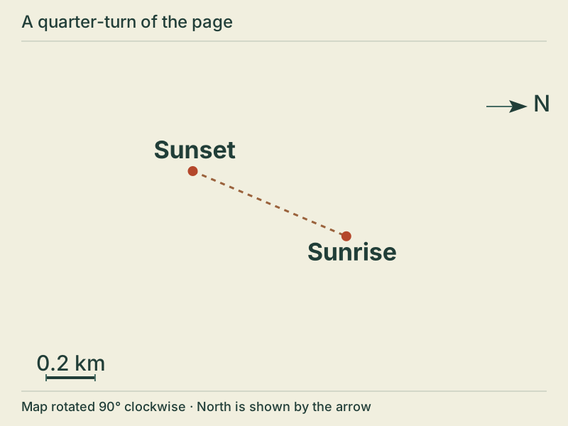
This map was turned 90° clockwise. Which page edge now points north?
The same Sunrise and Sunset geometry, rotated 90 degrees clockwise. The north arrow points to the right edge. Sunrise is right and slightly below Sunset.
Top
Left
Bottom
Right
My answer and reasoning: __________________________________________
05 / 12 · Bearing
Turn clockwise from north
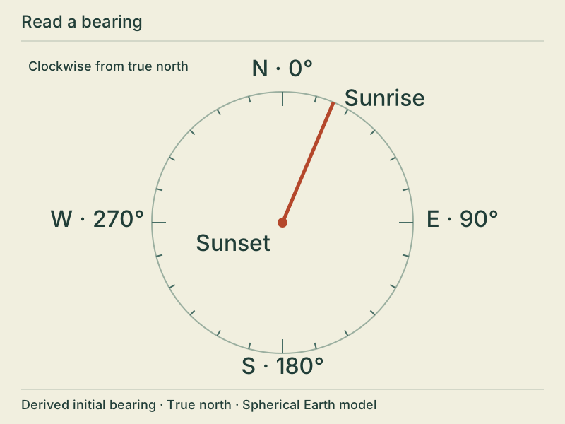
The bearing from Sunset to Sunrise lies in which range?
A compass rose centered on Sunset, with north 0 degrees, east 90, south 180 and west 270. The ray toward Sunrise is about 23 degrees clockwise from north. The rose illustrates a derived spherical initial bearing, not magnetic north.
90°-135°
180°-225°
0°-45°
270°-315°
My answer and reasoning: __________________________________________
06 / 12 · Reverse bearing
Look back
The outward bearing is about 23°. What is the approximate bearing from Sunrise back to Sunset?
A compass rose centered on Sunset, with north 0 degrees, east 90, south 180 and west 270. The ray toward Sunrise is about 23 degrees clockwise from north. The rose illustrates a derived spherical initial bearing, not magnetic north.
23°
203°
113°
337°
My answer and reasoning: __________________________________________
07 / 12 · Nearest point
A nearby neighbor
Of these three overlooks, which has the shortest straight-line separation from Sunset?
Sunset is linked by dashed geometric lines to Inspiration, Bryce and Fairyland. Inspiration is nearest at approximately 0.82 km; Bryce is about 2.02 km and Fairyland about 3.39 km. No connecting route is implied.
Fairyland
Bryce
Inspiration
My answer and reasoning: __________________________________________
08 / 12 · Map scale
Measure with the bar
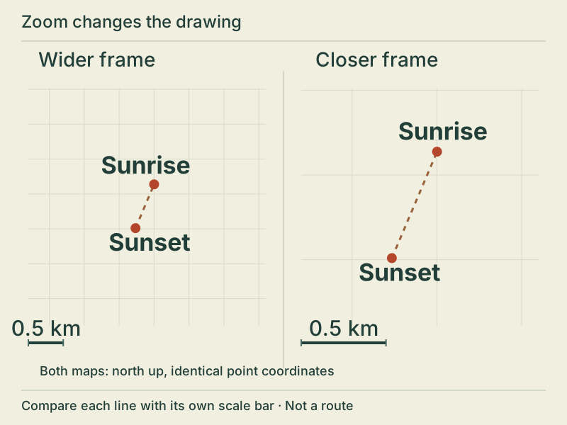
Use either 0.5 km scale bar. About how far apart are Sunrise and Sunset in a straight line?
Two north-up maps show the same Sunrise and Sunset points. The close map draws their separation larger. Each scale bar represents 0.5 km and grows by the same factor as the point separation. Physical separation is unchanged.
0.06-0.08 km
0.6-0.8 km
6-8 km
60-80 km
My answer and reasoning: __________________________________________
09 / 12 · Zoom
Closer on the page
The close map draws the same points farther apart. What happened to their real separation?
Two north-up maps show the same Sunrise and Sunset points. The close map draws their separation larger. Each scale bar represents 0.5 km and grows by the same factor as the point separation. Physical separation is unchanged.
It increased with the drawing
It decreased
It stayed the same
The two points swapped places
My answer and reasoning: __________________________________________
10 / 12 · Facing direction
Behind the view
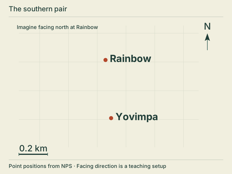
Imagine standing at Rainbow and facing true north. Where is Yovimpa relative to you?
North is up. Yovimpa lies almost due south and slightly east of Rainbow, about 0.4 km away in a straight line. The scale bar is 0.2 km.
Ahead
Directly left
Directly right
Behind you
My answer and reasoning: __________________________________________
11 / 12 · Longitude
East among negative numbers
Longitudes: Fairyland −112.1473°, Sunrise −112.1630°, Rainbow −112.2406°. Which point is farthest east?
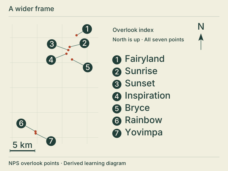
A regional point map, with north up. Numbered points are 1 Fairyland, 2 Sunrise, 3 Sunset, 4 Inspiration, 5 Bryce, 6 Rainbow and 7 Yovimpa. The southern pair is far south and west of the amphitheater group. Number labels identify points; no trail or park boundary is shown.
Rainbow
Fairyland
Sunrise
My answer and reasoning: __________________________________________
12 / 12 · Evidence limits
A line is not a trail
What can the dashed lines between these points establish?
Sunset is linked by dashed geometric lines to Inspiration, Bryce and Fairyland. Inspiration is nearest at approximately 0.82 km; Bryce is about 2.02 km and Fairyland about 3.39 km. No connecting route is implied.
A safe walking shortcut
Current travel time
An approximate straight-line separation
An unobstructed view between overlooks
My answer and reasoning: __________________________________________
Answer key · Follow the reasoning
01. Start at the top · C
Fairyland
Find the north arrow before reading the page.
Compare the vertical positions of the named points.
Fairyland has the greatest latitude of the five: about 37.6492° N.
02. Across the page · A
North-east
Start at Sunset, not at the top of the page.
Sunrise is farther north and slightly farther east.
The vector falls in the north-east quadrant; this is a map comparison, not a walking instruction.
03. Read the rim in order · B
Sunrise → Sunset → Inspiration → Bryce
Use north-up orientation to compare latitudes.
Read Sunrise, then Sunset, then Inspiration, then Bryce.
This orders the point positions only; it does not describe a connected route.
04. Let the arrow lead · D
Right
The arrow is tied to geographic north, not to the page edge.
A clockwise quarter-turn moves the original top toward the right.
Sunrise is still geographically north-east of Sunset, even though the page has turned.
05. Turn clockwise from north · C
0°-45°
A true bearing starts at north, 0°, and increases clockwise.
The Sunrise ray is between north and north-east.
A spherical calculation from the retained point coordinates gives about 23°.
06. Look back · B
203°
Exchange the origin and destination.
Over this short separation, turn approximately 180°: 23° + 180° = 203°.
An independent spherical return calculation is about 202.985°. Long-distance reverse bearings need their own calculation.
07. A nearby neighbor · C
Inspiration
Use Sunset as the common starting point for all three lines.
The shortest line reaches Inspiration: about 0.82 km, versus 2.02 km to Bryce and 3.39 km to Fairyland.
These are point separations. Walking distance, access and travel time require other evidence.
08. Measure with the bar · B
0.6-0.8 km
Read the units on the bar: 0.5 km.
The point separation is about 1.36 times the bar length.
The spherical calculation gives about 0.682 km. This is not trail length or a surveyed distance.
09. Closer on the page · C
It stayed the same
Both panels use exactly the same two source coordinates.
The close panel magnifies both the point separation and the scale bar.
Their ratio stays constant, so the geographic separation stays the same.
10. Behind the view · D
Behind you
NPS describes Rainbow’s northward view; use that as this imagined facing direction.
Yovimpa has a lower latitude and lies almost due south of Rainbow.
Its bearing is about 174.5°: behind you, slightly east (to your right). This does not establish a line of sight.
11. East among negative numbers · B
Fairyland
For these west longitudes, east means a greater value: closer to zero.
−112.1473 is greater than −112.1630 and −112.2406.
Fairyland is farthest east among these three. Source coordinate arrays are ordered [longitude, latitude] in degrees.
12. A line is not a trail · C
An approximate straight-line separation
The endpoints are published overlook locators, with varying or unknown accuracy.
A calculation can compare their positions and approximate separation.
It cannot establish a safe route, current access, travel time or visibility. Use current NPS information for an actual visit.
Where the points come from
Coordinates retain the NPS public POI snapshot retrieved October 2, 2026. The seven source features were edited in 2021 and are published locators with varying or unknown accuracy. Labels use shorter names for legibility. Every feature is an overlook, not an access point.
The maps use a local equirectangular grid with x east and y north, origin 112.18° W / 37.6° N and standard parallel 37.6° N. Distances use a sphere of mean radius 6,371,008.8 m; bearings run clockwise from true north. These are approximate derived relationships, not survey or magnetic-compass instructions.
Original BCC diagrams, code and teaching text. No claim to original U.S. Government works. No photograph, aerial imagery, park logo or third-party basemap is reused. BCC is independent; this activity is not an NPS product or endorsement.