Twelve original studies, a little room for reasoning, and a separate answer key. Use your browser’s Print command for one worksheet per page, followed by three answer pages. You can choose pages 1–12 to print only the questions.
Original teaching drawings inspired by Bryce. Shapes, coordinates and dimensions are invented for these activities; they do not describe surveyed places or routes. There is no timer, score requirement or field task.
Canyon Puzzles · puzzle 01 of 12 · Contours
A hill, seen two ways
Original illustration. Invented geometry, not a surveyed Bryce location.
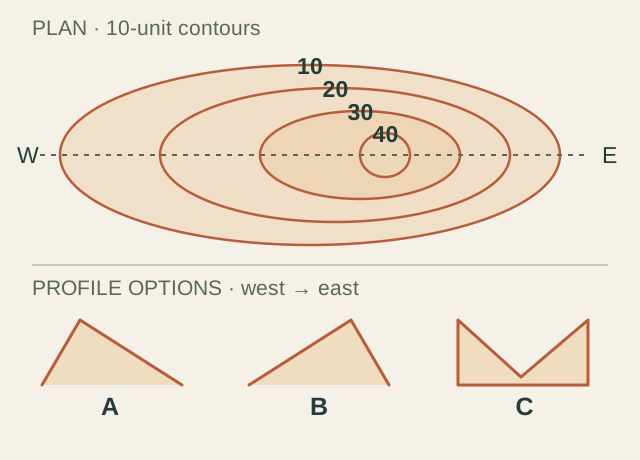
Follow the dashed line from west (W) to east (E). Which profile fits the contours?
A · Steep west side, gentle east side
B · Gentle west side, steep east side
C · A hollow, lowest in the middle
My reasoning:
Assumptions. Each contour is 10 model units higher than the last. The unmarked summit is just inside the 40-unit loop. Profiles are schematic.
Diagram in words & a hint
Four nested contours are labeled 10, 20, 30 and 40. Along the west-to-east center line their west intersections are at 60, 160, 260 and 360; east intersections are at 560, 510, 460 and 410. Profile A climbs steeply on the west; B climbs gently on the west; C is a hollow.
Hint: Compare how far you travel between equal height steps on each side.
Original illustration. Invented geometry, not a surveyed Bryce location.
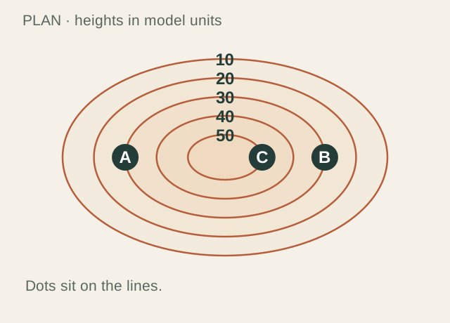
Which two statements are supported by the labeled contour lines? Select both.
A and B have the same elevation.
C is 20 units higher than A.
A and B are 30 units apart horizontally.
C is lower because it is nearer the center.
My reasoning:
Assumptions. Dots sit exactly on the contours. Heights are invented model units, with a 10-unit interval.
Diagram in words & a hint
A and B sit on opposite sides of the same contour, labeled 30. C sits on the innermost contour, labeled 50. Outer contours are 10 and 20; the line between 30 and 50 is 40.
Hint: A contour number describes height, not distance along the line.
Original illustration. Invented geometry, not a surveyed Bryce location.
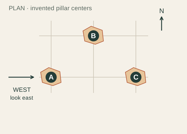
Look east from the west marker. Which two pillar centers line up, one behind the other?
A and B
A and C
B and C
My reasoning:
Assumptions. Use a parallel (orthographic) view: sight lines run due east. Compare centers, not widths or whether a taller top remains visible.
Diagram in words & a hint
A is at east -2, north -1; B at east 0, north 1; C at east 2, north -1. The viewer is west of A, looking due east. A and C have equal north coordinates.
Hint: Draw a straight east–west line through each center.
Original illustration. Invented geometry, not a surveyed Bryce location.
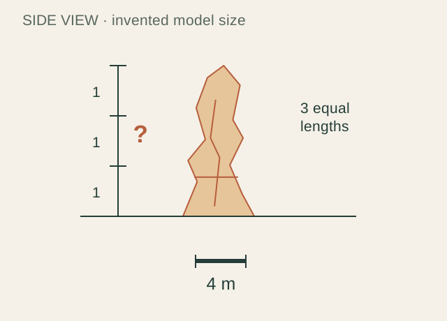
The pillar’s drawn height is three times the length of the 4 m scale bar. How tall is the model pillar?
Model height: ______________ metres
My reasoning:
Assumptions. This is a side-on scale drawing with equal horizontal and vertical scale. The dimension is invented, not a measured Bryce hoodoo.
Diagram in words & a hint
The pillar’s height spans three equal 72-unit drawing intervals, for a total of 216 drawing units. A horizontal bar 72 drawing units long represents 4 metres.
Hint: Each one of the three equal lengths represents 4 metres.
Original illustration. Invented geometry, not a surveyed Bryce location.
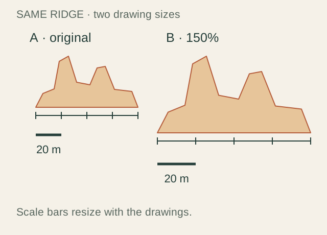
Drawing B is a 150% enlargement of A, including its scale bar. Which two statements are true?
Both drawings represent an 80 m span.
B’s longer printed scale bar still represents 20 m.
The represented ridge grows to 120 m in B.
B reveals newly measured rock detail.
My reasoning:
Assumptions. A and B show the same invented ridge. Both are uniformly scaled, with no cropping or added measurements.
Diagram in words & a hint
Drawing A has a ridge span of 200 drawing units and a 50-unit bar labeled 20 m. B has a 300-unit span and a 75-unit bar also labeled 20 m. B is 150 percent of A.
Hint: Count scale bars across the span in each drawing.
Original illustration. Invented geometry, not a surveyed Bryce location.
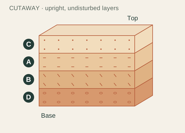
Put the layers in order of deposition, from oldest to youngest. Write the letters in sequence.
C · dotted top layer
A · dashed layer
B · striped layer
D · pebbly base layer
Oldest → youngest:
Assumptions. These four sedimentary layers are undisturbed and have not been overturned. Letters identify invented layers, not named Bryce formations.
Diagram in words & a hint
A cutaway block shows four horizontal layers. From top to bottom they are C with dots, A with dashes, B with stripes, and D with pebble shapes. The block has not been overturned.
Hint: Which layer was already there when the next one was laid on top?
Original illustration. Invented geometry, not a surveyed Bryce location.
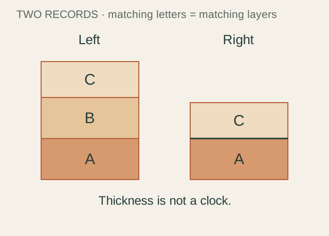
Layer B is missing from the right record. Which two histories could explain this? Select both possibilities.
B formed on the right, then eroded before C was deposited.
B was never deposited on the right.
A must be younger than C on the right.
Exactly one million years is missing on the right.
My reasoning:
Assumptions. The matching A and C layers have already been correlated. Both records are upright. No other evidence about B is available.
Diagram in words & a hint
The left record contains A at the base, B in the middle, and C on top. The right record has A directly beneath C and no B. Equal letters are stipulated to be matching layers; thickness is not a time scale.
Hint: Think about the difference between something removed and something never put down.
Original illustration. Invented geometry, not a surveyed Bryce location.
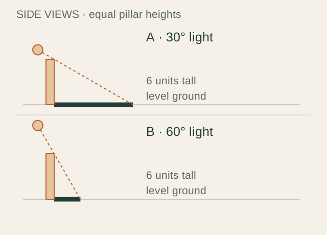
The two model pillars are equally tall. Which light angle makes the longer ground shadow?
A · The lower light at 30°
B · The higher light at 60°
Both shadows have equal length
My reasoning:
Assumptions. Each pillar is vertical and 6 model units tall, on level ground. Angles are measured above the horizon; rays are parallel within each scene.
Diagram in words & a hint
Scene A has a 6-unit pillar, light at 30 degrees above horizontal, and a ground shadow about 10.4 units long. Scene B has the same 6-unit pillar, light at 60 degrees, and a shadow about 3.5 units long.
Hint: Follow a ray past the pillar’s top until it meets the ground.
Original illustration. Invented geometry, not a surveyed Bryce location.
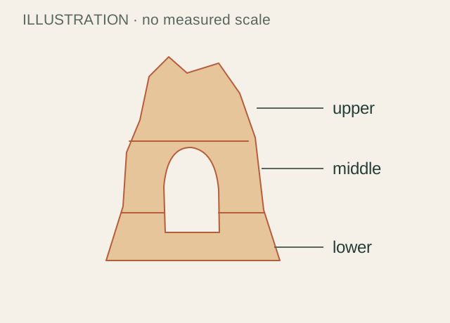
Which two statements can you directly observe in this illustration? Select both.
The drawing shows one opening through the fin.
The drawing has three labeled bands.
The opening in a real Bryce fin is 4 m wide.
Freezing water definitely made this particular opening.
My reasoning:
Assumptions. This original drawing has no scale or field measurements. Its three bands are visual labels, not identified rock formations.
Diagram in words & a hint
An original rock-fin drawing contains one opening and three labeled horizontal bands: upper, middle and lower. No scale bar or measured location is provided.
Hint: Could someone check the claim just by looking at the marks on this page?
Original illustration. Invented geometry, not a surveyed Bryce location.
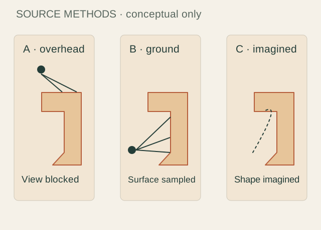
You need measurements of a recess hidden beneath a rock overhang. Which source directly supports that task?
A · An overhead image whose view of the recess is blocked
B · A ground-level scan that samples the recess, with documented scale, coverage and uncertainty
C · An artist’s detailed model of what the recess might look like
My reasoning:
Assumptions. This is a desk exercise about source choice. The scan described in option B is hypothetical; no real scan is supplied in this pack.
Diagram in words & a hint
Three conceptual panels show an overhead view blocked by an overhang, ground-level rays reaching the recess, and an imagined dotted outline. They are illustrations of source methods, not actual images, point clouds or survey results.
Hint: Which source actually records the hidden surface, rather than guessing it?
B fits. On the west, each 10-unit climb takes a longer horizontal distance. On the east, the same climb is squeezed into less space. The labels increase inward, so the center is a hill, not a hollow.
Close contour spacing means a steeper slope when the contour interval and map scale are the same.
02 · One line, one height
A and B have the same elevation.; C is 20 units higher than A.
A and B both lie on the 30-unit contour. C lies on the 50-unit contour, so it is 20 units higher. A contour label gives no horizontal distance between A and B.
A contour connects equal elevations. Its shape is not a ruler.
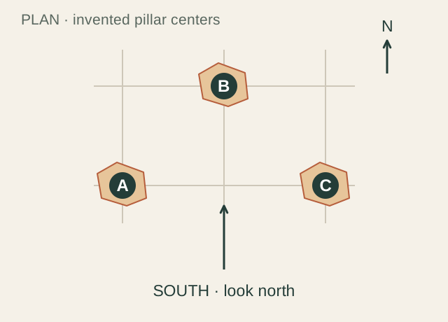
03 · Look north, read left
A → B → C
A → B → C. Facing north puts west on your left and east on your right. A is west of B, and C is east of B. Facing south would reverse the order.
A north arrow describes the map. Left and right belong to the viewer.
04 · Hidden behind a neighbor
A and C
A and C share the same north–south position. Looking due east, A is nearer and C is behind it. B sits farther north, so its center appears to the left of theirs. This does not mean C’s entire silhouette disappears.
One view cannot show every surface. An overlap is not evidence that the hidden object is absent.
Canyon Puzzles · answer key 2 of 3
The reasoning, revealed
05 · Borrow the scale bar
12 m
3 × 4 m = 12 m. The vertical guide and horizontal bar use the same scale. The answer stays 12 m if the whole diagram is enlarged uniformly.
Use the scale relationship, not a ruler on your screen.
06 · Bigger on paper
Both drawings represent an 80 m span.; B’s longer printed scale bar still represents 20 m.
Each ridge spans four of its own 20 m bars: 4 × 20 = 80 m. B’s ridge and bar are both 1.5 times as long on the page. Enlarging existing marks cannot recover detail that was never recorded.
A bar scale survives uniform resizing when it resizes with the drawing.
07 · The oldest goes first
D · pebbly base layer → B · striped layer → A · dashed layer → C · dotted top layer
D → B → A → C. Under the stated conditions, a lower sedimentary layer was deposited before the layer above it. This gives a sequence, not ages in years or the duration of any gaps.
Relative time tells us before and after; it does not supply a date.
08 · The missing middle
B formed on the right, then eroded before C was deposited.; B was never deposited on the right.
Either B was removed before C arrived, or B was not deposited there. The two simplified records cannot decide between those histories or tell us how much time is missing. More evidence is needed.
An incomplete record can support multiple explanations. Keep them open until evidence distinguishes them.
Canyon Puzzles · answer key 3 of 3
The reasoning, revealed
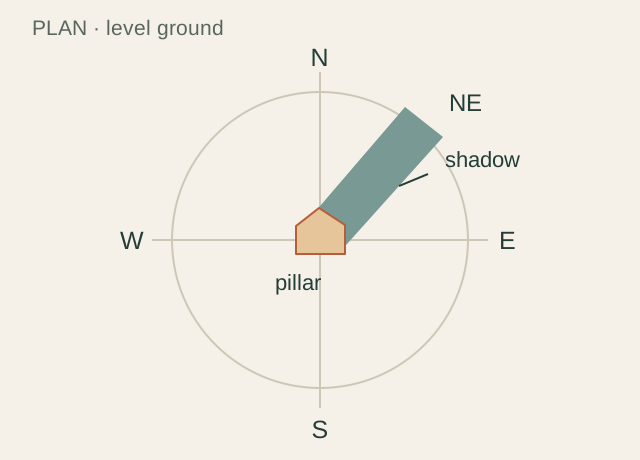
09 · Find the light
Southwest
Southwest. Reverse the northeast shadow direction by half a turn. This answers the drawing’s geometry; it does not establish a time of day at Bryce.
Direction can be inferred from a shadow only within stated lighting and surface assumptions.
10 · A longer reach
A · The lower light at 30°
A, the 30° light. A shallower ray travels farther horizontally before reaching the ground. In this ideal geometry, length = height ÷ tan(angle): about 10.4 units at 30°, versus 3.5 at 60°.
A lower light produces a longer shadow on level ground. Real slopes can change the result.
11 · Look, then interpret
The drawing shows one opening through the fin.; The drawing has three labeled bands.
One opening and three labeled bands are visible. Neither a real-world width nor the cause of a particular opening follows from this drawing. NPS explains frost wedging as a Bryce process, but a general explanation does not turn an invented fin into a field record.
Separate what is shown, what is inferred and what has been measured.
12 · Can this source see it?
B · A ground-level scan that samples the recess, with documented scale, coverage and uncertainty
B. It records the target surface and documents how to interpret its dimensions. A cannot see the recess; C can illustrate a possibility but is not a measurement. Even a real scan needs a coverage and uncertainty check. No substitute model here establishes a ground scan of Thor’s Hammer.
Match the evidence to the question. A beautiful reconstruction cannot fill a measurement gap by appearance alone.