Print the observation deck
24 cards · two per US Letter sheet · 12 sheets. Print at 100%, with browser headers and footers off. Cut between the cards. A4 can use “fit to page”.
Educator answer guide · Text alternatives and mini-lessons · Source key and rights
Use your browser’s Print command. Choose all statements supported by each card, and discuss other defensible observations. The cards contain no answer key on their fronts.
Three silhouettes
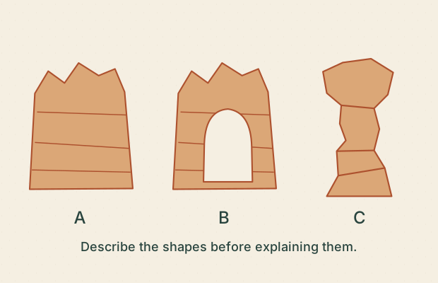
Illustrative · Direct for features of the drawing; illustrative for landforms.
Sources G02, G03 · Lesson 01
Which statements describe visible shapes in this drawing?
Choose every supported statement.
- □ A. B contains an opening.
- □ B. C stands apart as a pillar.
- □ C. A is exactly 100 metres tall.
- □ D. B will collapse next year.
I observe…
I would need to know…
BCC / GEOLOGY OBSERVATIONS02 / 24A wall seen twice
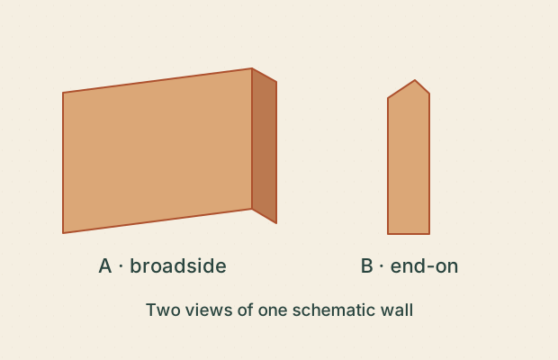
Illustrative · Direct for the labeled drawing; no field identification.
Sources G02 · Lesson 01
The captions identify two views of the same teaching shape. What follows?
Choose every supported statement.
- □ A. A single narrow silhouette can hide a longer wall.
- □ B. The rock changed between views.
- □ C. The end-on view alone proves an isolated hoodoo.
- □ D. A second angle can resolve some shape ambiguity.
I observe…
I would need to know…
BCC / GEOLOGY OBSERVATIONS03 / 24Name versus evidence
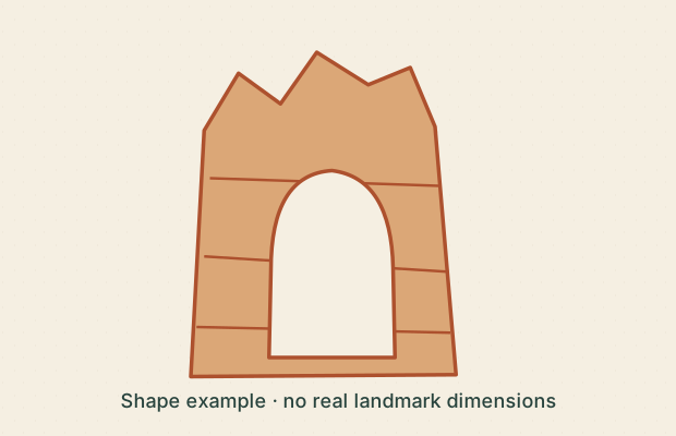
Illustrative · Direct for the sketch; source-supported for the named place.
Sources G03 · Lesson 01
NPS discusses Natural Bridge among Bryce’s arches and windows. Which claims are justified?
Choose every supported statement.
- □ A. The place name proves a river cut the opening.
- □ B. The NPS account is evidence for its geological description.
- □ C. The sketch measures the real opening’s width.
- □ D. The drawing contains rock over an opening.
I observe…
I would need to know…
BCC / GEOLOGY OBSERVATIONS04 / 24Order without thickness
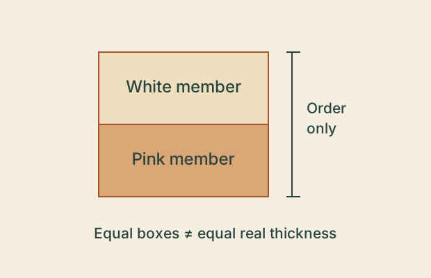
Illustrative · Source-supported order; illustrative geometry.
Sources G04, G07 · Lesson 02
This simplified Claron column shows the informal white member above the pink member. What does it communicate?
Choose every supported statement.
- □ A. The white member is shown above the pink member.
- □ B. Both members have equal real thickness.
- □ C. Every white patch in Bryce is the white member.
- □ D. The illustration omits local variation.
I observe…
I would need to know…
BCC / GEOLOGY OBSERVATIONS05 / 24Color is a clue
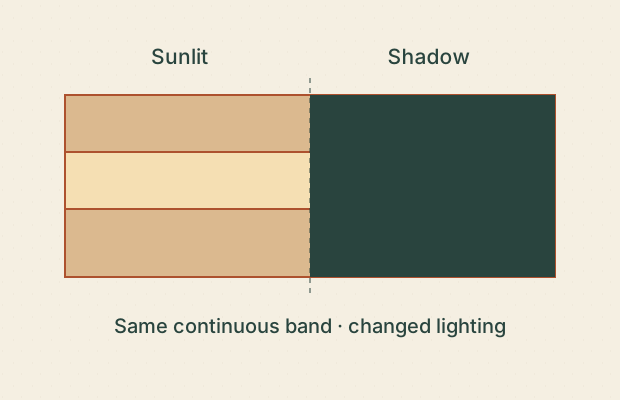
Illustrative · Direct for the drawing; insufficient for material identity.
Sources G07 · Lesson 02
The same schematic band is shown in light and shadow. Which statements stay defensible?
Choose every supported statement.
- □ A. The band is continuous across the drawn shadow.
- □ B. The darker half must be a different formation.
- □ C. A geological unit needs more evidence than this color change.
- □ D. The pale half must be stronger rock.
I observe…
I would need to know…
BCC / GEOLOGY OBSERVATIONS06 / 24Older is not a number
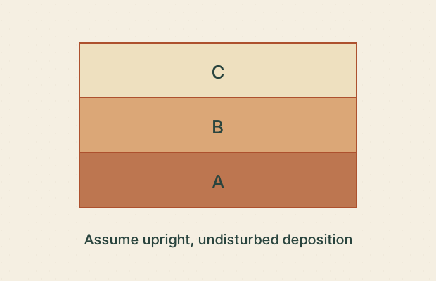
Illustrative · Logical inference from explicit assumptions; no absolute ages.
Sources G05 · Lesson 02
Assume these three sediment layers are upright, undisturbed and deposited in sequence. What follows?
Choose every supported statement.
- □ A. A was deposited before C.
- □ B. B took exactly one million years to form.
- □ C. All three took equally long to form.
- □ D. The conclusion depends on the stated assumptions.
I observe…
I would need to know…
BCC / GEOLOGY OBSERVATIONS07 / 24A crack is not enough
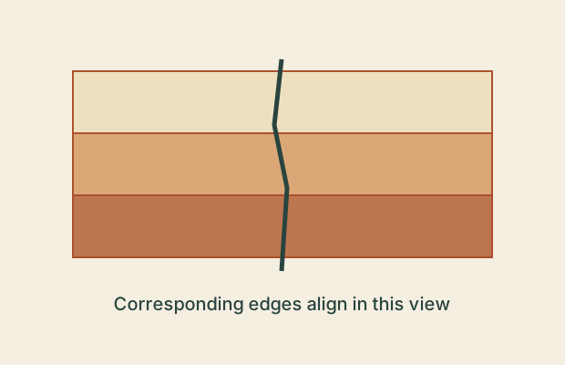
Illustrative · Direct for alignment in this view; movement history unresolved.
Sources G02, G05 · Lesson 03
A line crosses these drawn layers without a visible offset. Which statements are supported?
Choose every supported statement.
- □ A. A crack crosses the layers.
- □ B. No layer offset is shown.
- □ C. An earthquake happened here last week.
- □ D. The line alone proves a fault.
I observe…
I would need to know…
BCC / GEOLOGY OBSERVATIONS08 / 24Where could water go?
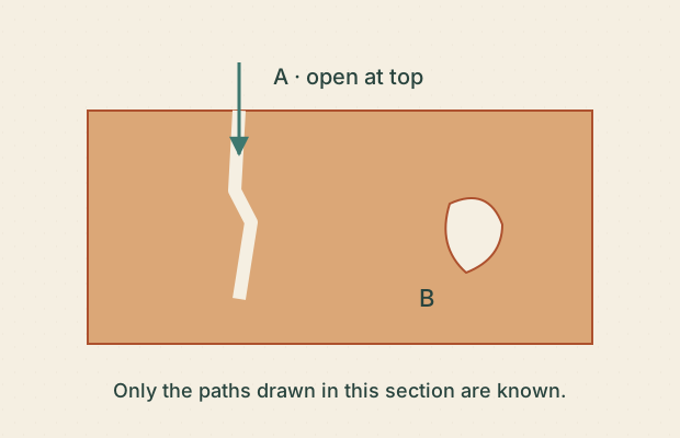
Illustrative · Direct for drawn connectivity; weak for real flow.
Sources G02 · Lesson 03
In this process sketch, which paths are shown as connected to the surface?
Choose every supported statement.
- □ A. A has a drawn route from the surface.
- □ B. B definitely has no connection anywhere in three dimensions.
- □ C. The picture establishes the volume of infiltrating water.
- □ D. B has no surface connection shown in this section.
I observe…
I would need to know…
BCC / GEOLOGY OBSERVATIONS09 / 24A cold night is not a counter
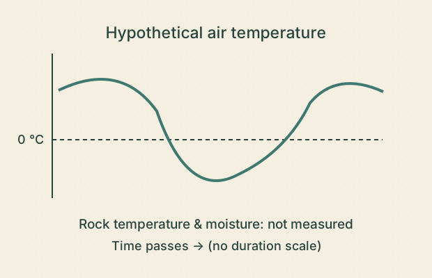
Illustrative · Direct for the hypothetical curve; insufficient for fracture count.
Sources G08 · Lesson 03
The hypothetical record shows air temperature crossing 0 °C, but no rock or moisture measurements. What can you conclude?
Choose every supported statement.
- □ A. The drawn air temperature crosses the freezing reference.
- □ B. Exactly one fracture must have formed.
- □ C. Rock moisture and temperature would improve a process explanation.
- □ D. This is a measured Bryce weather record.
I observe…
I would need to know…
BCC / GEOLOGY OBSERVATIONS10 / 24Break or carry?
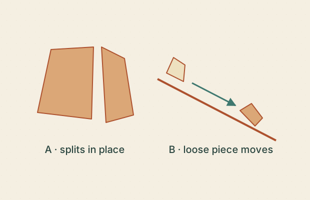
Illustrative · Illustrative mechanism distinction; no field measurement.
Sources G01 · Lesson 04
Two panels isolate different actions. Which descriptions fit?
Choose every supported statement.
- □ A. A illustrates physical breakdown.
- □ B. B illustrates transport of a fragment.
- □ C. A supplies a measured erosion rate.
- □ D. Weathering and transport must always happen separately.
I observe…
I would need to know…
BCC / GEOLOGY OBSERVATIONS11 / 24Material can leave unseen
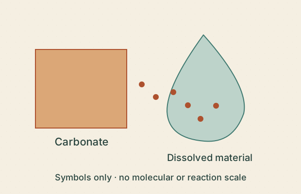
Illustrative · Source-supported process; entirely illustrative symbols.
Sources G05 · Lesson 04
The sketch labels carbonate entering solution in weakly acidic water. Which statements fit the stated process?
Choose every supported statement.
- □ A. Material can leave without becoming a visible loose pebble.
- □ B. All rock dissolves at the same speed.
- □ C. The dots count real molecules.
- □ D. The sketch shows a chemical weathering concept.
I observe…
I would need to know…
BCC / GEOLOGY OBSERVATIONS12 / 24A pile is a clue
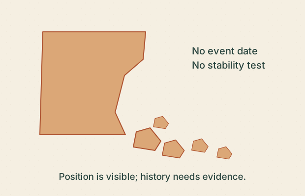
Illustrative · Direct for position; tentative for process and unknown for timing.
Sources G03 · Lesson 04
Loose fragments sit below a drawn cliff. What is a careful reading?
Choose every supported statement.
- □ A. Fragments are drawn below the cliff.
- □ B. They all fell this morning.
- □ C. Gravity is a plausible transport explanation to investigate.
- □ D. The remaining cliff is proven safe.
I observe…
I would need to know…
BCC / GEOLOGY OBSERVATIONS13 / 24Read the drop
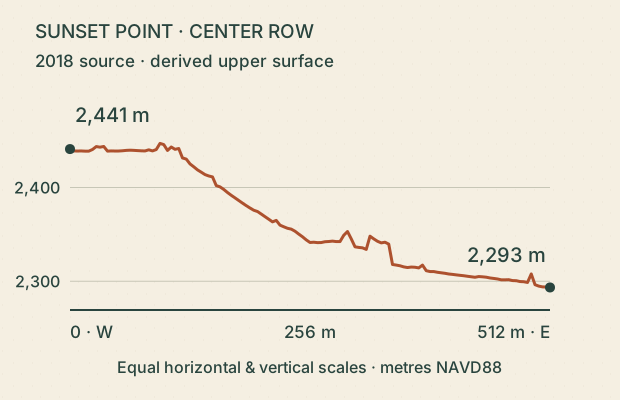
Derived · Derived numerical evidence; source accuracy not established by export precision.
Sources D01, D02 · Lesson 05
Use the labeled endpoints of the derived Sunset profile. Which statements follow?
Choose every supported statement.
- □ A. The west endpoint is higher in this derived profile.
- □ B. The rounded endpoint difference is about 148 m.
- □ C. This is a measured 148 m rockfall.
- □ D. The line is a surveyed walking route.
I observe…
I would need to know…
BCC / GEOLOGY OBSERVATIONS14 / 24Compare equal spans
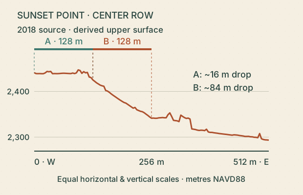
Derived · Derived arithmetic; no route qualification.
Sources D01 · Lesson 05
A and B each span 128 m horizontally. Compare their endpoint drops in the same derived profile.
Choose every supported statement.
- □ A. B has the larger endpoint drop.
- □ B. B has the greater average downward grade between its endpoints.
- □ C. Every small segment within B is steeper than every segment within A.
- □ D. B is therefore safe to descend.
I observe…
I would need to know…
BCC / GEOLOGY OBSERVATIONS15 / 24Below the line
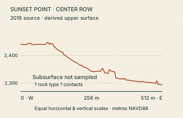
Derived · Derived surface; no subsurface evidence.
Sources D01, G07 · Lesson 05
Only the top line comes from terrain data. What can the empty space beneath it tell us?
Choose every supported statement.
- □ A. The profile identifies underground layer contacts.
- □ B. The blank region communicates missing information.
- □ C. A geological map or measured section could add relevant evidence.
- □ D. The blank region means the ground is hollow.
I observe…
I would need to know…
BCC / GEOLOGY OBSERVATIONS16 / 24One height cannot hold an arch
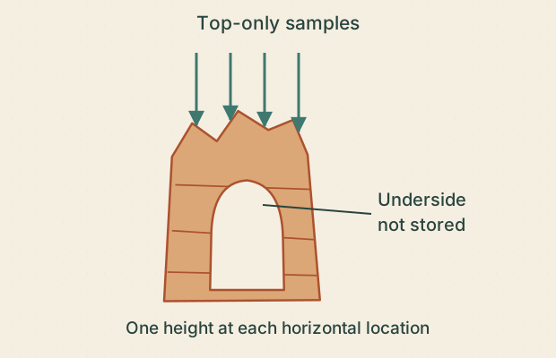
Illustrative · Direct representation limit, supported by the source method.
Sources D01 · Lesson 06
An upper-envelope grid stores only the top height at each horizontal position. Which claim follows?
Choose every supported statement.
- □ A. A top-only grid can fully describe both roof and underside at the same position.
- □ B. A filled model opening proves the real opening is filled.
- □ C. The model’s missing underside is an evidence limitation.
- □ D. Another source is needed to establish hidden geometry.
I observe…
I would need to know…
BCC / GEOLOGY OBSERVATIONS17 / 24Spacing is not accuracy
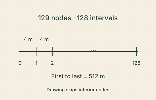
Derived · Derived metadata and arithmetic; accuracy remains separate.
Sources D01 · Lesson 06
The exported profile contains 129 nodes across 512 m. Which statements are justified?
Choose every supported statement.
- □ A. There are 128 intervals between 129 nodes.
- □ B. The sample spacing is 4 m.
- □ C. Every height is accurate to 4 m.
- □ D. Adding interpolated nodes creates new measured detail.
I observe…
I would need to know…
BCC / GEOLOGY OBSERVATIONS18 / 24Two dates, one model
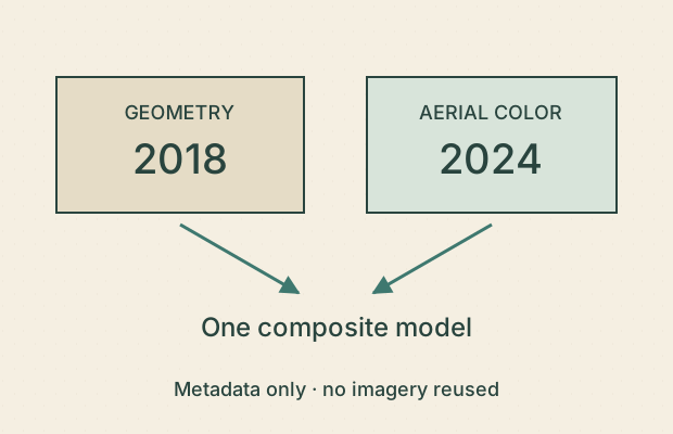
Reference · Direct inherited metadata; no change detection.
Sources D01 · Lesson 06
The integrated Sunset study lists 2018 geometry and 2024 aerial color. Which statements follow?
Choose every supported statement.
- □ A. The inputs were acquired in different years.
- □ B. The combined model is a live view.
- □ C. Every colored detail is a measured three-dimensional surface.
- □ D. The dates should stay with the model’s interpretation.
I observe…
I would need to know…
BCC / GEOLOGY OBSERVATIONS19 / 24Two different ages
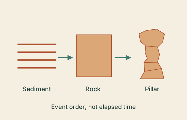
Illustrative · Source-informed relative sequence; no numerical chronology.
Sources G01 · Lesson 07
The diagram separates sediment becoming rock from a pillar becoming isolated. What can it establish?
Choose every supported statement.
- □ A. Rock formation and pillar isolation are different events.
- □ B. The pillar’s current shape is as old as its sediment.
- □ C. The arrows supply exact durations.
- □ D. An age for the rock alone would not date pillar isolation.
I observe…
I would need to know…
BCC / GEOLOGY OBSERVATIONS20 / 24A sequence is not a forecast
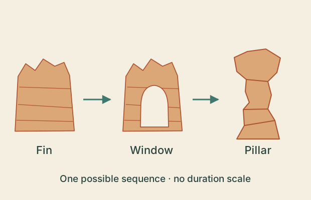
Illustrative · Illustrative process sequence; no forecast.
Sources G03 · Lesson 07
The labeled conceptual panels show a fin, a window and a remaining pillar. Which claims fit?
Choose every supported statement.
- □ A. The panels illustrate a possible progression of forms.
- □ B. Each panel lasts the same number of years.
- □ C. Every hoodoo must pass through exactly these shapes.
- □ D. The last panel predicts a named landmark’s failure date.
I observe…
I would need to know…
BCC / GEOLOGY OBSERVATIONS21 / 24One profile, no rate
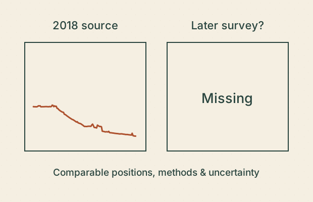
Derived · Derived baseline; insufficient evidence for temporal change.
Sources D01 · Lesson 07
You have one derived terrain profile from the 2018 source. What would support a defensible change estimate?
Choose every supported statement.
- □ A. Divide its relief by the number of years since 2018.
- □ B. Obtain a comparable later survey and align the observations.
- □ C. Account for uncertainty and differences in processing.
- □ D. Assume every difference is erosion.
I observe…
I would need to know…
BCC / GEOLOGY OBSERVATIONS22 / 24A ledge has several stories
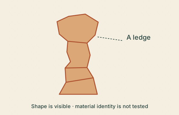
Illustrative · Direct shape observation; tentative process interpretation.
Sources G01, G07 · Lesson 08
A layer juts out farther than its neighbors in this sketch. Which statements keep evidence and explanation separate?
Choose every supported statement.
- □ A. One interval projects outward in the drawing.
- □ B. Contrasting resistance is one possible explanation to test.
- □ C. The sketch proves that interval is dolomite.
- □ D. The ledge will never erode.
I observe…
I would need to know…
BCC / GEOLOGY OBSERVATIONS23 / 24Match the question to the source
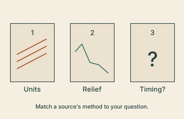
Illustrative · Source-method reasoning; no new geological or stability finding.
Sources G07, D01 · Lesson 08
You want to investigate rock-unit boundaries, surface relief and exact collapse timing. Which matches are defensible?
Choose every supported statement.
- □ A. A geological map or section can inform rock-unit relationships.
- □ B. A derived elevation profile can inform surface relief.
- □ C. A single sketch establishes an exact collapse date.
- □ D. Every source answers every geological question equally well.
I observe…
I would need to know…
BCC / GEOLOGY OBSERVATIONS24 / 24Write the careful caption
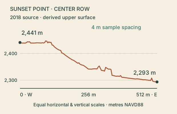
Derived · Derived surface comparison; explicit limits on interpretation.
Sources D01, D02 · Lesson 08
Choose the captions that fit this derived Sunset profile without adding unsupported claims.
Choose every supported statement.
- □ A. ‘A derived 2018-source profile has a higher west endpoint than east endpoint.’
- □ B. ‘The cliff lost 148 m since 2018.’
- □ C. ‘This profile does not resolve buried layers or hidden undersides.’
- □ D. ‘These lines measure the real rock layers.’
I observe…
I would need to know…