THE COMPLETE READING EDITION
Geology observation cards 24 illustrated prompts. Eight linked mini-lessons. Every answer includes its evidence and its limits.
No JavaScript is required. Choose every supported statement before opening the reasoning. Other defensible observations are welcome.
01 · Start with shape 02 · Read the layers 03 · Follow the cracks 04 · Track the material 05 · Read a terrain profile 06 · Question the model 07 · Keep time in perspective 08 · Build a careful explanation LESSON 01 / 08
Start with shape A shape description is an observation; an explanation of how it formed is an interpretation. A fin is a narrow wall, a window is an opening, and a hoodoo is a standing pillar. Those words organize a view without dating it. A single silhouette can hide depth or overlap.
Try a sentence that begins ‘I can see…’ and another that begins ‘One possible explanation is…’. Keep them separate.
Sources: G02 · G03 · Explore the integrated hoodoo guide
CARD 01 · ILLUSTRATIVE
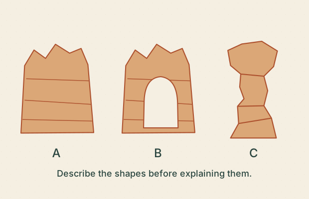
Three silhouettes Direct for features of the drawing; illustrative for landforms.
Which statements describe visible shapes in this drawing?
A. B contains an opening.B. C stands apart as a pillar.C. A is exactly 100 metres tall.D. B will collapse next year.Compare the reasoning A · Supported. The light opening is enclosed by the drawn rock.B · Supported. Its outline is separated from the other rock shapes.C · Not established. There is no scale or measurement.D · Not established. The illustration supplies no stability or timing evidence.Observe. The middle shape has a hole; the right shape is isolated.
Interpret. The sketches illustrate a fin, a window and a hoodoo. They are shape examples, not measured Bryce landmarks.
Another valid observation. ‘There is rock above the opening’ or ‘A is wider than C in the drawing’ are also defensible visible observations.
Limit. No real dimensions, dates or future condition can be read from these silhouettes.
Next question. What would another viewing angle add?
Sources: G02 · G03 · Try card 01 in the studio
CARD 02 · ILLUSTRATIVE
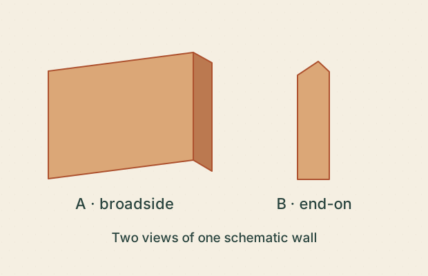
A wall seen twice Direct for the labeled drawing; no field identification.
The captions identify two views of the same teaching shape. What follows?
A. A single narrow silhouette can hide a longer wall.B. The rock changed between views.C. The end-on view alone proves an isolated hoodoo.D. A second angle can resolve some shape ambiguity.Compare the reasoning A · Supported. The second view conceals the dimension visible in the first.B · Not established. Only the viewpoint is changed in the stated example.C · Not established. A thin wall can look like a pillar from its end.D · Supported. The broadside view exposes the wall’s length.Observe. One view shows length; the other mainly shows thickness.
Interpret. Apparent outline depends on viewpoint. Multiple views can test whether a narrow outline belongs to a pillar or a wall.
Another valid observation. ‘View B hides one dimension’ is a useful alternative; no numerical length is required.
Limit. This is an original perspective exercise, not two photographs of a named landform.
Next question. Which extra view would help you distinguish a fin from a pillar?
Sources: G02 · Try card 02 in the studio
CARD 03 · ILLUSTRATIVE
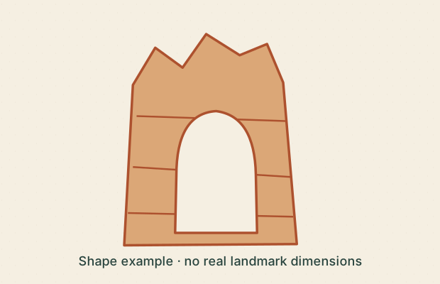
Name versus evidence Direct for the sketch; source-supported for the named place.
NPS discusses Natural Bridge among Bryce’s arches and windows. Which claims are justified?
A. The place name proves a river cut the opening.B. The NPS account is evidence for its geological description.C. The sketch measures the real opening’s width.D. The drawing contains rock over an opening.Compare the reasoning A · Not established. Names do not establish a formation mechanism.B · Supported. This is a source-based interpretation, not a conclusion from the sketch alone.C · Not established. It is explicitly an unscaled shape example.D · Supported. That is a direct visible observation.Observe. Rock spans an opening in the drawing.
Interpret. NPS treats the named Natural Bridge as an arch/window and notes that process terminology can be imprecise.
Another valid observation. You may call the drawn feature an opening or window without claiming its origin.
Limit. Neither the drawing nor the name supplies a process history or dimensions for the real feature.
Next question. Which part of your answer came from looking, and which from reading?
Sources: G03 · Try card 03 in the studio
LESSON 02 / 08
Read the layers The Claron Formation includes informal lower pink and upper white members. These names do not turn every pink or white patch into a mapped unit. Geologists compare material, bedding and geographic relationships. In an upright, undisturbed sedimentary sequence, a lower deposited layer precedes the layer above it; a drawing of that order supplies no duration.
Name the visible pattern first. Ask what a geological map or measured section would add.
Sources: G04 · G05 · G07 · Explore the integrated rock-layer exhibit
CARD 04 · ILLUSTRATIVE
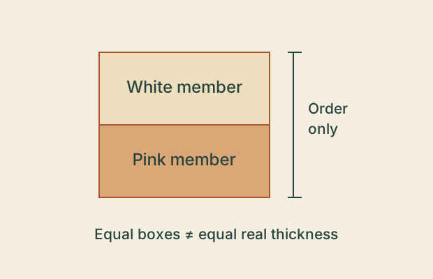
Order without thickness Source-supported order; illustrative geometry.
This simplified Claron column shows the informal white member above the pink member. What does it communicate?
A. The white member is shown above the pink member.B. Both members have equal real thickness.C. Every white patch in Bryce is the white member.D. The illustration omits local variation.Compare the reasoning A · Supported. The labels and their vertical order support this.B · Not established. Equal boxes are a layout choice; there is no thickness scale.C · Not established. A color patch alone does not establish a mapped unit.D · Supported. It is an explicitly simplified column, not a local measured section.Observe. The white-member label sits above the pink-member label.
Interpret. This summarizes the informal member order in the NPS wayside, not a complete section at every location.
Another valid observation. ‘No scale is given’ is a valid evidence observation.
Limit. Do not infer equal thickness, universal preservation or a contact from color alone.
Next question. What could a measured section add that these boxes cannot?
Sources: G04 · G07 · Try card 04 in the studio
CARD 05 · ILLUSTRATIVE
Color is a clue Direct for the drawing; insufficient for material identity.
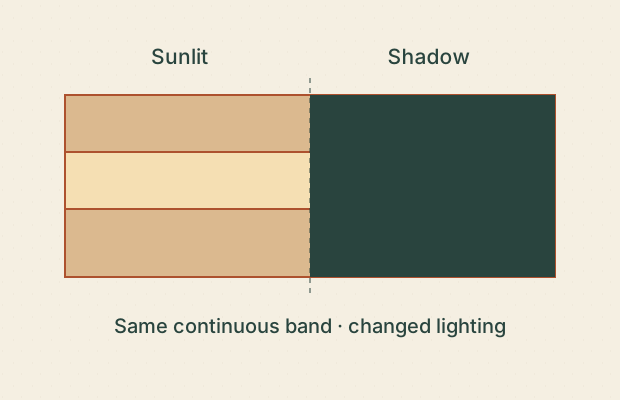
The same schematic band is shown in light and shadow. Which statements stay defensible?
A. The band is continuous across the drawn shadow.B. The darker half must be a different formation.C. A geological unit needs more evidence than this color change.D. The pale half must be stronger rock.Compare the reasoning A · Supported. Its boundaries continue through both lighting conditions.B · Not established. Lighting alone changes the displayed color here.C · Supported. Material and bedding relationships would be relevant.D · Not established. Brightness does not measure strength.Observe. A continuous band looks darker under the drawn shadow.
Interpret. Lighting and material are different explanations for color differences. Unit identification uses more than color.
Another valid observation. ‘The edge does not shift where the shading changes’ is a useful alternative observation.
Limit. The diagram is not a mineral analysis or a mapped Claron exposure.
Next question. What would you record besides color?
Sources: G07 · Try card 05 in the studio
CARD 06 · ILLUSTRATIVE
Older is not a number Logical inference from explicit assumptions; no absolute ages.
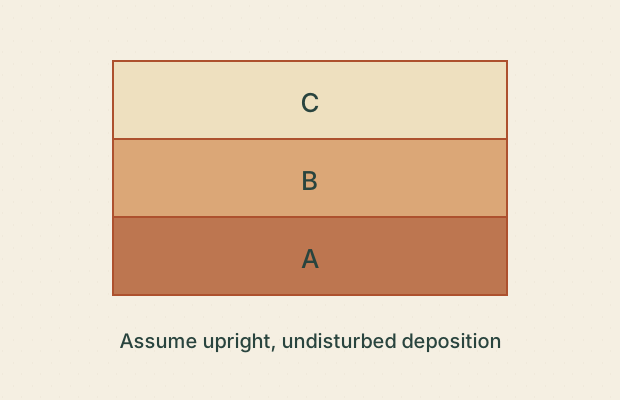
Assume these three sediment layers are upright, undisturbed and deposited in sequence. What follows?
A. A was deposited before C.B. B took exactly one million years to form.C. All three took equally long to form.D. The conclusion depends on the stated assumptions.Compare the reasoning A · Supported. Under the stated assumptions, the lower layer came first.B · Not established. No numerical time information is provided.C · Not established. Drawn thickness does not establish duration.D · Supported. Overturning or disturbance would require a different analysis.Observe. A lies below B, and B below C.
Interpret. Superposition gives relative order under the stated conditions. It does not assign numerical ages.
Another valid observation. ‘C was deposited after B’ is equally valid under the same assumptions.
Limit. An original generic section, not a dated Bryce stratigraphic column.
Next question. What evidence might help place a numerical age on a layer?
Sources: G05 · Try card 06 in the studio
LESSON 03 / 08
Follow the cracks Cracks help water reach rock interiors. NPS describes joints as boundaries along which fins and narrow passages develop. A fault requires movement along a fracture; a line in an image alone does not establish that movement. Freezing conditions and water can contribute to rock damage, but a thermometer crossing zero is not a count of broken rocks.
Describe the crack, then list one observation you would need to test a process explanation.
Sources: G02 · G05 · G08 · Explore the integrated weathering lab
CARD 07 · ILLUSTRATIVE
A crack is not enough Direct for alignment in this view; movement history unresolved.
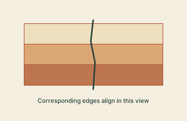
A line crosses these drawn layers without a visible offset. Which statements are supported?
A. A crack crosses the layers.B. No layer offset is shown.C. An earthquake happened here last week.D. The line alone proves a fault.Compare the reasoning A · Supported. The line intersects all three bands.B · Supported. Corresponding band boundaries align in this view.C · Not established. No event date or field evidence is supplied.D · Not established. A fault requires movement; the crack alone does not demonstrate it.Observe. The band edges align on either side of the crack.
Interpret. The drawing is consistent with a fracture without shown displacement. Absence of visible offset in one view does not prove no movement ever occurred.
Another valid observation. ‘We need another view or a displaced marker to test movement’ is defensible.
Limit. No real fracture is mapped or dated; out-of-plane movement is not resolved.
Next question. What would make a fault interpretation stronger?
Sources: G02 · G05 · Try card 07 in the studio
CARD 08 · ILLUSTRATIVE
Where could water go? Direct for drawn connectivity; weak for real flow.
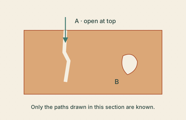
In this process sketch, which paths are shown as connected to the surface?
A. A has a drawn route from the surface.B. B definitely has no connection anywhere in three dimensions.C. The picture establishes the volume of infiltrating water.D. B has no surface connection shown in this section.Compare the reasoning A · Supported. The opening and arrows join the surface to A.B · Not established. The drawing cannot exclude a connection outside this section.C · Not established. No flow measurement or calibrated arrow scale exists.D · Supported. That carefully limits the claim to what is visible.Observe. Only crack A is visibly connected to the top of this section.
Interpret. Connected cracks can provide access for water. A two-dimensional drawing cannot settle all three-dimensional pathways.
Another valid observation. ‘Water access to B is unknown’ is valid; ‘B is always dry’ is not established.
Limit. Arrows show an illustrative possibility, not measured infiltration or a real cave system.
Next question. How would you express the unknown without filling it in?
Sources: G02 · Try card 08 in the studio
CARD 09 · ILLUSTRATIVE
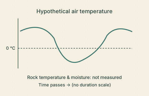
A cold night is not a counter Direct for the hypothetical curve; insufficient for fracture count.
The hypothetical record shows air temperature crossing 0 °C, but no rock or moisture measurements. What can you conclude?
A. The drawn air temperature crosses the freezing reference.B. Exactly one fracture must have formed.C. Rock moisture and temperature would improve a process explanation.D. This is a measured Bryce weather record.Compare the reasoning A · Supported. The curve crosses the 0 °C line.B · Not established. A crossing is not a measurement of rock damage.C · Supported. Those address missing conditions relevant to freezing damage.D · Not established. The record is labeled hypothetical.Observe. The curve passes below and above the reference line.
Interpret. Water availability and rock thermal conditions matter. Experimental frost-fracture research also includes ice segregation, beyond a simple event counter.
Another valid observation. ‘There is no observed crack change’ is a valid evidence-limit statement.
Limit. No climate series, damage count or erosion rate is supplied.
Next question. What would you measure to test whether the rock actually changed?
Sources: G08 · Try card 09 in the studio
LESSON 04 / 08
Track the material Weathering changes or breaks rock; erosion carries material away. Slightly acidic water can dissolve carbonate material, while gravity and runoff can move fragments. These processes can work together. A diagram can isolate one step for discussion without representing a complete physical experiment.
Follow one marked piece. Has it changed, moved, or both? Say which evidence supports your choice.
Sources: G01 · G02 · G03 · G05 · Compare processes in the weathering lab
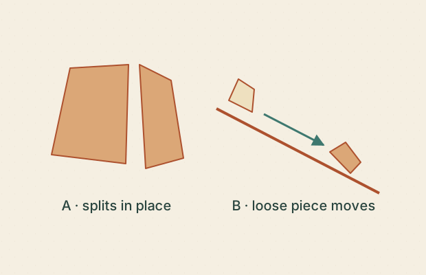
CARD 10 · ILLUSTRATIVE
Break or carry? Illustrative mechanism distinction; no field measurement.
Two panels isolate different actions. Which descriptions fit?
A. A illustrates physical breakdown.B. B illustrates transport of a fragment.C. A supplies a measured erosion rate.D. Weathering and transport must always happen separately.Compare the reasoning A · Supported. The rock separates into pieces without shown transport.B · Supported. Its marked starting and ending positions differ.C · Not established. There are no real times or measured distances.D · Not established. The panels separate concepts for teaching; processes may interact.Observe. A piece divides in A; a loose piece changes position in B.
Interpret. The panels distinguish physical weathering from material transport.
Another valid observation. ‘Both could happen in the same landscape’ is a useful process interpretation, not a pictured event history.
Limit. Drawn arrows do not encode force, distance or elapsed time.
Next question. Could a single rain event involve both kinds of action?
Sources: G01 · Try card 10 in the studio
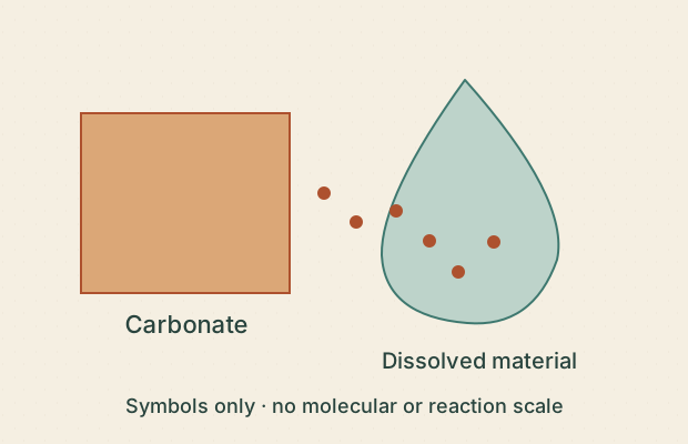
CARD 11 · ILLUSTRATIVE
Material can leave unseen Source-supported process; entirely illustrative symbols.
The sketch labels carbonate entering solution in weakly acidic water. Which statements fit the stated process?
A. Material can leave without becoming a visible loose pebble.B. All rock dissolves at the same speed.C. The dots count real molecules.D. The sketch shows a chemical weathering concept.Compare the reasoning A · Supported. Dissolved material is a different outcome from a transported fragment.B · Not established. The drawing specifies neither all materials nor reaction rates.C · Not established. They are explanatory symbols.D · Supported. The stated process is dissolution, not merely movement of a solid piece.Observe. The labels distinguish a solid block from dissolved material.
Interpret. Carbonate dissolution can remove material without a visible pebble leaving the rock.
Another valid observation. ‘This needs a chemical explanation, not just a shape description’ is defensible.
Limit. No pH, concentration, reaction speed or measured chemistry is represented.
Next question. Why might a before-and-after photograph miss some material loss?
Sources: G05 · Try card 11 in the studio
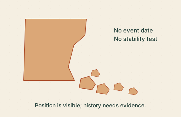
CARD 12 · ILLUSTRATIVE
A pile is a clue Direct for position; tentative for process and unknown for timing.
Loose fragments sit below a drawn cliff. What is a careful reading?
A. Fragments are drawn below the cliff.B. They all fell this morning.C. Gravity is a plausible transport explanation to investigate.D. The remaining cliff is proven safe.Compare the reasoning A · Supported. This describes their visible position.B · Not established. No time evidence is present.C · Supported. It is a process hypothesis compatible with the arrangement.D · Not established. A static pile does not establish stability.Observe. Loose pieces are lower than the drawn cliff face.
Interpret. Gravity is one plausible contributor; the arrangement alone does not identify each fragment’s source or travel history.
Another valid observation. ‘The pieces could have accumulated in multiple events’ is possible but not demonstrated.
Limit. This is not a rockfall forecast or an access recommendation.
Next question. What information would separate one event from many?
Sources: G03 · Try card 12 in the studio
LESSON 05 / 08
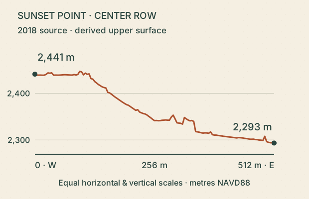
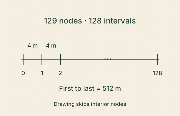
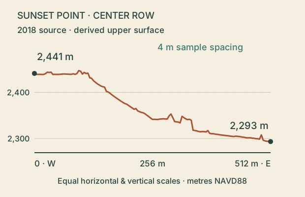
Read a terrain profile These cards use the center east–west row of the integrated Sunset Point terrain study. Its 129 samples span 512 metres, so adjacent samples are 4 metres apart. Heights are derived from 2018 airborne lidar, filtered and gridded by the earlier study. The profile shows a top surface, not underground layers, a walking route or a current safety assessment.
Read both axes. Separate a calculation on the exported data from a new field measurement.
Sources: D01 · D02 · Open the integrated Sunset Point study
CARD 13 · DERIVED
Read the drop Derived numerical evidence; source accuracy not established by export precision.
Use the labeled endpoints of the derived Sunset profile. Which statements follow?
A. The west endpoint is higher in this derived profile.B. The rounded endpoint difference is about 148 m.C. This is a measured 148 m rockfall.D. The line is a surveyed walking route.Compare the reasoning A · Supported. 2,441 m exceeds 2,293 m.B · Supported. 2,441 minus 2,293 equals 148; the retained unrounded difference is 147.62 m.C · Not established. These are two places in one dataset, not the same place before and after.D · Not established. It is an east–west row through an upper-envelope terrain model.Observe. The west endpoint is visibly and numerically higher.
Interpret. The difference is a calculation on an existing data derivative, not a new field measurement or change detection.
Another valid observation. ‘The east end is about 148 m lower’ is equivalent; ‘the whole line is downhill’ is not true of every segment.
Limit. 2018 source, 4 m exported spacing; an upper surface with filtering/interpolation limits.
Next question. Why is an elevation difference different from an erosion measurement?
Sources: D01 · D02 · Try card 13 in the studio
CARD 14 · DERIVED
Compare equal spans Derived arithmetic; no route qualification.
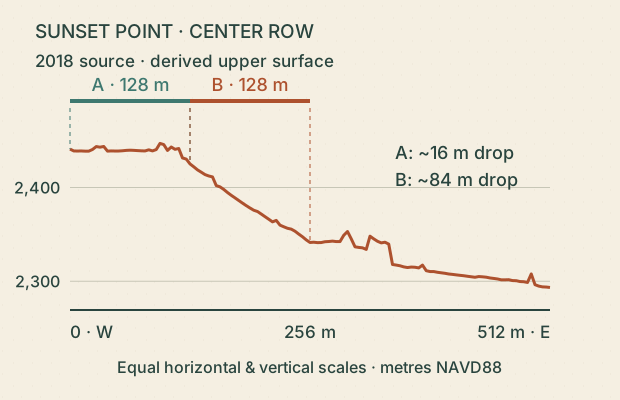
A and B each span 128 m horizontally. Compare their endpoint drops in the same derived profile.
A. B has the larger endpoint drop.B. B has the greater average downward grade between its endpoints.C. Every small segment within B is steeper than every segment within A.D. B is therefore safe to descend.Compare the reasoning A · Supported. B drops about 84 m; A drops about 16 m.B · Supported. With equal horizontal distances, the larger drop gives the larger mean grade magnitude.C · Not established. Endpoint comparisons do not describe every local segment.D · Not established. A profile comparison is not a route or safety assessment.Observe. Equal horizontal spans contain unequal endpoint drops.
Interpret. The derived endpoint grades are about 12.4% downward for A and 65.5% for B. These are profile calculations, not measured trail grades.
Another valid observation. ‘B drops roughly five times as much over the same horizontal span’ is an acceptable approximate comparison.
Limit. Local slope, accessible tread and stability cannot be inferred from this two-endpoint comparison.
Next question. What changes if the spans have different horizontal lengths?
Sources: D01 · Try card 14 in the studio
CARD 15 · DERIVED
Below the line Derived surface; no subsurface evidence.
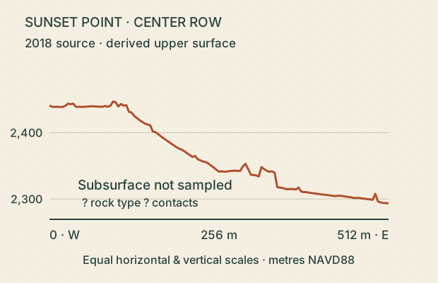
Only the top line comes from terrain data. What can the empty space beneath it tell us?
A. The profile identifies underground layer contacts.B. The blank region communicates missing information.C. A geological map or measured section could add relevant evidence.D. The blank region means the ground is hollow.Compare the reasoning A · Not established. The dataset supplies surface heights, not buried contacts.B · Supported. It is deliberately left uninterpreted.C · Supported. Those sources can address material and stratigraphic relationships.D · Not established. An absence of drawn data is not a physical void.Observe. A surface line is present; subsurface boundaries are not.
Interpret. Topography and stratigraphy answer different questions. The section does not justify invented underground bands.
Another valid observation. ‘No rock type is identified by the surface height alone’ is valid.
Limit. The area beneath the profile is unknown in this representation, not an inferred cavity.
Next question. What source would you seek before drawing a contact?
Sources: D01 · G07 · Try card 15 in the studio
LESSON 06 / 08
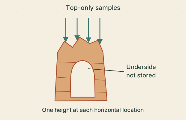
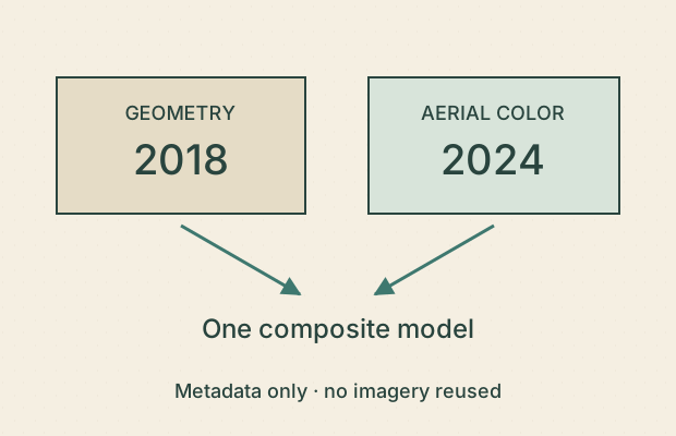
Question the model The Sunset study stores one surface height at each horizontal grid point. That representation cannot describe an overhang’s top and underside at the same location. More samples can improve representation without proving accuracy. Geometry and aerial color can also come from different years. A model is evidence with a method and limits, not a view of everything.
Before using a model, find its source, date, spacing, processing choices and missing surfaces.
Sources: D01 · D02 · Read the integrated terrain methods
CARD 16 · ILLUSTRATIVE
One height cannot hold an arch Direct representation limit, supported by the source method.
An upper-envelope grid stores only the top height at each horizontal position. Which claim follows?
A. A top-only grid can fully describe both roof and underside at the same position.B. A filled model opening proves the real opening is filled.C. The model’s missing underside is an evidence limitation.D. Another source is needed to establish hidden geometry.Compare the reasoning A · Not established. That requires more than one surface height at that horizontal location.B · Not established. The representation may be unable to preserve the opening.C · Supported. The representation and observation geometry limit what is recoverable.D · Supported. Multi-angle evidence could address surfaces unavailable in the top-only grid.Observe. The schematic grid retains the top sample and omits the underside.
Interpret. The integrated study’s upper-envelope method cannot recover a complete arch or ground-level scan.
Another valid observation. ‘More triangles alone cannot provide an unseen underside’ is a valid inference.
Limit. Generic diagram only; no replacement model of Thor’s Hammer or Natural Bridge is made.
Next question. What evidence would you request before filling a hidden surface?
Sources: D01 · Try card 16 in the studio
CARD 17 · DERIVED
Spacing is not accuracy Derived metadata and arithmetic; accuracy remains separate.
The exported profile contains 129 nodes across 512 m. Which statements are justified?
A. There are 128 intervals between 129 nodes.B. The sample spacing is 4 m.C. Every height is accurate to 4 m.D. Adding interpolated nodes creates new measured detail.Compare the reasoning A · Supported. Intervals lie between neighboring nodes, so there is one fewer interval than nodes.B · Supported. 512 divided by 128 equals 4.C · Not established. Sampling distance does not establish elevation accuracy.D · Not established. Interpolation adds estimates between existing samples.Observe. The endpoints enclose 128 equal intervals.
Interpret. Spacing describes the exported representation. Centimetre encoding and a dense grid do not certify source accuracy.
Another valid observation. ‘129 is a node count, not an interval count’ is a useful distinction.
Limit. The number line depicts exported sample geometry, not individual laser footprints.
Next question. Which metadata would you read to learn about actual accuracy?
Sources: D01 · Try card 17 in the studio
CARD 18 · REFERENCE
Two dates, one model Direct inherited metadata; no change detection.
The integrated Sunset study lists 2018 geometry and 2024 aerial color. Which statements follow?
A. The inputs were acquired in different years.B. The combined model is a live view.C. Every colored detail is a measured three-dimensional surface.D. The dates should stay with the model’s interpretation.Compare the reasoning A · Supported. 2018 and 2024 are distinct acquisition dates.B · Not established. Both sources are dated records.C · Not established. Image color and geometry are different inputs.D · Supported. They help users assess temporal mismatch and limits.Observe. The two source records have different dates and roles.
Interpret. A composite can combine evidence from different times. It does not establish what changed between those times.
Another valid observation. ‘The geometry is older than the color imagery’ is defensible; an exact six-year interval is not established by year labels alone.
Limit. Metadata exercise; no aerial photograph is copied and no present condition is claimed.
Next question. Why should a model keep separate geometry and imagery dates?
Sources: D01 · Try card 18 in the studio
LESSON 07 / 08
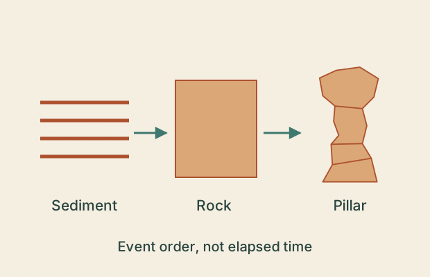
Keep time in perspective Sediment deposition, rock formation and the shaping of an isolated pillar are different events. A conceptual fin–window–pillar sequence does not give their dates or require every pillar to follow one path. The Grand Staircase is a regional rock succession across several landscapes; it is not a set of equal time steps. Detecting change requires comparable observations and uncertainty estimates.
Replace an unsupported date with a question about what could establish it.
Sources: G01 · G03 · G06 · Explore Deep Time at Bryce
CARD 19 · ILLUSTRATIVE
Two different ages Source-informed relative sequence; no numerical chronology.
The diagram separates sediment becoming rock from a pillar becoming isolated. What can it establish?
A. Rock formation and pillar isolation are different events.B. The pillar’s current shape is as old as its sediment.C. The arrows supply exact durations.D. An age for the rock alone would not date pillar isolation.Compare the reasoning A · Supported. The conceptual sequence separates them.B · Not established. Sediment history and later shaping are different questions.C · Not established. They show order only.D · Supported. A second event needs its own dating evidence.Observe. The material exists before the isolated shape in the drawing.
Interpret. The age of a rock is not automatically the age of the landform made from it.
Another valid observation. ‘The shape developed after the material in this model’ is acceptable without adding a date.
Limit. This is a teaching sequence, not a dated reconstruction of one Bryce hoodoo.
Next question. Which event does the phrase ‘How old is it?’ actually refer to?
Sources: G01 · Try card 19 in the studio
CARD 20 · ILLUSTRATIVE
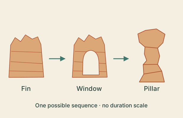
A sequence is not a forecast Illustrative process sequence; no forecast.
The labeled conceptual panels show a fin, a window and a remaining pillar. Which claims fit?
A. The panels illustrate a possible progression of forms.B. Each panel lasts the same number of years.C. Every hoodoo must pass through exactly these shapes.D. The last panel predicts a named landmark’s failure date.Compare the reasoning A · Supported. That is the explicitly stated role of the diagram.B · Not established. Equal panel sizes do not encode equal durations.C · Not established. The simplified sequence is not universal.D · Not established. No named landmark or timing evidence is present.Observe. The opening appears in the middle panel; the final shape is separate.
Interpret. The NPS description supports this broad process story, while the original panels omit alternate histories and timing.
Another valid observation. ‘A connection is lost between the second and third sketch’ describes a visible diagram change.
Limit. No duration, inevitability or collapse prediction is supplied.
Next question. How would you label this figure to avoid implying a countdown?
Sources: G03 · Try card 20 in the studio
CARD 21 · DERIVED
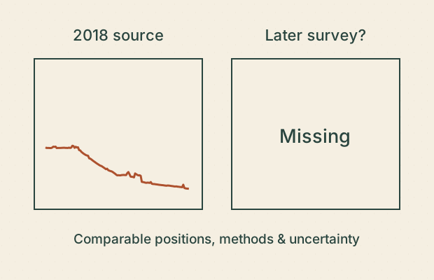
One profile, no rate Derived baseline; insufficient evidence for temporal change.
You have one derived terrain profile from the 2018 source. What would support a defensible change estimate?
A. Divide its relief by the number of years since 2018.B. Obtain a comparable later survey and align the observations.C. Account for uncertainty and differences in processing.D. Assume every difference is erosion.Compare the reasoning A · Not established. Spatial relief is not a measured change over time.B · Supported. A change estimate needs comparable positions and acquisition records.C · Supported. Apparent changes may arise from measurement or method differences.D · Not established. Registration, vegetation and other differences need evaluation.Observe. Only one dated surface is available on the card.
Interpret. A single snapshot cannot provide an erosion rate. A comparison would still need uncertainty analysis and process interpretation.
Another valid observation. ‘No change rate can be calculated from this card’ is a complete valid conclusion.
Limit. No second survey, erosion value or new acquisition is supplied.
Next question. What would make two surveys meaningfully comparable?
Sources: D01 · Try card 21 in the studio
LESSON 08 / 08
Build a careful explanation A strong explanation keeps its evidence visible. An outward ledge might fit contrasting resistance, but a picture does not measure hardness or mineral content. Compare independent sources and competing interpretations. An unanswered question is a useful result when the available evidence cannot decide it.
Use this structure: ‘I observe ___. This could fit ___. To test it, I would need ___.’ Accept more than one defensible observation.
Sources: G01 · G07 · D01 · Continue with the integrated field guide
CARD 22 · ILLUSTRATIVE
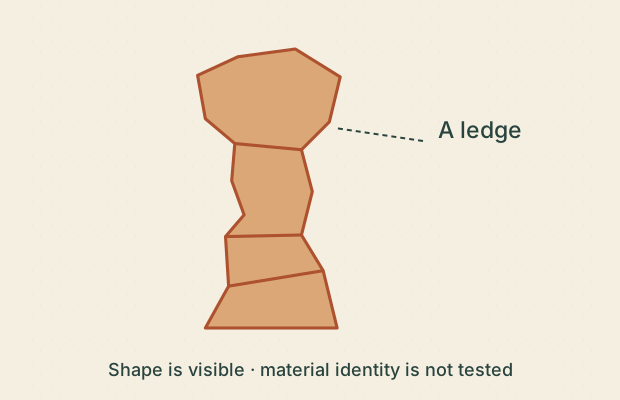
A ledge has several stories Direct shape observation; tentative process interpretation.
A layer juts out farther than its neighbors in this sketch. Which statements keep evidence and explanation separate?
A. One interval projects outward in the drawing.B. Contrasting resistance is one possible explanation to test.C. The sketch proves that interval is dolomite.D. The ledge will never erode.Compare the reasoning A · Supported. This describes the visible shape.B · Supported. It is compatible with differential weathering, without identifying the exact material.C · Not established. Mineral identity requires evidence beyond outline.D · Not established. Relative resistance is not immunity or a forecast.Observe. A wide ledge separates narrower parts of the outline.
Interpret. Differing resistance can contribute to ledges and recesses; the drawing does not identify a rock type or cause uniquely.
Another valid observation. ‘The change could also reflect fracture geometry’ is a reasonable alternative hypothesis, not a confirmed finding.
Limit. Illustrative shape, no sampled bed or strength measurement.
Next question. What would help distinguish material differences from fracture effects?
Sources: G01 · G07 · Try card 22 in the studio
CARD 23 · ILLUSTRATIVE
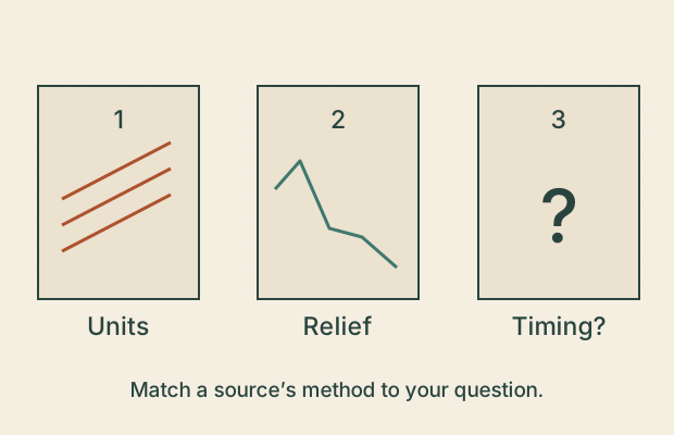
Match the question to the source Source-method reasoning; no new geological or stability finding.
You want to investigate rock-unit boundaries, surface relief and exact collapse timing. Which matches are defensible?
A. A geological map or section can inform rock-unit relationships.B. A derived elevation profile can inform surface relief.C. A single sketch establishes an exact collapse date.D. Every source answers every geological question equally well.Compare the reasoning A · Supported. It addresses geological identification and spatial relationships, within its scale and limits.B · Supported. Its numerical surface heights address that question.C · Not established. The sketch has no predictive physical or temporal evidence.D · Not established. A source’s method and scope constrain the questions it can address.Observe. The source cards contain different types of information.
Interpret. Choose evidence that addresses the question. A precise-looking graphic does not automatically supply the missing information.
Another valid observation. ‘None of these sources alone establishes exact collapse timing’ is a valid conclusion.
Limit. A geological map also has scale and uncertainty limits; it is not a guarantee of any specific contact at any zoom level.
Next question. Which source would you choose for a question about a hidden underside?
Sources: G07 · D01 · Try card 23 in the studio
CARD 24 · DERIVED
Write the careful caption Derived surface comparison; explicit limits on interpretation.
Choose the captions that fit this derived Sunset profile without adding unsupported claims.
A. ‘A derived 2018-source profile has a higher west endpoint than east endpoint.’B. ‘The cliff lost 148 m since 2018.’C. ‘This profile does not resolve buried layers or hidden undersides.’D. ‘These lines measure the real rock layers.’Compare the reasoning A · Supported. It preserves source class, date scope and the visible comparison.B · Not established. It turns spatial relief into an unmeasured time change.C · Supported. It states an actual method limit.D · Not established. The figure shows topography rather than stratigraphy.Observe. A west-to-east surface line is paired with a dated source and sampling note.
Interpret. A careful caption combines the observation, evidence class and an honest limit. Several wordings can do this well.
Another valid observation. ‘The east endpoint is lower in this model; this is not a current survey’ is also defensible.
Limit. Your own wording is not automatically graded; discuss whether each clause is supported.
Next question. Write a different caption that includes one observation and one limit.
Sources: D01 · D02 · Try card 24 in the studio