
Geology laboratory · Experiment 01
What makes a rock
become a hoodoo?
Start with the same imagined wall. Change the water, the fractures, or the rock’s resistance. Compare what each assumption does to the shape.
A teaching experiment, not a forecast. The rock is invented. Steps have no duration in years. These rules cannot predict Bryce’s erosion rate or a landmark’s collapse.
The illustrated guide below works without JavaScript. Interactive controls appear here when the experiment is ready.
Go to the illustrated guideOne starting wall. Two experiments.
Illustrative geometryFront view of a thin fin
Water + frost
Water, without frost
*When resistance contrast is zero, all bands behave alike. Color still marks their positions.
A question to carry into the scene
Does switching off frost switch off all change?
Processes & drawing
Changing a setting reruns B from its starting wall to the selected step. A keeps its reference settings.
The reading trail
Break it.
Move it.
Notice what stays.
The same ideas, without a running model. Use this guide on its own or print it.
Weathering and erosion work together
A crack makes a useful place to begin. Water can enter weaknesses; frost action can help fracture rock, and weakly acidic water can dissolve carbonate minerals or cement. Runoff carries fragments away. Gravity moves material too. These overlapping processes expose more surfaces to change. NPS: fins and runoff · USGS: dissolution.
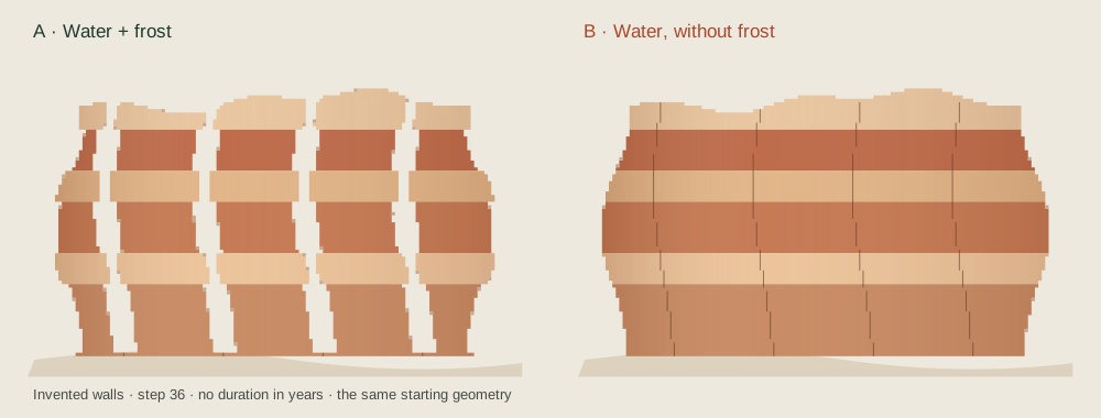
 Illustration The same seeded wall and step count, with one process changed. This illustration is generated by the experiment’s rules; it is not evidence of a real erosion rate.
Find the weakness
A joint is a fracture in the rock. Widened fractures can separate a narrow rock wall, or fin. Openings through a fin are called windows. Isolated irregular columns are hoodoos. This sequence is a useful way to read a landscape, not a required biography for every rock. NPS: windows and fins.
Find the difference
Some bands resist change more than their neighbors. The resulting ledges and recesses help give hoodoos their varied profiles. The experiment assigns resistance directly; in the field, geologists investigate texture, composition, cement and structure. A color alone cannot give you a strength measurement. NPS: material differences.
Five comparisons to try
| Change in B | Look for | What that teaches |
|---|---|---|
| No water | The wall stays intact. | Both weathering rules need water. Other dry-weather processes are absent from this experiment. |
| No frost | Solution still changes the exposed rock. | Removing one process does not remove all weathering. |
| Equal resistance | Colored bands no longer behave differently. | Different shapes need differences in material or exposure; color is just a label here. |
| Hold loose material | Dotted cells accumulate. | Weakening rock and removing the pieces are separate operations. |
| Closer fractures | More pathways divide the wall. | Structure affects where the model changes, as well as how much. |
Why the clock has no years
This is a small grid with invented damage rules. Each step adds water-dependent damage, changes weakened cells into loose material, and optionally removes them. A connected-to-base rule releases detached patches. That rule does not calculate mechanical stress or the stability of an overhang. The fixed bottom row anchors the drawing.
The front face of this imagined thin fin is exposed. Cells, band thicknesses, fracture spacing and resistance values have no physical units. No temperature, water chemistry, runoff discharge, mass balance, sediment path, three-dimensional joint network or calibrated erosion rate is solved. A higher control setting means more influence inside this model.
Frost is more complicated than counting cold nights. Experiments on porous rock show that growing ice can draw in water and fracture rock by ice segregation. That research is not a measurement at Bryce; it is a reason to avoid treating every freeze–thaw event as the same amount of damage. Murton, Peterson & Ozouf, 2006.
Evidence & limits
The complete claim register records source dates, disagreements and rights. The experiment is original teaching code. No measured rock geometry or source illustration is used in these two walls. Sources checked October 2, 2026; independent geology review remains open.
Primary reading and source dates
- National Park Service, Bryce Canyon National Park · Hoodoos. 2021-09-04. Weathering/erosion distinction; water and frost; depositional setting; variable resistance.
- National Park Service, Bryce Canyon National Park · Wall and Narrows. 2021-09-04. Fins bounded by fractures; runoff removes weathered fragments; differential erosion.
- National Park Service, Bryce Canyon National Park · Arches. 2015-02-24. Windows in fins; gravity; qualified bridge/arch terminology; Natural Bridge as an example.
- National Park Service, Geologic Resources Inventory · NPS Geodiversity Atlas—Bryce Canyon National Park, Utah. 2024-06-17. Joint-controlled landforms; horseshoe-shaped amphitheaters; Claron on the Paunsaugunt rim.
- US Geological Survey · Geologic map of Bryce Canyon National Park and vicinity, southwestern Utah (I-2108) — William E. Bowers. 1991 (USGS catalogue); map commonly cited as 1990. Lower pink and upper white informal members; local variation and missing white member; bed resistance interpreted in earlier field studies; contacts are not inferred from lidar.
- National Park Service, Bryce Canyon National Park · Deciphering Nature’s Palette wayside. 2024-01-08. Upper white/lower pink terminology; limestone with silt/clay and interbedded materials; introductory age range.
- Utah Geological Survey, Survey Notes 55(2) · Mapping Geologic Hazards in and Near Bryce Canyon National Park — Tyler Knudsen. 2023-05-01. Eastern escarpment, drainage contrast and active mass wasting; broad regional age range.
- Utah Geological Survey · Interim geologic map of the Parowan quadrangle, Iron County, Utah (OFR-764) — Tyler R. Knudsen. 2024. Fluvial, floodplain and lake environments; soil modification; revised local-versus-regional age interpretation. Does not supply a new Bryce geologic map.
- Science 314(5802), 1127–1129 · Bedrock Fracture by Ice Segregation in Cold Regions — Julian B. Murton, Rorik Peterson and Jean-Claude Ozouf. 2006-11-17. Ice segregation can fracture porous bedrock under experimental freezing regimes; simple freeze-count or volume-expansion explanations are incomplete.
- US Geological Survey, Geology and Ecology of National Parks · Geology of Bryce Canyon National Park. Update date not stated. Carbonate dissolution in weakly acidic water; sedimentary rock record. Loose grouping of named units in the overview is not used as a stratigraphic authority.
- National Park Service, Bryce Canyon National Park · Grand Staircase. Update date not stated. Regional sequence across Bryce, Zion and Grand Canyon; broad setting only.
- National Park Service, Geology · NPS Stratotype Inventory. Update date not stated. Hierarchy of formation, member and bed; mapping requires multiple geological properties.
Retrieval date: October 2, 2026. Media were not copied from these reading sources. The downloadable register records inherited model/asset rights separately.
Frost wedging, step by step
Choose each step or play at a reading pace. This original diagram is not a measured crack, weather record or geological clock.
The steps read without it; the player loads when you ask.
Separate
Water, ice, rock
Begin with a crack
The opening already exists in the rock.
Select Play to begin. Playback pace is for reading; it never represents geological time.
Ready. Nothing moves until you choose Play.
Read all four steps
- Begin with a crack
The opening already exists in the rock.
- Bring in water
Water can enter rock openings.
- Show ice in the gap
Freezing conditions can contribute to rock damage. The widening is exaggerated.
- Leave the gap visible
Frost weathering includes more than this simple sketch. No annual cycle count or breakage rate is shown.
Simplified frost-weathering analogy. Moisture, temperature and rock properties matter; one freezing event does not guarantee fracture.
Reading: National Park Service: Bryce Canyon Geodiversity Atlas · National Park Service: Wall and Narrows