
Geology laboratory · Experiment 02
Rock layers,
and the evidence.
A ledge, a color band and a mapped rock unit tell different stories. Explore a section through Thor’s Hammer, then step back to the larger sequence.
Shape is not stratigraphy. The section comes from an existing reconstruction. Its colored resistance bands are interpretations. The regional diagram shows source-supported order, with invented thicknesses and positions.
The illustrated reading guide is ready below. Loading the small, local section dataset…
Read without the interactive sectionTwo scales. Two kinds of evidence.
Choose a reading lens Illustration Source-supported order, diagrammatic geometry. The contact lines are deliberately dashed. No distances, elevations or hidden boundaries can be read from this drawing.
The reading trail
Three questions
for every band.
What can you see? What are you interpreting? What would you need to know?
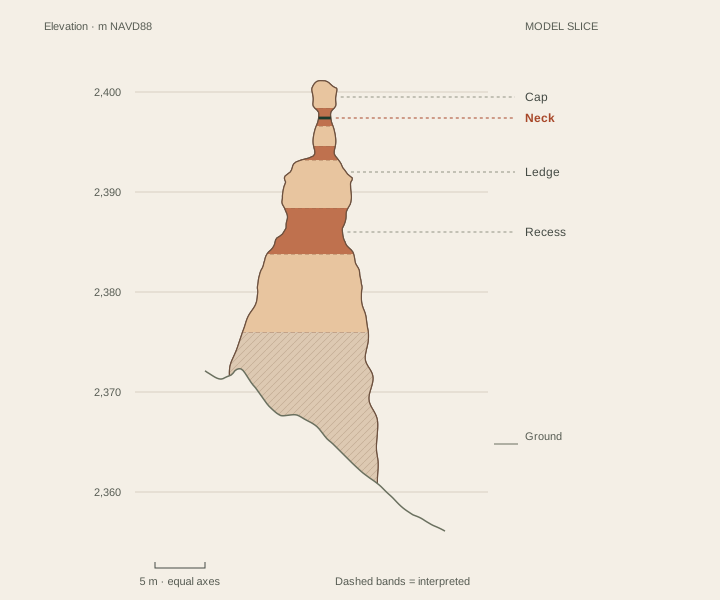
 Derived Derived shape. The copied model at an 80° section direction. Horizontal and vertical scales are equal. A green line crosses the neck.
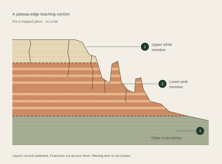 Illustration Illustrated order. This is a teaching stack, not a geologic map or a section beneath a particular viewpoint.
1. Is it a shape, a material, or a named unit?
A ledge is a shape. Limestone describes rock. Claron Formation names a rock unit that geologists recognize and map. A member is a subdivision. Those labels answer different questions; they are not interchangeable. NPS: recognizing and naming rock units.
In the local Claron sequence, the informal white member lies above the pink member where both are preserved. Bowers’s report describes variation within both. The white member is absent in some areas, and other light-colored units occur above the Claron. A pale patch in a photograph is not enough to identify a unit. NPS: member names · Bowers: report, pp. 3–4.
2. Is that a layer boundary or a fracture?
A bed records part of the sedimentary sequence. A joint cuts rock. In the weathering laboratory, the two systems cross: material differences affect which bands recede, while fractures help determine where gaps open. Real joints need not follow the neat vertical pattern used in the experiment. NPS: structures and differential erosion.
The Thor section retains bands from the earlier reconstruction: broader intervals were interpreted as more resistant and recesses as less resistant. No samples establish those assignments. Turning the bands off is a useful reminder that an outline is an observation of shape, while resistance is an explanation to investigate.
3. What part of the history is missing?
A gap in the rock record can reflect erosion or nondeposition. A neat stack can hide that missing time. Bowers describes the conglomerate at Boat Mesa resting across an erosional break, locally over different Claron members. The layer diagram leaves this and other younger deposits out; it does not represent every place at Bryce.
Older regional rocks beneath the Claron record other environments. They are grouped here rather than squeezed into a false inventory. Continue to the Grand Staircase field note for the broad regional relationship.
How old is the rock, and how old is its shape?
These are separate questions. Agency introductions use different age ranges and geographic scopes. The recent UGS synthesis discusses Early Eocene evidence near Bryce and older possible ages farther west. We use relative order here, not a precise date for each band. These rocks also record streams, floodplains, lakes and soil development, rather than one unchanging lake. Knudsen, 2024, stratigraphic discussion on p. 12. That report maps Parowan; it is not a new map of Bryce.
How this section was made
The outline is a vertical intersection through the cap center of the existing BCC reconstruction. It uses 0.2 m model rows and 120 angular samples, with linear interpolation between them. Model spacing is not survey accuracy. The ground is interpolated from the copied 0.2 m model grid. Horizontal distances and NAVD88 elevations are in meters, with equal axes.
The underlying source is 2018 USGS 3DEP airborne lidar. The earlier reconstruction adjusted neck widths from a credited NPS photograph and interpreted hidden depth; colors, fine texture and bed resistance are not measurements. This section omits the decorative surface relief. No strata are extended into the ground. The original model methods and credits still apply.
Sources & further inspection
The claim register separates source-supported facts, derived geometry and original illustrations. Sources checked October 2, 2026. Independent geology review remains open.
Primary reading and source dates
- National Park Service, Bryce Canyon National Park · Hoodoos. 2021-09-04. Weathering/erosion distinction; water and frost; depositional setting; variable resistance.
- National Park Service, Bryce Canyon National Park · Wall and Narrows. 2021-09-04. Fins bounded by fractures; runoff removes weathered fragments; differential erosion.
- National Park Service, Bryce Canyon National Park · Arches. 2015-02-24. Windows in fins; gravity; qualified bridge/arch terminology; Natural Bridge as an example.
- National Park Service, Geologic Resources Inventory · NPS Geodiversity Atlas—Bryce Canyon National Park, Utah. 2024-06-17. Joint-controlled landforms; horseshoe-shaped amphitheaters; Claron on the Paunsaugunt rim.
- US Geological Survey · Geologic map of Bryce Canyon National Park and vicinity, southwestern Utah (I-2108) — William E. Bowers. 1991 (USGS catalogue); map commonly cited as 1990. Lower pink and upper white informal members; local variation and missing white member; bed resistance interpreted in earlier field studies; contacts are not inferred from lidar.
- National Park Service, Bryce Canyon National Park · Deciphering Nature’s Palette wayside. 2024-01-08. Upper white/lower pink terminology; limestone with silt/clay and interbedded materials; introductory age range.
- Utah Geological Survey, Survey Notes 55(2) · Mapping Geologic Hazards in and Near Bryce Canyon National Park — Tyler Knudsen. 2023-05-01. Eastern escarpment, drainage contrast and active mass wasting; broad regional age range.
- Utah Geological Survey · Interim geologic map of the Parowan quadrangle, Iron County, Utah (OFR-764) — Tyler R. Knudsen. 2024. Fluvial, floodplain and lake environments; soil modification; revised local-versus-regional age interpretation. Does not supply a new Bryce geologic map.
- Science 314(5802), 1127–1129 · Bedrock Fracture by Ice Segregation in Cold Regions — Julian B. Murton, Rorik Peterson and Jean-Claude Ozouf. 2006-11-17. Ice segregation can fracture porous bedrock under experimental freezing regimes; simple freeze-count or volume-expansion explanations are incomplete.
- US Geological Survey, Geology and Ecology of National Parks · Geology of Bryce Canyon National Park. Update date not stated. Carbonate dissolution in weakly acidic water; sedimentary rock record. Loose grouping of named units in the overview is not used as a stratigraphic authority.
- National Park Service, Bryce Canyon National Park · Grand Staircase. Update date not stated. Regional sequence across Bryce, Zion and Grand Canyon; broad setting only.
- National Park Service, Geology · NPS Stratotype Inventory. Update date not stated. Hierarchy of formation, member and bed; mapping requires multiple geological properties.
Retrieval date: October 2, 2026. Media were not copied from these reading sources. The downloadable register records inherited model/asset rights separately.