Bryce field atlas · Night sky classroom

Beyond the
last light.

Learn the sky above Bryce. Turn the clock, find a familiar star, and see how one night becomes a season.

A calculated sky at Sunset Point. No weather forecast or visibility guarantee.

Eight ways to begin ↓

37.622568° N · 112.165988° W

A whole sky. One place.

Astronomical nightFacing south
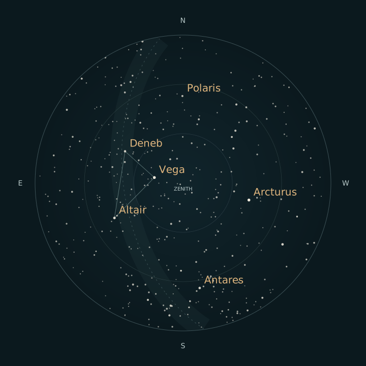
Calculated summer sky at Sunset Point on July 15, 2026, 11 p.m. MDT. The Summer Triangle is high in the east; Antares is low in the south. North is at the top, east at left, and the horizon is the outer circle.

Look up: the center is overhead. The outer circle is a level horizon.
The direction you face sits at the bottom, nearest you.

Calculated positions, with enlarged stars and a schematic Galactic plane. Terrain, clouds, haze and light pollution are not drawn.

Read this sky as a listDirections, altitudes & catalogue brightness

The interactive list appears when the catalogue has loaded. The complete seasonal guide below is available now.

The seasonal observing guide

Eight ways
into the night.

Begin with your own eyes. These short lessons work with the explorer, on paper, or as questions to carry outside.

Save the printable guide (PDF)
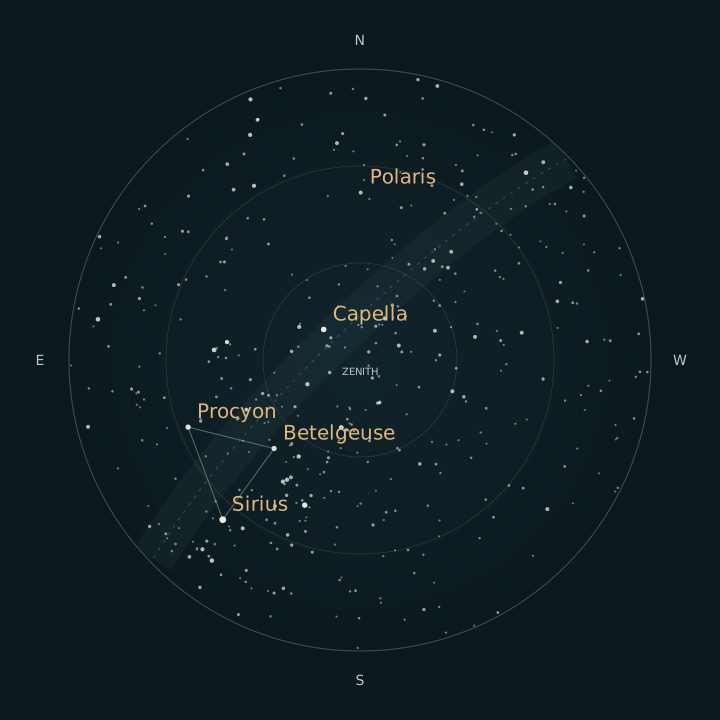
Calculated January evening sky at Bryce, with Sirius, Betelgeuse and Procyon forming the Winter Triangle in the southeast and south.
Derived Winter · January 15, 9 p.m. MST2026-01-16 04:00 UTC · north at top
Calculated July evening sky at Bryce, with Vega, Deneb and Altair forming the Summer Triangle high in the east and Antares low in the south.
Derived Summer · July 15, 11 p.m. MDT2026-07-16 05:00 UTC · north at top

2026 teaching examples. These charts show stars through magnitude 4.5 for print clarity; the interactive catalogue extends to 5.5. Points and finding lines are diagrammatic. HYG 4.1 / David Nash, adapted under CC BY-SA 4.0.

Start here · any season

A horizon is not a skyline.

Learn to read the dome before looking for a constellation.

Imagine a level circle surrounding you. That is the geometric horizon: altitude 0°. The point directly overhead is the zenith, altitude 90°. A star halfway from the circle’s edge to its center is 45° above that ideal horizon. This chart looks up, so east is on your left when north is at the top.

Real trees, cliffs and distant ridges can interrupt a sightline. A star just inside this circle may still be behind your local skyline. Atmospheric refraction also shifts objects near the horizon. Neither effect is drawn here. Sunset Point supplies the published reference coordinates; it is not a promise of an unobstructed view or access at a particular hour.

All year · northern sky

Watch the sky turn.

A nearly fixed North Star makes the movement easier to see.

Earth’s rotation makes the stars appear to turn around the celestial poles. Polaris sits close to the north celestial pole, so it traces a small circle while stars farther away sweep through wider arcs. It is a useful marker of true north, but it is neither perfectly motionless nor the brightest star.

At Bryce’s latitude, the north celestial pole is about 37.6° above the level northern horizon. Stars close enough to that pole remain geometrically above the horizon throughout the day. They are called circumpolar. Daylight, weather and the landscape still affect what can actually be seen.

Winter · January evening

Find a triangle in the cold.

Sirius, Betelgeuse and Procyon frame the Winter Triangle.

An asterism is a recognizable star pattern. It can cross the boundaries of several constellations. The Winter Triangle connects Sirius, Betelgeuse and Procyon. The line segments in this chart are memory aids; the stars are not joined in space.

The example places all three above Bryce’s southeastern-to-southern horizon on a January evening. Select each star and compare the angles. Sirius has a lower catalogue magnitude than the other two, which means it appears brighter. The enlarged points make this brightness ordering easier to read, but they do not represent stellar diameters.

Spring · May evening

Follow a familiar curve.

Use the Big Dipper as a starting point for Arcturus.

The curve of the Big Dipper’s handle points toward Arcturus. You can try this familiar finding technique without needing a telescope. First identify the handle stars, then continue the curve away from the bowl. Arcturus is the bright marker you are seeking.

Now compare May with the January example at roughly the same evening hour. The star patterns retain their shapes but occupy different parts of the sky. As Earth travels around the Sun, the direction we face away from the Sun at night changes. Daily rotation and annual orbital motion work together to give every season its characteristic evening sky.

Summer · July evening

Look along our galaxy.

Three bright stars lead into a much larger structure.

Vega, Deneb and Altair belong to three different constellations: Lyra, Cygnus and Aquila. Together they form the Summer Triangle. In this July scene they make a broad pattern high across the eastern sky. Select each corner to connect the name with its direction.

The Milky Way appears as a faint band because we look through the disk of our own galaxy from inside it. Turn on the Galactic plane guide to see that disk’s orientation. The soft ribbon is a diagram around the calculated Galactic equator. Its width and glow are drawn for teaching; they are not a photograph, a map of dust lanes or a prediction of sky brightness.

Autumn · October evening

A letter changes its angle.

Cassiopeia is a useful reminder that the sky has no fixed up.

Cassiopeia’s familiar zigzag is often described as a W. During an autumn evening it stands high in the northern sky. As Earth turns, that pattern tilts; at other hours it can look like an M or a sideways zigzag. The stars have kept their arrangement while your local horizon has rotated beneath them.

Patterns help recognition, but astronomical constellations are formally defined regions of sky. People around the world have also interpreted the stars in many other ways. These few line drawings are modern finding aids, not a complete account of sky traditions or official constellation borders.

Any season · compare two nights

The Moon changes the night.

Its phase and its place in the sky answer different questions.

The Moon reflects sunlight. Its changing phase comes from the angle between the Sun, Moon and Earth, not from Earth’s shadow during an ordinary month. A near-full Moon and a thin crescent offer very different observing experiences. But phase alone does not tell you whether the Moon is above your horizon.

This explorer shows the Moon’s direction from the reference location and an approximate illuminated fraction. The fraction describes how much of the disk is sunlit; it is not a percentage of maximum brightness. The enlarged Moon marker shows position, not the disk’s shape or its orientation through a telescope.

Every evening · give darkness time

Night arrives in stages.

A dark screen cannot make a bright sky dark.

After the Sun’s center passes below a level horizon, twilight is commonly divided at solar altitudes of −6°, −12° and −18°. These are geometric definitions, not promises of when a particular star will appear. The chart hides its stars in daylight and identifies the twilight stage beside the clock.

Your eyes need time away from bright light to adapt. The National Park Service suggests allowing roughly 20–30 minutes and using a restrained red light. Try the red display here, then lower your device brightness yourself. Software color cannot control the brightness of every screen or the light spilling from other applications. Give people nearby the same chance to enjoy the dark.

Observing deck

Sixteen cards in four groups (find your bearings, follow a pattern, read the light and keep good time), each with a question, a short explanation and something to try with the sky chart above.

The cards use the same calculated sky. A star above the chart’s horizon can still be hidden by a ridge or a tree, and a calculation says nothing about tonight’s clouds.

A card chart of calculated star positions over Bryce Canyon
DerivedOne card’s chart: calculated star positions for Bryce, derived from the HYG catalog (David Nash, Astronexus, CC BY-SA 4.0). Not tonight’s sky.

Sources: David Nash, Astronexus · HYG Database 4.1 (CC BY-SA 4.0) (pinned version).

Protect the dark

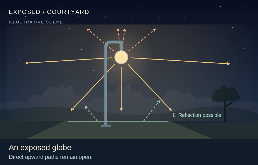
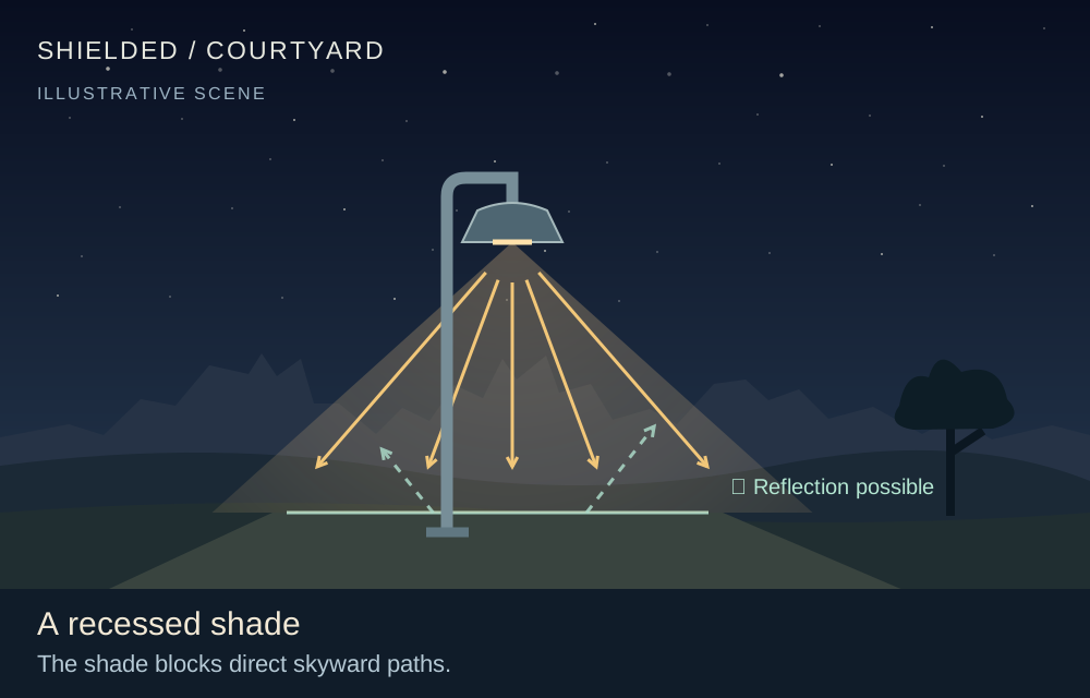
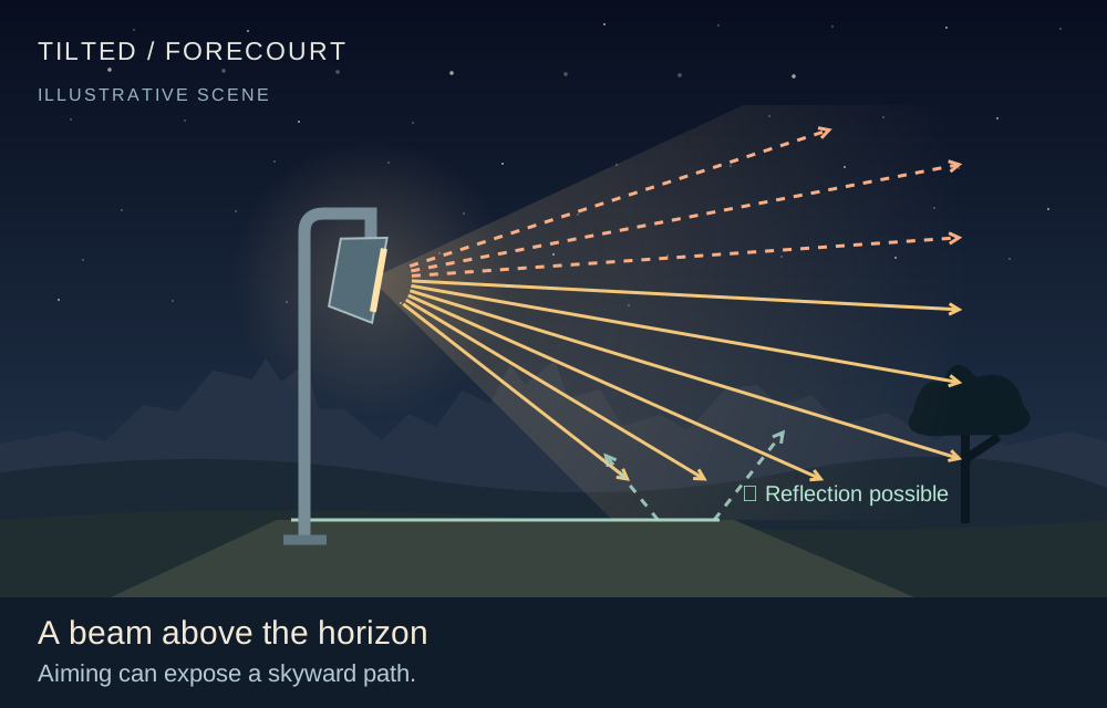
Light that escapes upward or sideways brightens the sky. The National Park Service’s outdoor lighting principles are simple: light only what needs it, only when it is needed, at the lowest useful level and a warm color, aimed down and shielded.

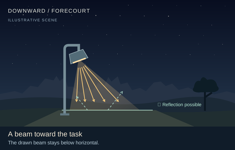
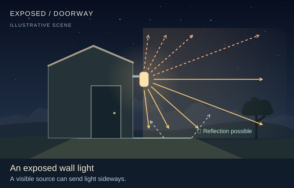
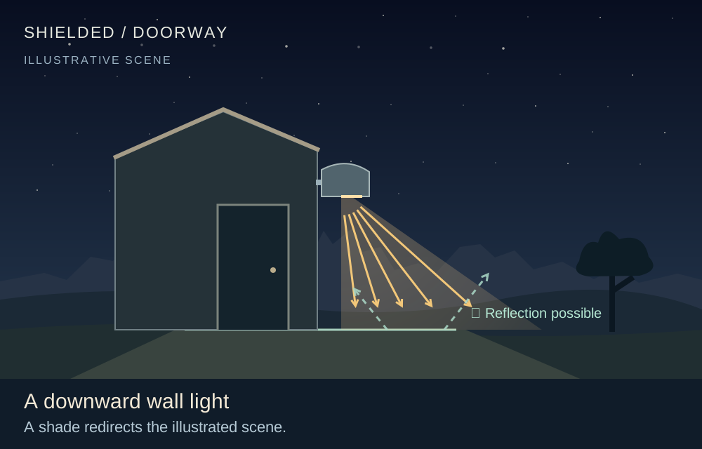
The three pairs below show what a shade or an aim changes. They are drawings, not light measurements or fixture ratings.

  • An exposed globe light sending rays up, sideways and downAn exposed globe
  • A shaded light sending its beam downwardA recessed shade
  • A tilted floodlight whose beam crosses the horizonA beam above the horizon
  • A floodlight aimed below the horizonA beam toward the task
  • A wall light sending light sidewaysAn exposed wall light
  • A shaded wall light lighting the ground by the doorA downward wall light
IllustrationThree lighting choices, each drawn two ways. Drawings by Bryce Canyon Conservancy after NPS lighting guidance (2025); the rays are schematic, not measured.

Sources: NPS · Outdoor Lighting Principles (17 June 2025); NPS · Light Pollution Sources; NPS · Light Pollution.

Life after dark

Bats, owls, a ringtail and other animals of the park are active while the sky is dark. Living Bryce follows twelve of them, from dusk to deep dark, with their park records.

The dark-sky lesson, offline

“Make room for darkness.” shows how small choices about where and when we use light help keep a view of the night. It is one file that opens without a connection, with its sources inside.

Care for the dark

Leave room for wonder.

Keep light low and directed where it is needed. Allow your eyes—and the people near you—time to adjust. The night sky is part of the landscape worth caring for.

Use NPS current conditions and the official park calendar for a real visit. A simulated star above the horizon does not establish weather, access, trail conditions or a program schedule.

Plan a visit →Return to the daylight landscape →

Sources & limits

A chart with
its workings visible.

HYG 4.1 supplies a local, curated set of 2,865 stars through visual magnitude 5.5. The downloadable catalogue retains J2000 coordinates; the explorer corrects their precession to the selected date. Point sizes show relative brightness, not physical size. Finding lines are original diagrams between catalogue positions.

The fixed reference is Sunset Point: 37.622568° N, 112.165988° W, from the NPS public point record. All inputs and displays use America/Denver; the UTC instant is always shown. Supported local dates are 2020–2035, under the browser’s current time-zone rules. Spring clock gaps are rejected; repeated autumn hours require a choice.

Broad teaching tolerances are 0.1° for stars and the Sun, 0.25° for the Moon, and 2 percentage points for the illuminated fraction. These are not survey or telescope-pointing specifications. Sun and Moon positions were checked against 678 NASA/JPL Horizons reference rows spanning the supported years; sampled maxima and assumptions are in the accuracy record.

What is included—and what remains unknown

Altitude is measured above a level geometric horizon. Azimuth runs from true north through east: north 0°, east 90°, south 180°, west 270°. The chart is an azimuthal equidistant projection looking upward; distortion increases toward its rim.

The Sun and Moon use an original implementation of published low-precision orbital formulas. The Moon includes the principal perturbations and parallax for an observer on a WGS84 reference surface at the published coordinates. Zero ellipsoid height is a simplifying calculation assumption, not Bryce’s actual elevation. That approximation is much smaller than the stated teaching tolerance.

The star model omits proper motion, nutation, aberration and stellar parallax. UTC approximates UT1, and the simplified solar/lunar model does not distinguish TT from UT. These approximations, plus reference comparisons, are documented in the accuracy record. No atmospheric refraction, terrain skyline, weather, sky-brightness model, planets, satellites, meteors, rise/set events or eclipse predictions are provided.

The Galactic plane is a calculated great circle using the ESA-documented coordinate transform. Its surrounding glow and width are illustrative. The Moon’s illuminated fraction is geocentric; direction includes observer parallax. The symbols have exaggerated sizes.

Primary references & reuse rights

Sources checked October 2, 2026. Original teaching copy and chart code; no agency photograph or third-party star-chart artwork is reproduced. The HYG subset and catalogue-derived charts are adaptations under CC BY-SA 4.0. Credit David Nash / Astronexus and retain that license when reusing them. Catalogue license · Reuse notice · Complete source ledger.

  1. HYG catalogue. David Nash · Version 4.1; repository pinned by commit. Star positions at epoch/equinox J2000.0; Apparent visual magnitude; Catalogue identities and names; Maximum omitted proper motion in the subset.
  2. NPS location. National Park Service · Live public record retrieved 2026-10-02; no source revision date asserted. Fixed published location: 37.622568244798885 N, -112.1659876923019 E.
  3. Orbital formulas. Paul Schlyter · Undated online reference; describes formulas developed in 1979 from van Flandern and Pulkkinen. Low-precision solar and lunar elements; Lunar longitude, latitude and distance perturbations; Coordinate transformations and topocentric distinction.
  4. Meeus, 1998. Jean Meeus · 1998. Mean sidereal time equation 12.4; IAU 1976 J2000-to-date precession.
  5. ERFA reference. ERFA and IAU SOFA contributors · Retrieved 2026-10-02; relevant numerical test values retained. Independent pmat76 matrix case.
  6. NASA/JPL Horizons. JPL Solar System Dynamics Group · Reference queries 2026-10-02; DE441 ephemeris. Independent Sun and Moon azimuth/altitude; Independent lunar illuminated fraction; Apparent sidereal time comparison; Airless topocentric reference conventions.
  7. ESA coordinate frame. Alexey Butkevich and Lennart Lindegren · Gaia DR3 documentation release 1.3. ICRS-to-Galactic rotation defining the Galactic equator.
  8. NPS night skies. Bryce Canyon National Park · Updated 2026-07-11. Bryce dark-sky educational context; Milky Way under clear, dark, new-Moon conditions; Light stewardship.
  9. NPS stargazing. Bryce Canyon National Park · Updated 2024-10-10. Use official calendar or visitor center for actual programs; Sunset Point is among the interpretive stargazing locations.
  10. NASA: Polaris. Preston Dyches · Published 2021-07-28; updated 2024-11-06. Polaris near the north celestial pole; Daily apparent stellar rotation; True north versus magnetic north; Big Dipper finding aid.
  11. NASA: asterisms. NASA Skywatching · Updated 2024-11-06. Summer Triangle members; Winter Triangle members; Asterisms are recognizable patterns.
  12. NASA: finding Arcturus. NASA Skywatching · 2021-09. Following the Big Dipper handle's arc to Arcturus.
  13. NASA: changing seasons. NASA / JPL-Caltech · Undated page retrieved 2026-10-02. Different evening constellations as Earth orbits the Sun.
  14. NASA: our galaxy. NASA Skywatching · Page retrieved 2026-10-02. Milky Way band as our view through the disk from within it.
  15. NASA: Cassiopeia. Hubble science team · 2018. Cassiopeia W high on autumn and winter evenings at mid-northern latitudes.
  16. NASA: lunar phases. NASA lunar science education · Page retrieved 2026-10-02. Reflected sunlight; Lunar phase geometry; Phase and time above the horizon differ.
  17. NOAA: twilight. National Weather Service, Sioux Falls · Undated page retrieved 2026-10-02. Civil, nautical and astronomical twilight boundaries at solar center altitudes -6, -12 and -18 degrees.
  18. NPS: dark adaptation. Zion National Park · Page retrieved 2026-10-02. Roughly 20–30 minutes for dark adaptation after white light; Restrained red lighting.
  19. NASA skywatching FAQ. NASA Skywatching · Page retrieved 2026-10-02. Celestial directions and observing context; Constellations versus asterisms; Sirius as brightest night-sky star; Landscape obstruction.
  20. NASA: Deneb. Kat Troche; original Night Sky Notes material · Displayed 2026-08-15. Deneb belongs to Cygnus and the Summer Triangle.
  21. NASA: Altair. Kat Troche; original Dave Prosper article · Displayed 2026-07-15; article also notes original August 2020 and update July 2025. Altair belongs to Aquila and the Summer Triangle.

No location permission, accounts or tracking. Runtime assets are local. Browser and numerical checks are not field observations, physical-device tests, assistive-user review or independent astronomer acceptance.

Bryce after dark

Read the sky, meet the animals of the night and keep the dark dark.

  1. The sky chart
  2. The observing deck
  3. Living Bryce after dark
  4. Protect the dark
  5. Outdoor lighting

UDOT reports · USGS terrain

The wider approach to Bryce

Green: reported clear · Amber: work / hazard · Red + closure symbol: closed · Gray: current status unknown

The header frames the immediate Bryce area, including US-89, SR-12 and SR-63. It is not a measured driving-time boundary. No report does not establish an open road; no live speeds or parking counts are provided. Johns Valley Road is a reference alignment; its live conditions are not connected.

UDOT Traffic ↗ · NPS park notices ↗. Background terrain is not current imagery. No claim to original U.S. Government works.

Current reports unavailable; use the official source links.

Open the complete interactive traffic map →