Field collection / Northern Bryce

Beyond the
familiar skyline.

Broad mesas. Narrow fins. A channel through the rock.

Six landscapes to turn, compare and read—with the measurements, and the missing pieces, in view.

Read the illustrated collection
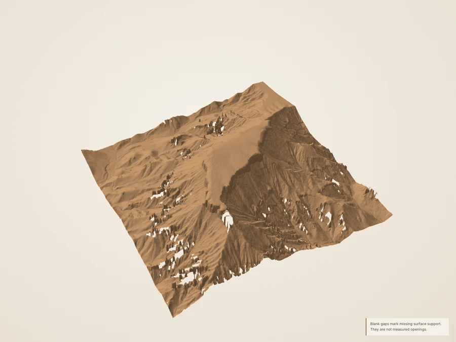
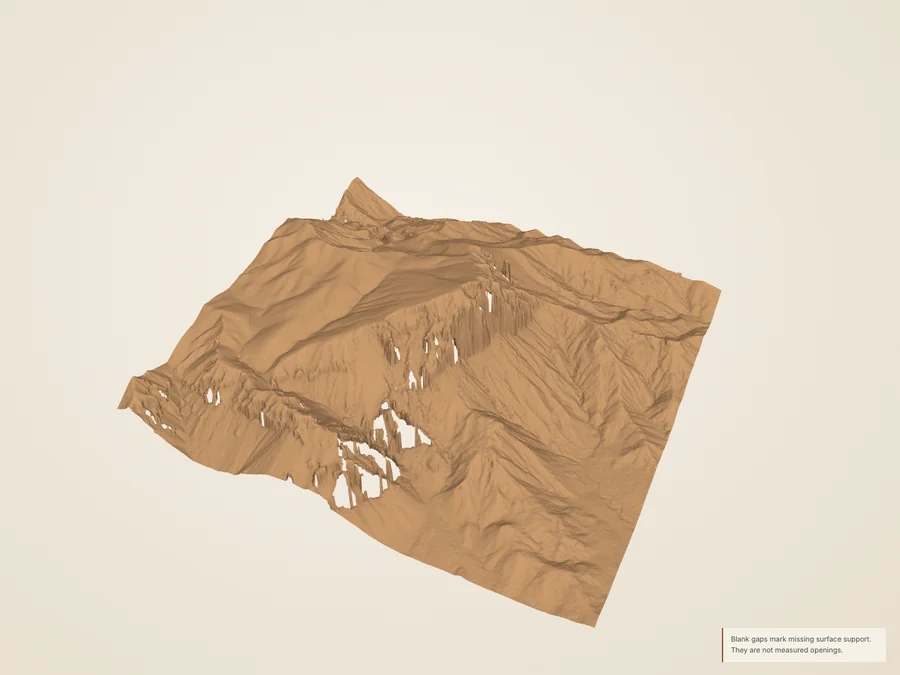
Boat Mesa and its dissected margins, shown as a source-derived terrain model.
Boat Mesa1,024 m crop · true vertical scale

The illustrated collection below works without 3D.

2018 airborne measurements; derived upper surface. Material and lighting are illustrative.

On the landscape

    Coordinates in metres: east–west and north–south on the ground, elevation up. No vertical exaggeration.

    Six distinct footprints

    A little farther north.

    Each square is a new, bounded terrain study. The older Fairyland Point crop is shown for orientation. A landscape, an overlook and a trailhead can have different locations.

    This is a locator for the collection, not a trail or access map.

    The existing Fairyland Point study ↗
    Northern collection footprintsSix numbered squares link to the studies; the dashed square is the existing Fairyland Point crop. North is up. No roads or routes are drawn.123456Fairyland PointN500 m · UTM 12N · source footprints

    The illustrated collection

    Read the shape.
    Keep the uncertainty.

    Every story includes a still, a true-scale section and its source limits. The complete guide works without interactive graphics.

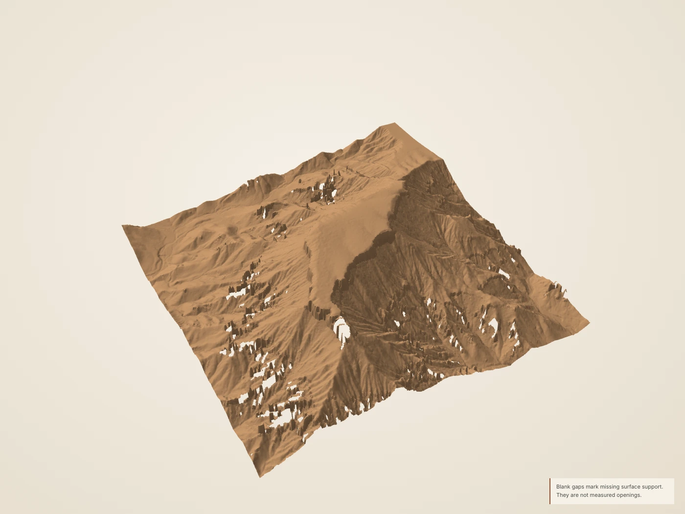
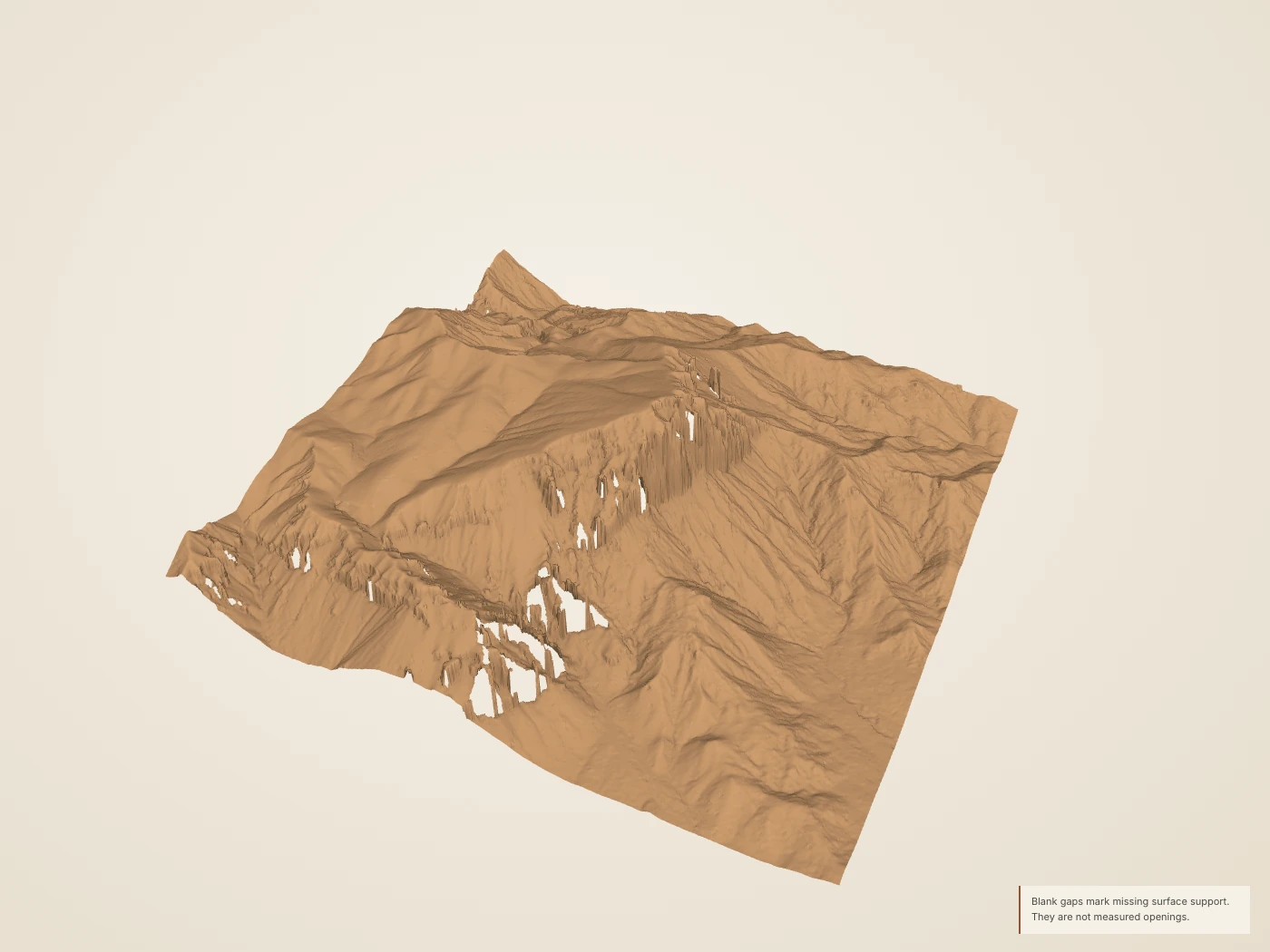
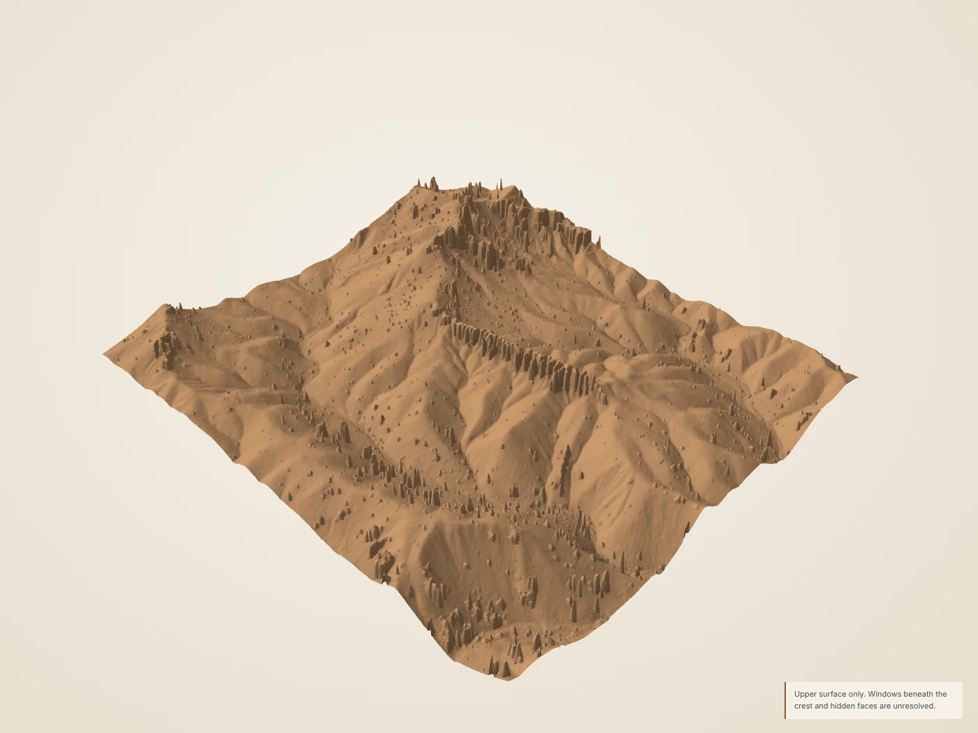
    Boat Mesa and its dissected margins, reconstructed from airborne returns. Warm material and illumination are illustrative.
    Derived Source-derived landscape · 1× vertical scale · drawn surface color. Larger still
    Static section & source coverage
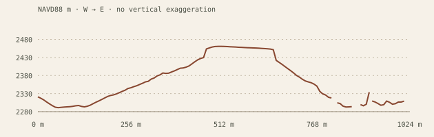
    Central west-to-east topographic section for Boat Mesa, with equal horizontal and vertical scale.
    Derived The profile shows surface shape at equal horizontal and vertical scale. It cannot show a buried contact or date erosion.
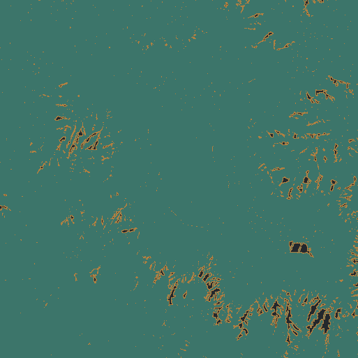
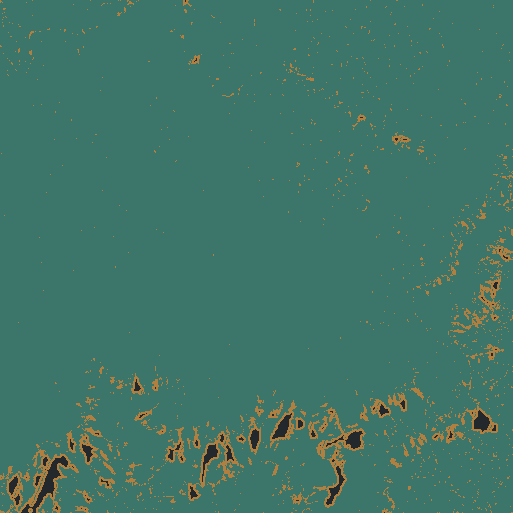
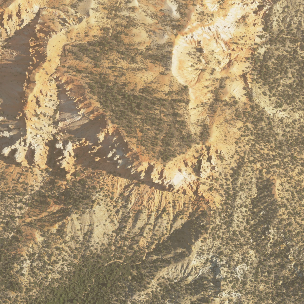
    North-up grid support for Boat Mesa: teal direct support, ochre short nearest fill, dark omitted nodes.
    Derived North up. Teal: retained return in the cell. Ochre: nearest fill within 3 m. Dark: unsupported or excluded. An observed cell does not establish hidden-wall coverage.

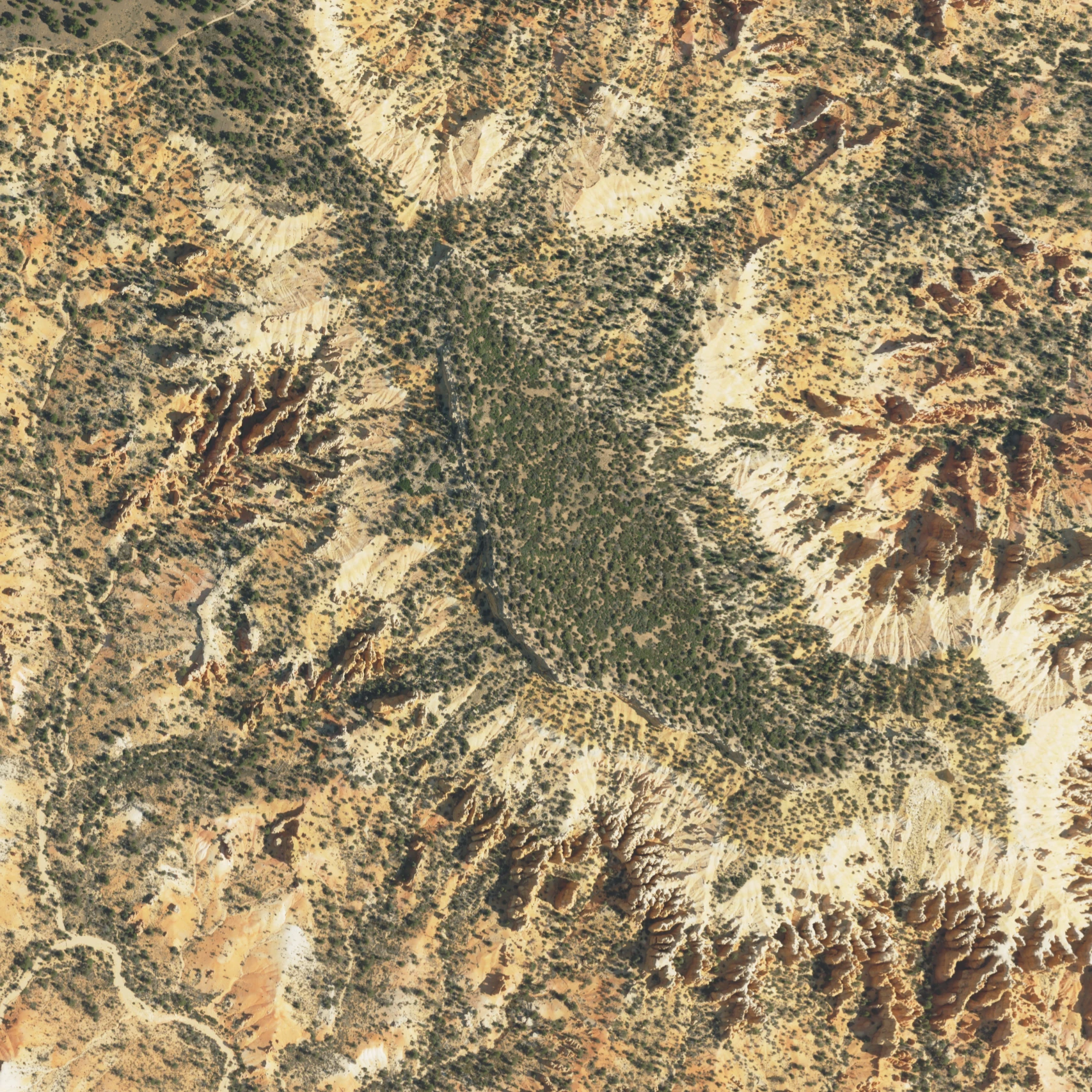
    Open the north-up NAIP image · Exact imagery record

    01 / A summit with a protective cap

    Boat Mesa

    A broad summit holds above a landscape cut into fins and hollows.

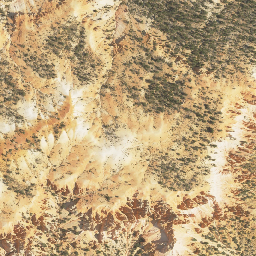
    Boat Mesa sits south of Fairyland Point. NPS describes a resistant conglomerate cap above the Claron rocks that form the surrounding hoodoos. Turn this new summit-centered crop to follow the contrast between the broad upper surface and its dissected margins.

    Read the break in the skyline. Move a west-to-east section across the mesa. A relatively gentle upper surface gives way to steeper margins, but the profile measures topography, not cap thickness. This study uses only the survey’s ground class to remove the forest canopy; compare the full return sample to see the difference.

    The source ground class can omit standing rock; hidden cliff faces remain unresolved. Published geology identifies the conglomerate, but this surface does not map its contact or measure cap thickness.

    Measured extent, resolution & source record
    Footprint
    1,024 × 1,024 m. Editorial crop, not a feature boundary.
    Returns
    37,786,985 usable returns; 36.04 returns/m². Density is not an accuracy claim.
    Detail grids
    8.0 / 4.0 / 2.0 m. Nested samples of the same surface.
    Coverage
    95.41% direct fine-grid support before exclusions; 3.67% short nearest fill. 0.92% omitted after masks.
    Elevation
    2222.5–2463.5 m NAVD88 in the reconstructed crop; 1× vertical scale.
    Coordinates
    Source native NAD83(2011) / UTM 12N; public EPT in EPSG:3857; export in WGS84 / UTM 12N. Z retained as NAVD88 / Geoid12B. No survey-grade datum alignment asserted.
    Photograph
    USDA NAIP, 2024-07-23; 0.6 m source pixels, shown separately from the 2018 surface.

    USGS geographic names: northern Bryce landforms · Fairyland Point

    Complete model packet · Source objects and hashes · High-detail glTF (.gz, 6.49 MB)
    Turn this landscape

    Boat Mesa: photograph, history and walks

    The Sinking Ship crop in oblique relief, with the surrounding slopes at true vertical scale.
    Derived Source-derived landscape · 1× vertical scale · drawn surface color. Larger still
    Static section & source coverage
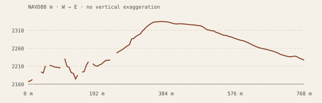
    Central west-to-east topographic section for Sinking Ship, with equal horizontal and vertical scale.
    Derived Compare the surface profile with the NPS interpretation. The model has no measured bedding orientations.
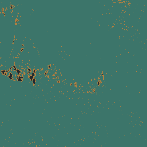
    North-up grid support for Sinking Ship: teal direct support, ochre short nearest fill, dark omitted nodes.
    Derived North up. Teal: retained return in the cell. Ochre: nearest fill within 3 m. Dark: unsupported or excluded. An observed cell does not establish hidden-wall coverage.

    Open the north-up NAIP image · Exact imagery record

    02 / A tilted skyline

    Sinking Ship

    A slanting skyline stands apart from the larger plateau edge.

    NPS relates Sinking Ship’s tilted appearance to faulting along the eastern edge of the park. This separate crop isolates the formation and the slopes around it. Its shape can be compared with Boat Mesa without mistaking the two features for different views of the same model.

    A slope is not a rock-bed angle. Rotate to the other side, then inspect a section. This study follows the survey’s ground class to avoid treating forest canopy as rock. A ground slope is not automatically the dip of a rock bed, the angle of a fault, or the amount of displacement.

    The ground class can omit standing rock. No fault plane, bed orientation or contact is inferred from this terrain. Published fault interpretation and measured modern topography are different evidence.

    Measured extent, resolution & source record
    Footprint
    768 × 768 m. Editorial crop, not a feature boundary.
    Returns
    18,433,800 usable returns; 31.25 returns/m². Density is not an accuracy claim.
    Detail grids
    6.0 / 3.0 / 1.5 m. Nested samples of the same surface.
    Coverage
    96.92% direct fine-grid support before exclusions; 2.53% short nearest fill. 0.55% omitted after masks.
    Elevation
    2110.1–2344.7 m NAVD88 in the reconstructed crop; 1× vertical scale.
    Coordinates
    Source native NAD83(2011) / UTM 12N; public EPT in EPSG:3857; export in WGS84 / UTM 12N. Z retained as NAVD88 / Geoid12B. No survey-grade datum alignment asserted.
    Photograph
    USDA NAIP, 2024-07-24; 0.6 m source pixels, shown separately from the 2018 surface.

    USGS geographic names: northern Bryce landforms · Fairyland Point

    Complete model packet · Source objects and hashes · High-detail glTF (.gz, 6.48 MB)

    Turn this landscape

    Sinking Ship: photograph, history and walks

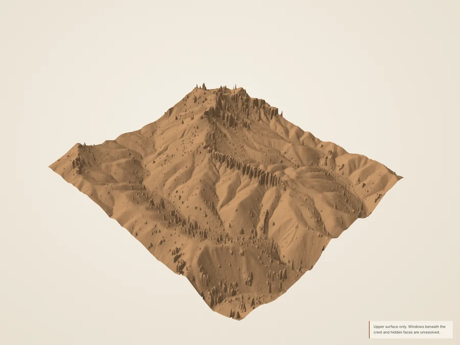
    The China Wall landscape study. Thin crests are limited by the grid and the airborne view.
    Derived Source-derived landscape · 1× vertical scale · drawn surface color. Larger still
    Static section & source coverage
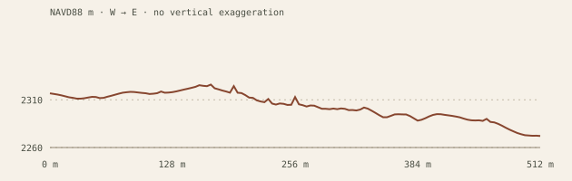
    Central west-to-east topographic section for China Wall, with equal horizontal and vertical scale.
    Derived A thin ridge can look continuous from one angle and broken from another. Returns and the source photograph help expose the limits of the surface.
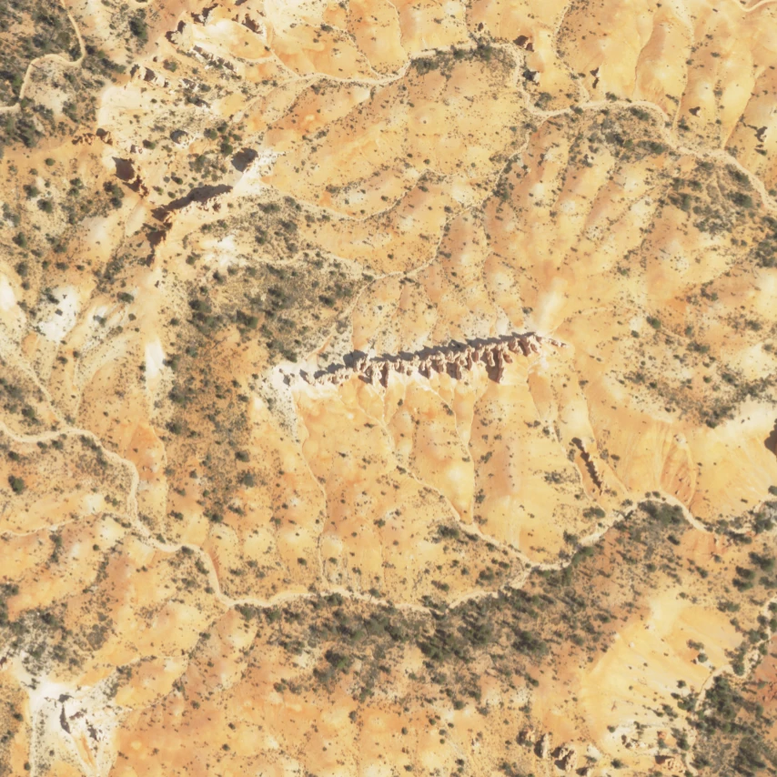
    North-up grid support for China Wall: teal direct support, ochre short nearest fill, dark omitted nodes.
    Derived North up. Teal: retained return in the cell. Ochre: nearest fill within 3 m. Dark: unsupported or excluded. An observed cell does not establish hidden-wall coverage.

    Open the north-up NAIP image · Exact imagery record

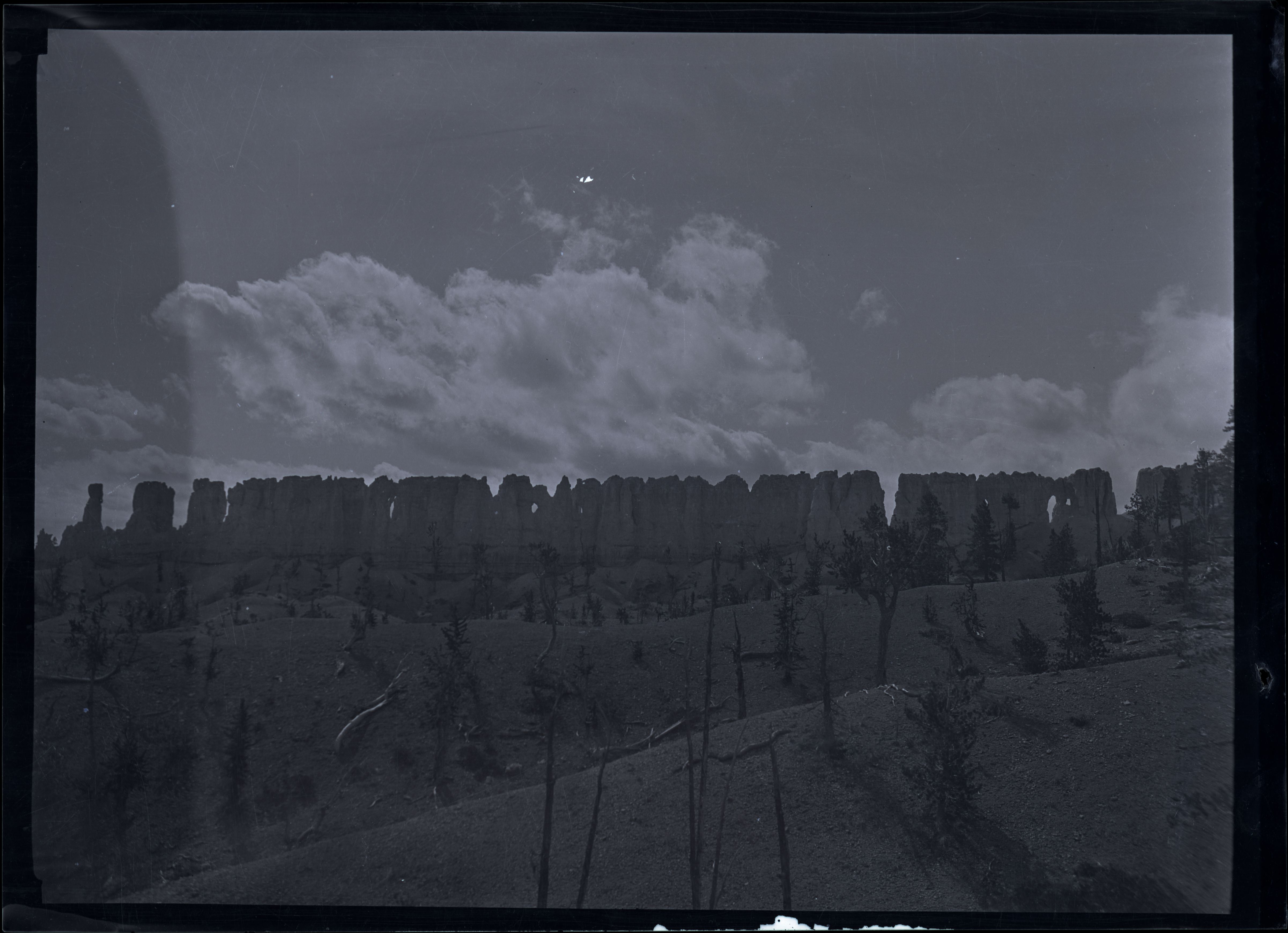
    Historical black-and-white photograph of China Wall from Fairyland Loop, by Maurice Cope.
    Separate historical reference; capture date not established. Courtesy Bryce Canyon National Park, Photographer Maurice Cope, Museum Catalog Number BRCA 532/001-#191. Public domain. Rights and original record. No calibrated before/after or change-rate claim.

    03 / A ridge narrowed into a wall

    China Wall

    A long, narrow ridge makes the transition from wall to separate towers legible.

    NPS archives call this feature China Wall; the USGS geographic names record uses Chinese Wall. The study preserves both names. USGS describes Bryce’s thin divides as remnants between eroding gullies. Here, viewing across the ridge and along it reveals very different silhouettes.

    Follow the wall, then cross it. Switch between the reconstructed surface and measured returns. A broad ridge is better constrained than a thin crest. The historical NPS photograph provides an independent view of the feature; it supplies neither hidden geometry nor a calibrated change measurement.

    A narrow fin can be broadened by grid sampling, and gaps beneath a crest remain unresolved. The historical photograph is a separate reference, never a model texture or evidence of a measured erosion rate.

    Measured extent, resolution & source record
    Footprint
    512 × 512 m. Editorial crop, not a feature boundary.
    Returns
    7,212,433 usable returns; 27.51 returns/m². Density is not an accuracy claim.
    Detail grids
    4.0 / 2.0 / 1.0 m. Nested samples of the same surface.
    Coverage
    99.91% direct fine-grid support before exclusions; 0.09% short nearest fill. 0.00% omitted after masks.
    Elevation
    2246.0–2368.4 m NAVD88 in the reconstructed crop; 1× vertical scale.
    Coordinates
    Source native NAD83(2011) / UTM 12N; public EPT in EPSG:3857; export in WGS84 / UTM 12N. Z retained as NAVD88 / Geoid12B. No survey-grade datum alignment asserted.
    Photograph
    USDA NAIP, 2024-07-23; 0.6 m source pixels, shown separately from the 2018 surface.

    USGS geographic names: northern Bryce landforms · China Wall from Fairyland Loop: archival photograph · Geologic map of Bryce Canyon National Park and vicinity: explanatory report

    Complete model packet · Source objects and hashes · High-detail glTF (.gz, 6.27 MB)

    Turn this landscape

    China Wall: photograph, history and walks

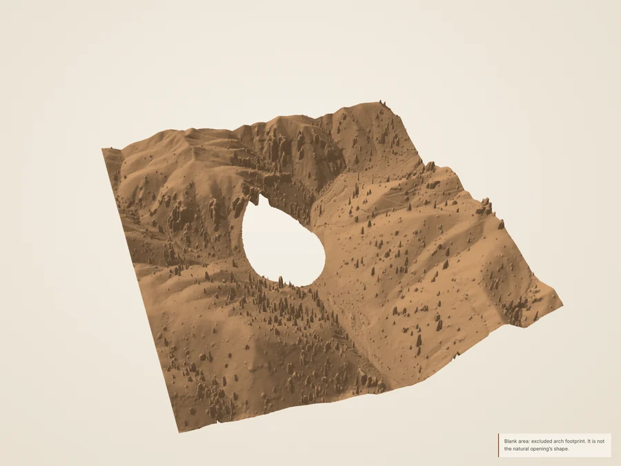
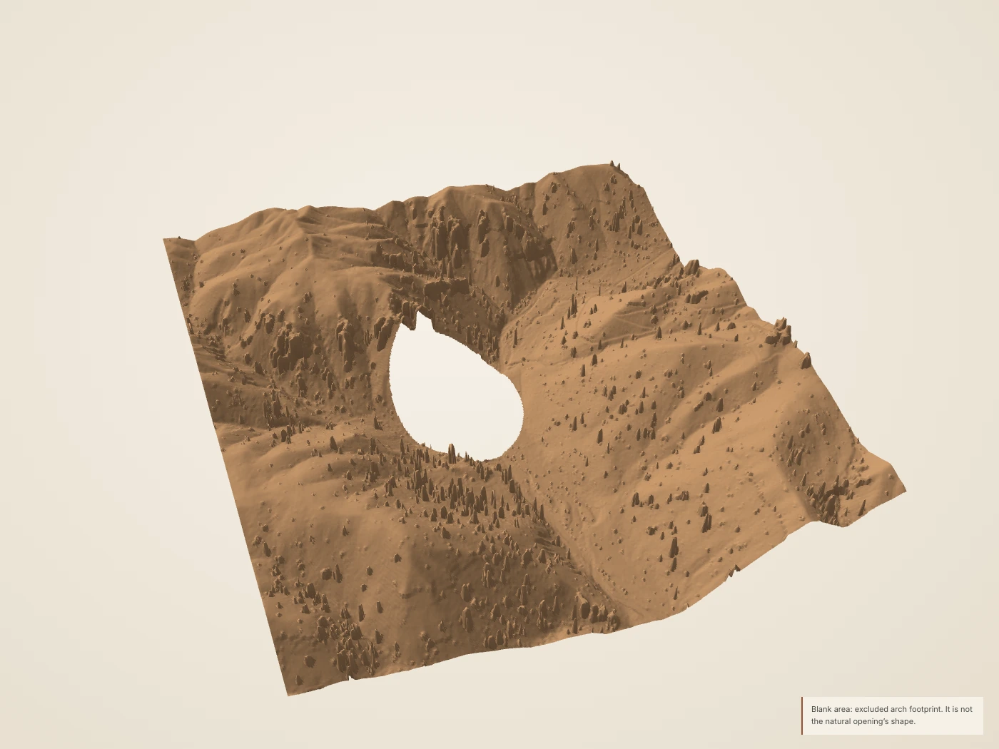
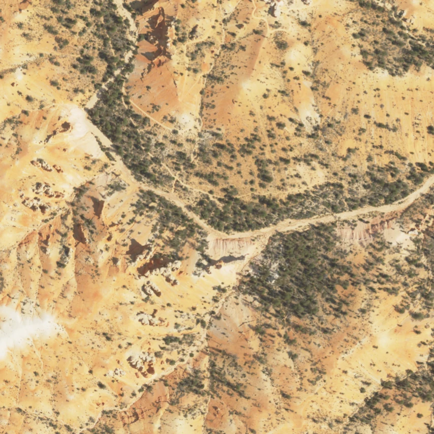
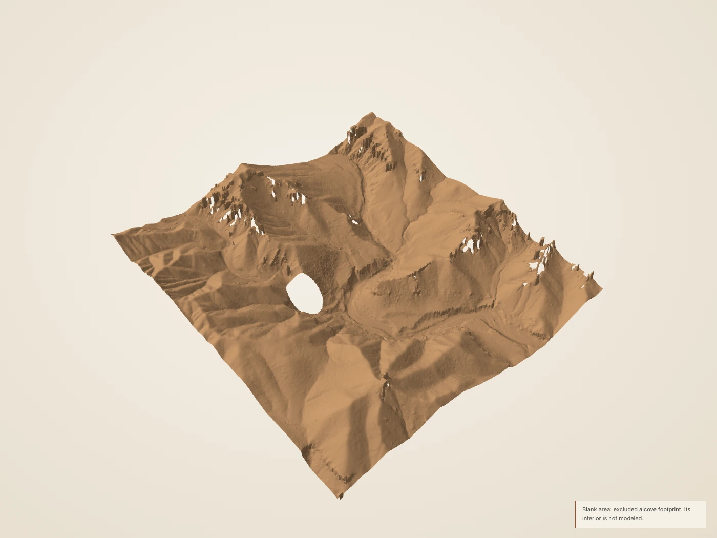
    Landscape around Tower Bridge. The deliberate opening in this model marks excluded, unresolved arch geometry; it is not a model of the natural opening.
    Derived Source-derived landscape · 1× vertical scale · drawn surface color. Larger still
    Static section & source coverage
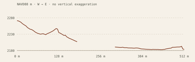
    Central west-to-east topographic section for Around Tower Bridge, with equal horizontal and vertical scale.
    Derived The return sample preserves measured positions inside the omitted area. Scattered overhead returns do not establish a complete underside.
    North-up grid support for Around Tower Bridge: teal direct support, ochre short nearest fill, dark omitted nodes.
    Derived North up. Teal: retained return in the cell. Ochre: nearest fill within 3 m. Dark: unsupported or excluded. An observed cell does not establish hidden-wall coverage.

    Open the north-up NAIP image · Exact imagery record

    04 / Landscape around an unseen opening

    Around Tower Bridge

    The surrounding ridges are visible from above. The arch’s underside needs a different survey.

    Tower Bridge is a named hoodoo reached from the southern part of Fairyland Loop. This exhibit studies its surrounding terrain. A deliberate gap removes the arch area from the surface so an overhead grid cannot quietly turn the opening into solid rock.

    An honest gap in the surface. Use the return view to inspect what the aircraft actually recorded, then switch back to coverage. The gap is an uncertainty mask, not the shape of the real opening. A ground scan would need converging views of the pillars, openings and underside.

    Tower Bridge itself is not reconstructed. The conservative exclusion includes disagreement between published locator roles. NPS’s viewpoint and trailhead are separate from the named rock and are not substituted for it.

    Measured extent, resolution & source record
    Footprint
    512 × 512 m. Editorial crop, not a feature boundary.
    Returns
    7,940,567 usable returns; 30.29 returns/m². Density is not an accuracy claim.
    Detail grids
    4.0 / 2.0 / 1.0 m. Nested samples of the same surface.
    Coverage
    99.76% direct fine-grid support before exclusions; 0.24% short nearest fill. 5.02% omitted after masks.
    Elevation
    2177.5–2294.4 m NAVD88 in the reconstructed crop; 1× vertical scale.
    Coordinates
    Source native NAD83(2011) / UTM 12N; public EPT in EPSG:3857; export in WGS84 / UTM 12N. Z retained as NAVD88 / Geoid12B. No survey-grade datum alignment asserted.
    Photograph
    USDA NAIP, 2024-07-23; 0.6 m source pixels, shown separately from the 2018 surface.

    Tower Bridge · NPS public points of interest · Tower Bridge and Mossy Cave named locators

    Complete model packet · Source objects and hashes · High-detail glTF (.gz, 6.28 MB)

    Turn this landscape

    Tower Bridge: photograph, history and walks

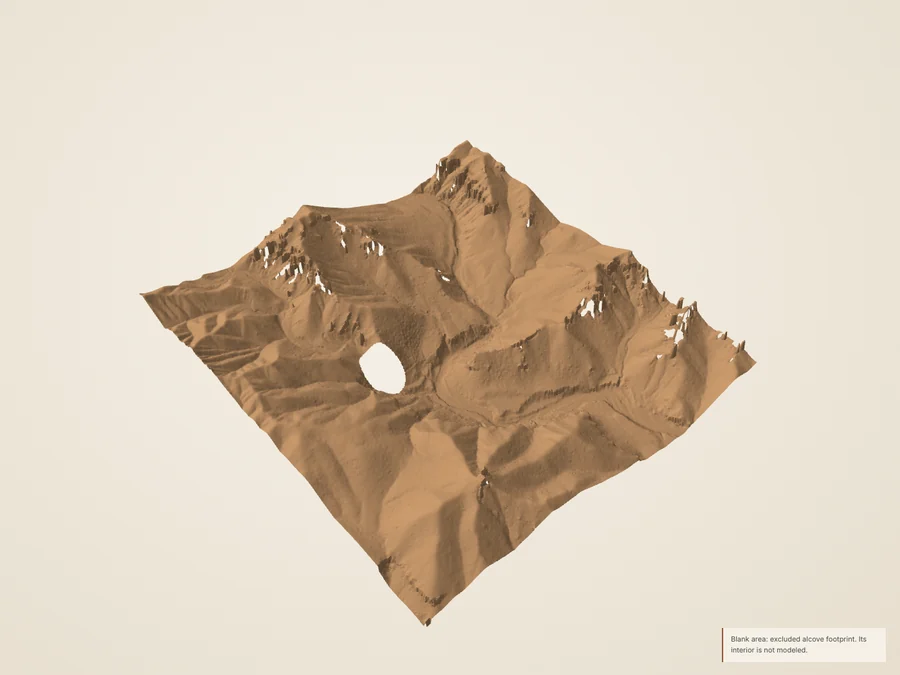
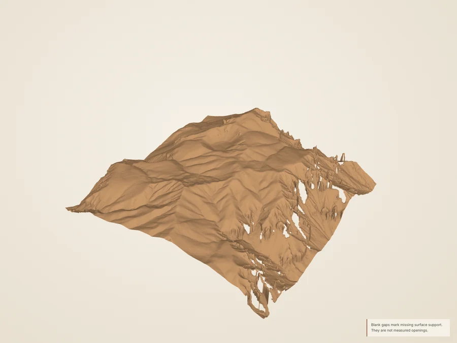
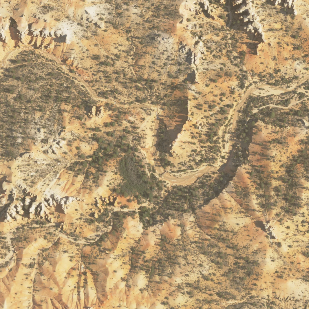
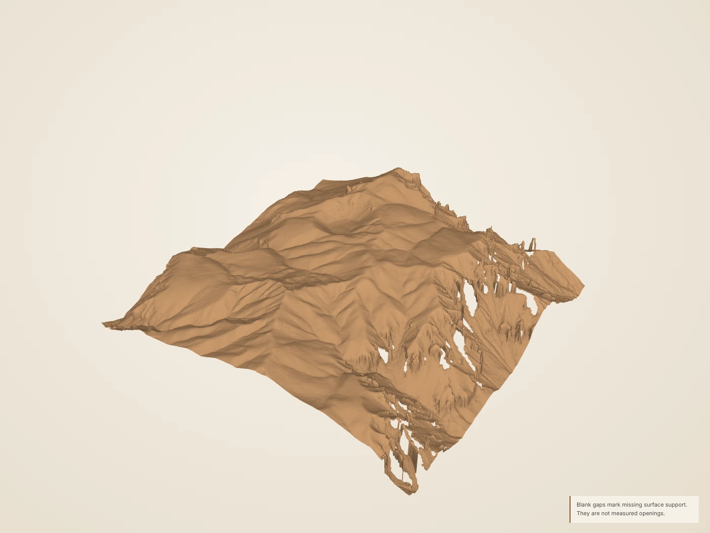
    The Water Canyon landscape around Mossy Cave and the waterfall. The alcove footprint is omitted rather than closed by a height surface.
    Derived Source-derived landscape · 1× vertical scale · drawn surface color. Larger still
    Static section & source coverage
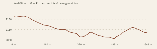
    Central west-to-east topographic section for Mossy Cave drainage, with equal horizontal and vertical scale.
    Derived The marked waterfall is a mapped location, not a surveyed crest or drop-height measurement. The alcove’s missing surface is a coverage limit.
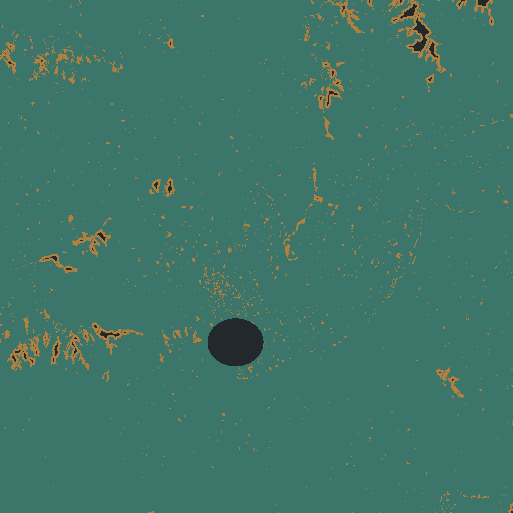
    North-up grid support for Mossy Cave drainage: teal direct support, ochre short nearest fill, dark omitted nodes.
    Derived North up. Teal: retained return in the cell. Ochre: nearest fill within 3 m. Dark: unsupported or excluded. An observed cell does not establish hidden-wall coverage.

    Open the north-up NAIP image · Exact imagery record

    05 / A channel through Water Canyon

    Mossy Cave drainage

    A narrow watercourse cuts through the northern hoodoo landscape.

    The Mossy Cave trail follows Water Canyon. NPS describes the Tropic Ditch, completed in 1892, as bringing irrigation water through this canyon. The waterfall, the alcove and the trailhead occupy different places; this study keeps them distinct.

    Separate channel, waterfall and alcove. Compare the north-up aerial image with the ground-class terrain section. The channel’s surrounding slopes may be measured even where water, vegetation and the cliff below a fall are poorly sampled. No moving water or present-day flow is simulated.

    The alcove and overhang are deliberately omitted. Neither its interior nor the waterfall’s vertical face, water depth or current flow is reconstructed. NPS asks visitors to protect the alcove and stay out of it.

    Measured extent, resolution & source record
    Footprint
    640 × 640 m. Editorial crop, not a feature boundary.
    Returns
    11,125,384 usable returns; 27.16 returns/m². Density is not an accuracy claim.
    Detail grids
    5.0 / 2.5 / 1.25 m. Nested samples of the same surface.
    Coverage
    96.53% direct fine-grid support before exclusions; 3.15% short nearest fill. 1.12% omitted after masks.
    Elevation
    2078.6–2214.0 m NAVD88 in the reconstructed crop; 1× vertical scale.
    Coordinates
    Source native NAD83(2011) / UTM 12N; public EPT in EPSG:3857; export in WGS84 / UTM 12N. Z retained as NAVD88 / Geoid12B. No survey-grade datum alignment asserted.
    Photograph
    USDA NAIP, 2024-07-24; 0.6 m source pixels, shown separately from the 2018 surface.

    Mossy Cave / Water Canyon · Mossy Cave wayside · NPS public points of interest

    Complete model packet · Source objects and hashes · High-detail glTF (.gz, 6.34 MB)

    Turn this landscape

    Mossy Cave and Water Canyon: photograph, history and walks

    The isolated Bristlecone Point landscape study, distinct from the southern Bristlecone Loop.
    Derived Source-derived landscape · 1× vertical scale · drawn surface color. Larger still
    Static section & source coverage
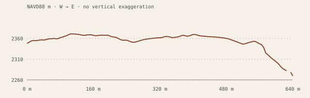
    Central west-to-east topographic section for Bristlecone Point, with equal horizontal and vertical scale.
    Derived Sections measure modern surface form. They do not establish a walkable line, vegetation species or the underlying stratigraphy.
    North-up grid support for Bristlecone Point: teal direct support, ochre short nearest fill, dark omitted nodes.
    Derived North up. Teal: retained return in the cell. Ochre: nearest fill within 3 m. Dark: unsupported or excluded. An observed cell does not establish hidden-wall coverage.

    Open the north-up NAIP image · Exact imagery record

    06 / A ridge between drainages

    Bristlecone Point

    A separate ridge rises between the surrounding hollows.

    USGS identifies Bristlecone Point east of the main amphitheater. Two published summit locators fall within this crop. The exhibit follows the ridge’s topographic form, complementing Boat Mesa’s broader upper surface without implying that a place name identifies the trees visible today.

    A ridge rather than a route. Move the section from north to south and compare the ridge width and neighboring lows. The surface uses the survey’s ground class; the full return view includes vegetation. Display categories do not identify species.

    This is Bristlecone Point, not Bristlecone Loop near Rainbow Point. The ground class may omit standing rock; no tree species, tree age, trail or rock contact is inferred.

    Measured extent, resolution & source record
    Footprint
    640 × 640 m. Editorial crop, not a feature boundary.
    Returns
    12,260,086 usable returns; 29.93 returns/m². Density is not an accuracy claim.
    Detail grids
    5.0 / 2.5 / 1.25 m. Nested samples of the same surface.
    Coverage
    94.63% direct fine-grid support before exclusions; 4.37% short nearest fill. 1.01% omitted after masks.
    Elevation
    2216.6–2378.6 m NAVD88 in the reconstructed crop; 1× vertical scale.
    Coordinates
    Source native NAD83(2011) / UTM 12N; public EPT in EPSG:3857; export in WGS84 / UTM 12N. Z retained as NAVD88 / Geoid12B. No survey-grade datum alignment asserted.
    Photograph
    USDA NAIP, 2024-07-23; 0.6 m source pixels, shown separately from the 2018 surface.

    USGS geographic names: northern Bryce landforms · The geology of the Grand Staircase in southern Utah: a road log and guide for public school teachers

    Complete model packet · Source objects and hashes · High-detail glTF (.gz, 6.38 MB)

    Turn this landscape

    Bristlecone Point, the northern ridge: photograph, history and walks

    From measurements to a surface

    Detail begins
    with evidence.

    The source is a 2018 USGS airborne survey. Boat Mesa, Sinking Ship, Mossy Cave drainage, Bristlecone Point use the survey’s ground class to omit canopy; this class can also omit standing rock. China Wall, Around Tower Bridge follow a filtered upper surface, retaining narrow standing forms but potentially leaving vegetation remnants. Missing nodes may borrow a nearest sample up to 3 m away; larger gaps remain open. Three nested grids provide different delivery sizes, not three different surveys.

    Return density includes multiple echoes and overlapping flight lines. It does not measure accuracy or tell us whether an aircraft saw beneath an overhang. The point view preserves a deterministic sample of the original measured positions, including vegetation candidates.

    The 13-candidate coverage ledger · All six model records

    A gap can be the right answer.

    The Tower Bridge arch and Mossy Cave alcove are excluded from the terrain surfaces. Their masks are conservative editorial boundaries, not measured opening outlines. No provenance-verified ground scan was obtained for these features in the public-source audit.

    USDA NAIP photographs show the landscape from above in 2024. They appear only as separate north-up evidence views. The 2018 geometry, later tree cover, shadows and metre-scale registration differences remain visible limits.

    These historical studies cannot establish current conditions, a walkable route, an erosion rate or a future collapse. Protect fragile rock and stay on designated routes; consult current NPS information when planning a visit.

    Primary sources, rights & credits
    1. USGS geographic names: northern Bryce landforms — US Geological Survey / National Geospatial Program. Official names and published locators for Boat Mesa, Sinking Ship, Chinese Wall, Bristlecone Point and audited alternatives. Name points are not surveyed feature boundaries. US Government Public Domain. Retrieved October 2, 2026.
    2. Fairyland Point — National Park Service. Boat Mesa conglomerate cap, Sinking Ship fault interpretation, Fairyland and Campbell Canyon context. No numeric erosion age/rate derived here. Paraphrased government text; page photographs not copied. Retrieved October 2, 2026.
    3. Tower Bridge — National Park Service. Official identity and relation to southern Fairyland Loop; not a ground-scan record. Paraphrased government text; no photograph copied. Retrieved October 2, 2026.
    4. Mossy Cave / Water Canyon — National Park Service. Water Canyon identity, Tropic Ditch completion in 1892 and irrigation context. Historical description does not establish current flow. Paraphrased government text; no photograph copied. Retrieved October 2, 2026.
    5. Mossy Cave wayside — National Park Service. Alcove formation by seeping water and protection request to remain outside. Paraphrased government text; no photograph copied. Retrieved October 2, 2026.
    6. NPS public points of interest — NPS National Geospatial Program. Distinct waterfall, cave, viewpoint and trailhead roles. Waterfall 1994 and cave 5289 agree closely with independently mapped OSM positions. Tower viewpoint 4362 is distinct from the rock locator. Unrestricted public government mapping; source methods retained; no claim to original US Government works. Retrieved October 2, 2026.
    7. Tower Bridge and Mossy Cave named locators — OpenStreetMap contributors. Tower Bridge node 391696698; comparison points for Mossy Cave and Tropic Ditch Falls. These do not replace NPS arrival points. ODbL 1.0; copyright OpenStreetMap contributors. Retrieved October 2, 2026.
    8. China Wall from Fairyland Loop: archival photograph — Bryce Canyon National Park Museum and Archives. Independent oblique reference and NPS name China Wall. Capture date and camera calibration are not established; not used for mesh geometry, texture or change-rate measurement. Public domain; mandatory credit: Courtesy Bryce Canyon National Park, Photographer Maurice Cope, Museum Catalog Number BRCA 532/001-#191. Retrieved October 2, 2026.
    9. Geologic map of Bryce Canyon National Park and vicinity: explanatory report — US Geological Survey. Thin divides, ridges and hoodoos between eroding gullies; named Chinese Wall and Tower Bridge. Historical numerical erosion estimates are not used in this product. US Government Public Domain. Retrieved October 2, 2026.
    10. The geology of the Grand Staircase in southern Utah: a road log and guide for public school teachers — USGS-hosted GSA 2002 Rocky Mountain Section field guide. Regional map identity for Bristlecone Point and northern landmarks; no modern route or operational status inferred. Reference only; no third-party chapter map or photograph reproduced. Hosting on a government domain is not used as a copyright determination.. Retrieved October 2, 2026.
    11. USGS 3DEP lidar, UT Southern QL1 2018 — USGS; public EPT organization by Hobu. Independent measured airborne returns; per-model acquisition record retains every source object URL and hash. US Government Public Domain. Retrieved October 2, 2026.
    12. National Agriculture Imagery Program imagery — USDA FPAC / Farm Service Agency. Rights and orthorectified aerial imagery; used only in north-up evidence views, never wall photographs. US Government Public Domain, dataset-specific public-domain label. Retrieved October 2, 2026.
    13. Utah NAIP specifications — Utah Geospatial Resource Center. Utah 2024 NAIP at 0.6 m source resolution; +/-4 m stated horizontal accuracy. Export sampling is not a new accuracy claim. Reference only. Retrieved October 2, 2026.
    14. OpenTopography public dataset catalog — OpenTopography. 804 records searched. The one Bryce keyword match is a 2016 airborne Straight Cliffs survey east of these targets, not a north-landmark ground scan. Metadata review only; no scan copied. Retrieved October 2, 2026.

    Map services and data available from U.S. Geological Survey, National Geospatial Program. Aerial imagery: USDA Farm Service Agency / FPAC, NAIP. Tower Bridge’s named rock locator: © OpenStreetMap contributors, ODbL 1.0. NPS records retain their separate coordinate roles.

    Rendering: Three.js, MIT license. Existing site fonts and identity retain their original credits. No agency endorsement or affiliation is implied. Machine-readable source ledger · Site methods and credits

    UDOT reports · USGS terrain

    The wider approach to Bryce

    Green: reported clear · Amber: work / hazard · Red + closure symbol: closed · Gray: current status unknown

    The header frames the immediate Bryce area, including US-89, SR-12 and SR-63. It is not a measured driving-time boundary. No report does not establish an open road; no live speeds or parking counts are provided. Johns Valley Road is a reference alignment; its live conditions are not connected.

    UDOT Traffic ↗ · NPS park notices ↗. Background terrain is not current imagery. No claim to original U.S. Government works.

    Current reports unavailable; use the official source links.

    Open the complete interactive traffic map →