Find a way in. Follow the rim. Leave a little more room for the view.
One scenic road, a shuttle around the amphitheater, and four airport starting points. Explore the distances and stops before opening current directions.
The interactive map is loading. The complete reading guide is available below, including directions and every stop.
Your planned arrival points
Arrival points from your itinerary, in order. A hike leads to its access point; this list does not calculate a driving route or confirm current access.
NPS recommends driving south to Rainbow and Yovimpa, then stopping at the southern viewpoints on the return north. Those pullouts are on your right as you return.
18 mi / 29 km one way on the main park road. About 36 mi / 58 km out and back, before side roads.
Road length from NPS; round trip and kilometers are derived. No drive time is estimated. NPS scenic-drive guidance ↗
Yovimpa is a walk from the Rainbow Point road-end area; Piracy Point is a walk from Farview. The list describes stop order, not turns or permission to enter a road.
Keep it with you
A guide beyond the map.
All stops, airport comparisons and practical notes are available here without the interactive map.
The park shuttle connects the Visitor Center, Bryce, Inspiration, Sunset and Sunrise Points, the Lodge, and stops outside the park. It does not reach the Southern Scenic Drive, Fairyland Point, Paria View or Mossy Cave.
The published 2026 season is April 3–October 18. Service can change; check current hours and last buses with NPS. A dated season does not mean a bus is operating now.
Park admission covers shuttle use. NPS describes wheelchair-accessible buses. Pets are not permitted; check NPS service-animal guidance. The Rainbow Bus Tour is not offered in the checked guidance.
Vehicles 23 feet (7 m) or longer face parking restrictions during shuttle hours at the Visitor Center’s one-hour lot, the Lodge, Sunrise, Sunset, Inspiration and Bryce Points. Paria View restricts these vehicles at all hours.
NPS recommends the Shuttle Station in Bryce Canyon City or the Additional Parking Lot across from the Visitor Center. Ordinary vehicles may also benefit from the shuttle. The southern drive has different parking rules and no park shuttle; follow signs.
Fairyland and Paria spur roads close to vehicles in winter. After snowstorms, the main road can close beyond mile 3 while crews clear the southern drive. This map does not determine whether any road or trail is open.
Check NPS alerts for park restrictions and UDOT for Utah highways and construction. Do not substitute a drawn road for an open route. Ask a ranger about hiking conditions.
The map works after its local assets have loaded, with no account or location permission. External directions and current condition pages need a connection. Save this reading guide or print it before leaving coverage; a cold visit to an uncached site may not load offline.
Airport mileage comes from NPS’s directions page: LAS and SLC about 270 miles, SGU 125, CDC 80. Exact routes can differ. The airport view’s dashed connector is illustrative and has no navigable geometry. No flights, car availability, traffic or drive times are asserted.
Approximately 270 mi / 435 km to the park — the NPS comparison, not a calculated route length or a travel-time estimate.
I-15 north → UT-20 east → US-89 south → UT-12 east → UT-63 south.
Public airport address: 5757 Wayne Newton Boulevard, Las Vegas, Nevada 89119. Confirm the actual terminal or rental-car origin in the provider. Airport reference pin: FAA / BTS data effective September 3, 2026.
This written approach comes from NPS’s Bear (Dog) Valley guidance. Mileage depends on the chosen route. A Zion alternative has separate park, tunnel and vehicle considerations.
Directions: airport → Visitor Center. The provider chooses the road route.
Salt Lake City International Airport
SLC · Airport origin
Approximately 270 mi / 435 km to the park — the NPS comparison, not a calculated route length or a travel-time estimate.
I-15 south → UT-20 east → US-89 south → UT-12 east → UT-63 south.
Public airport address: 3920 W. Terminal Dr., Salt Lake City, Utah 84122. Confirm the actual terminal or rental-car origin in the provider. Airport reference pin: FAA / BTS data effective September 3, 2026.
Use the airport’s current terminal and ground-transport instructions to reach the highway.
Directions: airport → Visitor Center. The provider chooses the road route.
St. George Regional Airport
SGU · Airport origin
Approximately 125 mi / 201 km to the park — the NPS comparison, not a calculated route length or a travel-time estimate.
Join I-15 north → UT-20 east → US-89 south → UT-12 east → UT-63 south.
Public airport address: 4550 S Airport Parkway, St. George, Utah 84790. Confirm the actual terminal or rental-car origin in the provider. Airport reference pin: FAA / BTS data effective September 3, 2026.
NPS’s 125-mile figure is a broad comparison, not the measured length of this corridor; the provider may choose a different route.
Directions: airport → Visitor Center. The provider chooses the road route.
Cedar City Regional Airport
CDC · Airport origin
Approximately 80 mi / 129 km to the park — the NPS comparison, not a calculated route length or a travel-time estimate.
NPS describes UT-14 east → US-89 north → UT-12 east → UT-63 south.
Public airport address: 2560 W. Aviation Way, Cedar City, Utah 84720. Confirm the actual terminal or rental-car origin in the provider. Airport reference pin: FAA / BTS data effective September 3, 2026.
UT-14 is a mountain approach. Check UDOT conditions. NPS also describes the longer I-15 / UT-20 approach; 80 miles does not represent every alternative.
A rim viewpoint near the start of the Queen’s Garden Trail.
Shuttle destination: 13. Place pins do not mark exact boarding points.
NPS describes a 0.2-mile walk from the shuttle stop to the viewpoint. Vehicles 23 feet (7 m) or longer: use alternate parking and the shuttle during shuttle hours.
Shuttle destination: 11. Place pins do not mark exact boarding points.
Use the marked path from parking or the shuttle stop to the rim. Vehicles 23 feet (7 m) or longer: use alternate parking and the shuttle during shuttle hours.
A sequence of views across the Bryce Amphitheater.
Shuttle destination: 9. Place pins do not mark exact boarding points.
The mapped point does not describe the grade or accessibility of every viewpoint. Consult NPS access information. Vehicles 23 feet (7 m) or longer: use alternate parking and the shuttle during shuttle hours.
A broad amphitheater view at the end of a spur road.
Shuttle destination: 8. Place pins do not mark exact boarding points.
Park or leave the shuttle at the designated area and walk to the viewpoint. Vehicles 23 feet (7 m) or longer: use alternate parking and the shuttle during shuttle hours.
Numbering follows the NPS page checked October 2, 2026. The list is not a live timetable. Boarding locations and operating hours must be confirmed with NPS.
Shuttle Station · departure
Old Bryce Town · inbound
Best Western+ Grand Hotel · inbound
Best Western+ Ruby’s Inn · inbound
Ruby’s Campground · southbound
Visitor Center · southbound
Sunset Campground · southbound
Bryce Point · loop
Inspiration Point · loop
Sunset Campground · northbound
Sunset Point · northbound
Bryce Canyon Lodge · northbound
Sunrise Point · northbound
Visitor Center · northbound
Ruby’s Campground · northbound
Printable maps
Eight map sheets for the day, from the long view of the park road to Mossy Cave in its separate northern corner, in three paper sizes. Each sheet is drawn from National Park Service road, trail and point records and prints its own coverage limits.
They are planning sheets, not navigation or current-condition maps: roads and trails outside a sheet’s frame are left out, and some point locations are accurate only to 14 metres or worse.
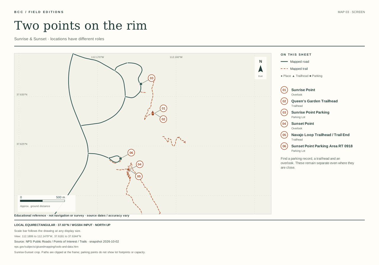
DerivedSheet 03, Sunrise and Sunset, drawn by Bryce Canyon Conservancy from NPS public road, trail and point records retrieved 2 October 2026.
One sheet at a time
01 · The long viewBryce Canyon · selected roads & overlooks. Selected park road corridor. No park boundary, terrain, complete road network or trail network shown. (165 KB)
02 · Around the amphitheaterSix places along the northern rim. Northern amphitheater crop. Selected named trail records only; no complete connected walking route. (138 KB)
03 · Two points on the rimSunrise & Sunset · locations have different roles. Sunrise-Sunset crop. Paths are clipped at the frame; parking points do not show lot footprints or capacity. (59 KB)
04 · Two overlook approachesBryce Point & Inspiration Point. Two overlook approaches. Point symbols are locations, not feature footprints; no grades or access conditions. (57 KB)
05 · Fairyland, in contextRoad, rim and recorded trail fragments. Fairyland area crop. The NPS snapshot has incomplete named trail coverage; this is not a full-loop route guide. (86 KB)
06 · Along the southern roadSwamp Canyon to the southern rim. Southern road corridor only. Selected overlooks; no complete road network, turn guidance or current conditions. (99 KB)
07 · At the southern rimRainbow, Yovimpa & the Bristlecone area. Southern rim crop. Some point accuracy is 14 m or worse; trails extending outside the frame are incomplete here. (29 KB)
08 · A separate northern cornerMossy Cave · four distinct source locations. Mossy Cave crop, separate from the main road corridor. No stream geometry, flow, hazard or access status shown. (31 KB)
Road centerlines and place locations come from NPS, approach highways from UDOT, and airport reference points from FAA / BTS. The USGS background is shaded elevation, not aerial photography. Accuracy and source dates vary; these are planning-scale data.
In the airport view, a dashed line only connects an origin to Bryce. It is not a driving route. NPS airport mileages are broad comparisons, independent of that line. Current routes, travel times and restrictions belong to your navigation provider and the relevant road authority.
The park map omits administrative roads. A line or pin does not establish access, an open road, available parking or a step-free walk. Check NPS conditions and UDOT Traffic before departure.
Source review: October 2, 2026. No live feeds, geolocation, tracking, login, remote tiles or paid map service. Once loaded, the map can be explored without a connection; external directions need a network. Save the standalone guide before leaving coverage. Independent of the National Park Service.
Source ledger, dates and reuse notes
Directions ↗National Park Service · retrieved 2026-10-02 · source date 2024-05-01Airport-to-park approximate mileage, approach roads, one visitor-center destination.Factual summary of NPS visitor guidance; no photographs or agency marks reused.
Southern Scenic Drive Viewpoints ↗National Park Service · retrieved 2026-10-02 · source date 2024-04-09One main entrance/exit, 18-mile main road, 3-mile amphitheater area, northbound return-stop recommendation and scenic order.Factual summary of NPS visitor guidance; no photographs or agency marks reused.
Park Shuttle ↗National Park Service · retrieved 2026-10-02 · publication date not established2026 season, numbered stop sequence, recommended parking, access and oversize-vehicle restrictions.Factual summary of NPS visitor guidance; no photographs or agency marks reused.
Parking Information ↗National Park Service · retrieved 2026-10-02 · publication date not establishedSouthern drive has no shuttle; parking-area coordinates and oversize parking context. Live/predicted occupancy is not imported.Factual summary of NPS visitor guidance; no photographs or agency marks reused.
Visiting in Winter ↗National Park Service · retrieved 2026-10-02 · source date 2024-03-05Fairyland and Paria winter vehicle closures; temporary storm closure beyond mile 3.Factual summary of NPS visitor guidance; no photographs or agency marks reused.
Current Conditions ↗National Park Service · retrieved 2026-10-02 · source date 2026-08-31Official current alerts and road/trail condition handoff. No status is cached as live.Factual summary of NPS visitor guidance; no photographs or agency marks reused.
Visitor Center ↗National Park Service · retrieved 2026-10-02 · publication date not establishedVisitor information and facilities; check current hours.Factual summary of NPS visitor guidance; no photographs or agency marks reused.
Mossy Cave Trail ↗National Park Service · retrieved 2026-10-02 · source date 2024-10-10Separate UT-12 trailhead, no park shuttle, use designated parking and return later if full; no highway shoulder parking.Factual summary of NPS visitor guidance; no photographs or agency marks reused.
Park Brochure ↗National Park Service · retrieved 2026-10-02 · publication date not establishedPark orientation and approach context; no agency map, image, or third-party photograph reproduced.Factual summary of NPS visitor guidance; no photographs or agency marks reused.
NPS Public Roads — BRCA subset ↗NPS National Geospatial Program · retrieved 2026-10-02 · publication date not establishedMapped road centerlines, explicitly selected visitor corridors. Source accuracy/date often unknown.NPS/FHWA government data; public-domain government work. NPS terms and per-feature provenance retained in geometry.json. No claim to original U.S. Government works.
NPS Public Points of Interest — BRCA subset ↗NPS National Geospatial Program · retrieved 2026-10-02 · publication date not establishedPublic viewpoint, trailhead and visitor-facility coordinates. Not parking guidance or live access.Public-domain NPS government data, with underlying source methods retained. No agency imagery is copied. No claim to original U.S. Government works.
NPS ownership and reuse ↗National Park Service · retrieved 2026-10-02 · source date 2025-03-05Government-work reuse basis and third-party/agency-mark exceptions.Factual summary of NPS visitor guidance; no photographs or agency marks reused.
NPS geospatial data disclaimers ↗National Park Service · retrieved 2026-10-02 · source date 2024-08-14Public distribution terms; data are neither legal documents nor warranted as accurate.Factual summary of NPS visitor guidance; no photographs or agency marks reused.
USGS 3DEP Bare Earth DEM Dynamic service ↗U.S. Geological Survey · retrieved 2026-10-02 · source date 2026-08-25Small multidirectional hillshade export; illustrative illumination derived from elevation.Public-domain USGS-produced data; credit USGS National Map 3DEP. Unmodified exported JPEG; opacity/tint supplied by CSS, no photographic texture.
USGS copyrights and credits ↗U.S. Geological Survey · retrieved 2026-10-02 · publication date not establishedUSGS-produced data reuse and required third-party distinctions.Reference only; no third-party media reused.
UDOT Routes ALRS ↗Utah Department of Transportation / GIS · retrieved 2026-10-02 · source date 2026-06-24Selected Utah highway alignments for overview context, not a connected routing graph.Public UDOT informational-use dataset; item-specific disclaimer retained in NOTICE.txt. Do not infer UGRC CC BY terms for this externally hosted dataset.
UDOT Traffic ↗Utah Department of Transportation · retrieved 2026-10-02 · publication date not establishedCurrent Utah road conditions, construction and restrictions; external handoff only.Link and factual description only.
Aviation Facilities — LAS, SLC, SGU, CDC ↗Federal Aviation Administration; distributed by USDOT Bureau of Transportation Statistics · retrieved 2026-10-02 · source date 2026-09-03Airport reference coordinates and identifiers, effective 2026-09-03. Not terminal, rental-car, or aviation navigation coordinates.Service metadata explicitly grants unrestricted public use of U.S. government work; no U.S. copyright. No claim to original U.S. Government works.
Harry Reid International Airport ↗Airport authority / municipal operator · retrieved 2026-10-02 · publication date not establishedOfficial airport identity and public address: 5757 Wayne Newton Boulevard, Las Vegas, Nevada 89119. Current ground-transport information belongs to the airport.Names, addresses and links only; no photographs, logos, schedules, fares or flight claims copied.
Salt Lake City International Airport ↗Airport authority / municipal operator · retrieved 2026-10-02 · publication date not establishedOfficial airport identity and public address: 3920 W. Terminal Dr., Salt Lake City, Utah 84122. Current ground-transport information belongs to the airport.Names, addresses and links only; no photographs, logos, schedules, fares or flight claims copied.
St. George Regional Airport ↗Airport authority / municipal operator · retrieved 2026-10-02 · publication date not establishedOfficial airport identity and public address: 4550 S Airport Parkway, St. George, Utah 84790. Current ground-transport information belongs to the airport.Names, addresses and links only; no photographs, logos, schedules, fares or flight claims copied.
Cedar City Regional Airport ↗Airport authority / municipal operator · retrieved 2026-10-02 · publication date not establishedOfficial airport identity and public address: 2560 W. Aviation Way, Cedar City, Utah 84720. Current ground-transport information belongs to the airport.Names, addresses and links only; no photographs, logos, schedules, fares or flight claims copied.
Maps URLs ↗Google · retrieved 2026-10-02 · publication date not establishedDocumented keyless direction-link syntax; no Google routes or data acquired.Documentation reference only.
Map Links ↗Apple · retrieved 2026-10-02 · publication date not establishedDocumented Apple Maps direction-link parameters.Documentation reference only.
NPS place: Fairyland Point ↗National Park Service · retrieved 2026-10-02 · source date October 10, 2024Place identity, location and visitor-access description; milepost where stated.Factual summary of NPS visitor guidance; no photographs or agency marks reused.
NPS place: Sunset Point ↗National Park Service · retrieved 2026-10-02 · source date August 15, 2026Place identity, location and visitor-access description; milepost where stated.Factual summary of NPS visitor guidance; no photographs or agency marks reused.
NPS place: Inspiration Point ↗National Park Service · retrieved 2026-10-02 · source date January 2, 2025Place identity, location and visitor-access description; milepost where stated.Factual summary of NPS visitor guidance; no photographs or agency marks reused.
NPS place: Bryce Point ↗National Park Service · retrieved 2026-10-02 · source date October 10, 2024Place identity, location and visitor-access description; milepost where stated.Factual summary of NPS visitor guidance; no photographs or agency marks reused.
NPS place: Paria View ↗National Park Service · retrieved 2026-10-02 · source date October 10, 2024Place identity, location and visitor-access description; milepost where stated.Factual summary of NPS visitor guidance; no photographs or agency marks reused.
NPS place: Swamp Canyon ↗National Park Service · retrieved 2026-10-02 · source date August 15, 2026Place identity, location and visitor-access description; milepost where stated.Factual summary of NPS visitor guidance; no photographs or agency marks reused.
NPS place: Farview Point ↗National Park Service · retrieved 2026-10-02 · source date February 1, 2021Place identity, location and visitor-access description; milepost where stated.Factual summary of NPS visitor guidance; no photographs or agency marks reused.
NPS place: Piracy Point ↗National Park Service · retrieved 2026-10-02 · source date January 28, 2021Place identity, location and visitor-access description; milepost where stated.Factual summary of NPS visitor guidance; no photographs or agency marks reused.
NPS place: Natural Bridge ↗National Park Service · retrieved 2026-10-02 · source date August 15, 2026Place identity, location and visitor-access description; milepost where stated.Factual summary of NPS visitor guidance; no photographs or agency marks reused.
NPS place: Agua Canyon ↗National Park Service · retrieved 2026-10-02 · source date August 31, 2026Place identity, location and visitor-access description; milepost where stated.Factual summary of NPS visitor guidance; no photographs or agency marks reused.
NPS place: Ponderosa Canyon ↗National Park Service · retrieved 2026-10-02 · source date October 10, 2024Place identity, location and visitor-access description; milepost where stated.Factual summary of NPS visitor guidance; no photographs or agency marks reused.
NPS place: Black Birch Canyon ↗National Park Service · retrieved 2026-10-02 · source date October 10, 2024Place identity, location and visitor-access description; milepost where stated.Factual summary of NPS visitor guidance; no photographs or agency marks reused.
NPS place: Rainbow Point ↗National Park Service · retrieved 2026-10-02 · source date August 15, 2026Place identity, location and visitor-access description; milepost where stated.Factual summary of NPS visitor guidance; no photographs or agency marks reused.
NPS place: Yovimpa Point ↗National Park Service · retrieved 2026-10-02 · source date October 10, 2024Place identity, location and visitor-access description; milepost where stated.Factual summary of NPS visitor guidance; no photographs or agency marks reused.
Twenty-three places from Mossy Cave to Riggs Spring, each with its photograph, terrain, canyon section, early photographs, best light, walks and sources.

 Derived