Home Conservation Open data Conservancy · Open data
Open data The Bryce datasets behind this site, with their sources, licenses, dates, sizes and checksums. Everything here is free to download; keep the credits and, for the star catalog, its share-alike license.
16 datasets Each entry carries one evidence label; how to read the labels . Sizes and checksums are computed when the site is built.
Terrain for 20 places, three detail levels Surface models for the eight amphitheater and south-rim places, six northern places and six southern places, each at three levels of detail, with aerial color and a measured section.
Class Derived from measured lidar
Format glTF (gzip), poster images, section SVG, JSON records
Size 214.9 MB · 313 files
Date Lidar acquired 2018 (published 2019); models built from it, sources checked 2 October 2026
Source and license USGS 3DEP UT Southern QL1 2018 lidar point cloud; U.S. Government public domain. Aerial color: USDA NAIP; public domain.
sha256 of a sorted list of 313 file digests 1fb9838bb3a20bac551b67c3fdd5451c5f17b38ab8176a69b21e1d4109fad2f5Fixed samples of the laser returns behind each terrain model, kept separate from the surfaces built from them, plus four northern evidence packets.
Class Measured
Format glTF point sets (gzip), JSON packets
Size 28.2 MB · 24 files
Date Acquired 2018 (published 2019); sampled October 2026
Source and license USGS 3DEP UT Southern QL1 2018; U.S. Government public domain.
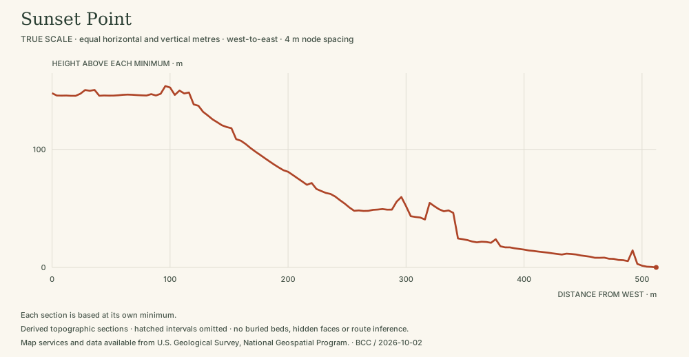
sha256 of a sorted list of 24 file digests 3817696232be77131e0ee5a325160291d765636cfdfc2c6e69fe5d2bda28a258Twelve straight-line elevation profiles across Bryce canyons, each with its sample spacing, vertical exaggeration and data gaps.
Class Derived from measured lidar
Format JSON, SVG
Size 333 KB · 37 files
Date Lidar acquired 2018; sections derived October 2026
Source and license Derived from USGS 3DEP 2018 lidar; U.S. Government public domain. Drawings: Bryce Canyon Conservancy.
sha256 of a sorted list of 37 file digests d1fc06ec020c13def67ec09e06d331018ecfb5e9dddd6213f0c622b84d9237bbThe near horizon seen from eight overlooks, drawn from the terrain model as silhouettes and plans.
Class Derived from measured lidar
Format SVG, JSON
Size 1.8 MB · 24 files
Date Lidar acquired 2018; skylines derived October 2026; sources checked 2 October 2026
Source and license Derived from USGS 3DEP 2018 lidar; U.S. Government public domain. Drawings: Bryce Canyon Conservancy.
sha256 of a sorted list of 24 file digests 21b799e97f5320c237c0e2d51b3ab187ac6c7a4a55b0ec555f7a1dcd8c05a3cfRelief in text and print, six sectors Accessible descriptions and print plates of the relief in six sectors of the rim, for reading Bryce without 3D.
Class Derived from measured lidar
Format JSON, SVG, text
Size 2.6 MB · 26 files
Date Lidar acquired 2018; packets derived October 2026
Source and license Derived from USGS 3DEP 2018 lidar; U.S. Government public domain. Text and plates: Bryce Canyon Conservancy.
sha256 of a sorted list of 26 file digests 6a65bdef0120c6afb6ce9dd755394c7e9f80e506feeaae751580aeb59aaeab52Twelve trails and elevation profiles Route lines assembled from identified Utah and NPS trail records, with elevation profiles sampled from lidar.
Class Mapped route records with derived profiles
Format GeoJSON, CSV, JSON
Size 2.4 MB · 53 files
Date Trail records updated 2021–2026; sources checked 2 October 2026
Source and license Utah Geospatial Resource Center and NPS trail records (public); elevations from USGS 3DEP. See the sources in each route file.
sha256 of a sorted list of 53 file digests ea80271dc35beed1e88afcc4a3028e9762ce9192ea24b6619ba02cfda93c37b1Park destinations, roads and shuttle stops Viewpoints, trailheads, facilities, the park road and shuttle stops used by the map and the visit planner.
Class Mapped from agency records
Format JSON
Size 512 KB · 4 files
Date Sources checked 2 October 2026
Source and license National Park Service and Utah Department of Transportation records; see data/travel/sources.json.
sha256 of a sorted list of 4 file digests b8bfcf1513d06ed045da244c64e66f36b0931810d45a853d41453c93feeaa68fClimate normals, park headquarters and airport, 1991–2020 Monthly temperature, precipitation and snowfall normals for two Bryce stations, with every value’s NOAA quality flag. Normals are long-term averages, not a forecast.
Class Statistical summary of measurements
Format JSON
Size 30 KB · 1 file
Date Normals period 1991–2020; retrieved 2 October 2026
Source and license NOAA National Centers for Environmental Information; U.S. Government public domain.
sha256 of the file c07267b48ce48e22bba44a8847d0b2e46fba9e9018dc7cb4f6b80bb84e87ef0fStar catalog subset, 2,865 stars The stars drawn on the night-sky chart, with positions and brightness taken from the HYG catalog.
Class Catalog-derived
Format JSON
Size 164 KB · 2 files
Date HYG version 4.1; retrieved 2 October 2026
Source and license HYG database 4.1 (Astronexus), CC BY-SA 4.0. Derived data must keep the same license; see HYG-LICENSE.txt.
sha256 of a sorted list of 2 file digests 3048a165c719a43f5f483af784f8c4ccb99527ca38869ad0d645f7ee01de47fbFour USGS drainage units around Bryce, their recorded channels and the Paria–Sevier divide, with derived maps and sections.
Class Mapped from agency records
Format JSON, binary elevation grid, SVG
Size 4.1 MB · 15 files
Date Sources verified 2 October 2026
Source and license USGS Watershed Boundary Dataset and National Hydrography Dataset; public domain. Maps: Bryce Canyon Conservancy.
sha256 of a sorted list of 15 file digests dc73df6a99d23b2935b4abf5aa2885199c5400f0174b5bab1d061fb9a8ffdf9cRegional terrain, 30 × 30 km The plateau, the Paria valley and the towns of Tropic, Cannonville and Bryce Canyon City on one regional surface, with water directions.
Class Derived from agency elevation data
Format 16-bit height grid, JSON, SVG plates
Size 2.6 MB · 18 files
Date Sources retrieved 2 October 2026
Source and license USGS elevation (public domain); town reference points from U.S. Census records. Plates: Bryce Canyon Conservancy.
sha256 of a sorted list of 18 file digests 4e6113cccfc65fdfd47200db838eebb4a23db96ad7bd71ea7c236d233e7f2f1cSpecies records: 28 taxa, 187 claims Twenty-eight plants, mammals and birds documented at Bryce, with every trait and habitat statement tied to a cited source.
Class Compiled from cited sources
Format JSON
Size 173 KB · 3 files
Date Sources checked 2 October 2026
Source and license Compiled by Bryce Canyon Conservancy from National Park Service and cited literature; each claim names its source.
sha256 of a sorted list of 3 file digests cd7b050e4f1db7bee957bd6db143298bf40c3eb4dcf1c129cdf4506fde68ed55
Archival photographs, 1920–1940 Ten photographs of the early park, individually credited and rights-checked, with a dated timeline.
Class Photograph
Format JPEG and WebP images, catalog JSON
Size 10.4 MB · 29 files
Date Photographs 1920–1940; records checked 2 October 2026
Source and license National Park Service / NPGallery; credit required for each image as given in the catalog.
sha256 of a sorted list of 29 file digests 3c1991aabf1cbbd2ba77c704c2e11be6bfcd9d53b1e266671284bedd8e06297d
Overlook photographs Ten NPS photographs of the quieter overlooks by Peter Densmore, each with its credit.
Class Photograph
Format WebP images at five sizes, catalog JSON
Size 26.8 MB · 61 files
Date Records retrieved 2 October 2026
Source and license NPS Photo / Peter Densmore; credit required.
sha256 of a sorted list of 61 file digests 85bb695eb7b356c8f17cc16b986ac11468e11954eeb878bbb1edad4178479b54Calculated sun on six terrain sectors Morning and evening light on six places, from calculated sun positions over the lidar terrain. Weather and haze are not modeled.
Class Calculated
Format JSON, images
Size 3.0 MB · 23 files
Date Calculated October 2026
Source and license Solar-position calculation on USGS-derived terrain (public domain). Renders: Bryce Canyon Conservancy.
sha256 of a sorted list of 23 file digests 624224b240f45bb154c5ae76352a0227fa80adf3b6b9e012feee4aa2ac73c651Six measured sections with native samples Six profiles where the same line is measured several ways, to show how sampling and smoothing change a number.
Class Derived from measured elevation
Format JSON, SVG
Size 156 KB · 13 files
Date Sources retrieved 2 October 2026
Source and license USGS elevation (public domain); UGRC and NPS lines.
sha256 of a sorted list of 13 file digests aa579876f11006e377c0b9fa1c6e52751b8c6266dabe66171ae9bff9c6357d51
 Derived
 Measured